BERNALILLO COUNTY ENVIRONMENTAL HEALTH
DEPARTMENT/US DEPARTMENT OF ENERGY
TECHNOLOGY DEPLOYMENT INITIATIVE
Eric Rogoff, Richard Renn,
MDM Services, Inc.
Albuquerque, NM
Richard Brusuelas, Nick Schiavo
Bernalillo County Environmental Health Department
Albuquerque, NM
ABSTRACT
The Bernalillo County Environmental Health Department (BCEHD) / US Department of Energy (DOE) Technology Deployment Initiative (TDI) Project is a unique partnership between the DOE Office of Science and Technology and BCEHD. The project evolved from the vision of making cutting-edge technology and information developed by DOE more available to local governments and enforcement agencies faced with costly environmental cleanups. The TDI Project will develop and communicate the process for selection of sites and DOE technologies for use by states, counties, and cities. The TDI project will then test the process by deploying DOE technologies at sites in Bernalillo County, New Mexico, and convey the process and lessons learned to states, counties, and cities throughout the United States.
The process of site selection has consisted of gathering data on all underground storage tank (UST), landfill, CERCLA, and New Mexico Environment Department (NMED) non-CERCLA listed sites within Bernalillo County, for a total of 268 sites. A methodology was developed to rank sites according to their potential impacts to human health, and to reflect other specific County priorities. For technology selection, approximately 600 DOE technologies were screened, with 190 assessment, monitoring, and remediation technologies identified for further deployment consideration. The site selection and technology selection processes were then linked for final site and technology matching. Stakeholder concerns, social and economic impacts, and logistical aspects of deploying specific technologies were considered in the final selection process.
As a result of the above process, the following DOE technologies have been or will be deployed in Bernalillo County in 1997 and 1998:
The TDI Project’s thorough documentation will allow others to benefit from this project without having to "reinvent" their own processes, and benefit from lessons learned. The project will convey information to states, counties, and cities throughout the nation via an Internet website, newsletters, newspapers, magazine articles, technical journals, videos, and presentations at regional and national conferences.
Prior to 1997, no process had been developed to guide users outside the DOE complex for selecting and deploying DOE technologies appropriate for their contaminated sites. To address this need, DOE issued a $500,000, one-year grant, with options for two additional years, to the Bernalillo County Environmental Health Department (BCEHD) for implementation of the Technology Deployment Initiative (TDI) Project. The TDI Project goals are summarized as follows:
This paper describes the following aspects of the TDI Project process development and achievements: Project Planning; Site and Technology Selection Processes; Technology Deployment; Potential Technologies for Years 2 & 3; Summary and Conclusions; and References.
PROJECT PLANNING
In January 1997, the TDI Workgroup Advisory Committee was formed to formulate the goals, scope, and schedule for the project. Members of the following organizations contribute to the Workgroup Advisory Committee:
The TDI Workgroup Advisory Committee met on a weekly basis from March to August 1997, and has since met biweekly. To achieve objectives requiring expertise in specific areas, the TDI Workgroup Advisory Committee organized subcommittees for Site Selection, Technology Selection, Systems Engineering, and Community Outreach tasks. These subcommittees meet on an as-needed basis.
SITE AND TECHNOLOGY SELECTION PROCESSES
Site Selection
The site selection process began with development of criteria for including or excluding sites from consideration. The site selection criteria emphasize factors affecting human and environmental health and safety. Site selection criteria are based on regulatory agency lists; source(s) and contaminants present; extent of characterization; physical characteristics of soil and groundwater; and social, legal, and governmental considerations. TDI Project staff met with agencies involved in permitting environmental activities (New Mexico Environment Department, City and County Government branches) to inform them of the project goals and evolving site selection process, so that regulatory agency advocacy for specific site selection criteria, or specific sites, could be established early on in the project.
Following development of the criteria, data were gathered on all leaking underground storage tank (USTs) sites, landfills, CERCLA and non-CERCLA sites, for a total of 268 sites in Bernalillo County. A database was constructed using Microsoft AccessTM, and all site data were entered into the database. A site ranking system was developed to allow quantitative scoring of sites based on all of the site selection criteria. The ranking system allows weighting factors to be assigned to each criterion, so that users have flexibility in emphasizing criteria deemed to have greater importance, and de-emphasizing criteria of lesser importance. Finally, individual site data were normalized to limit biasing which would result from missing data. Using the database and ranking methodology, the Workgroup Advisory Committee generated a shortlist of approximately 30 top-ranking sites for technology deployment consideration in July 1997.
The technology selection process began with development of a comprehensive list of selection criteria derived from the basic tenants of "Faster, Better, Cheaper, Safer". Technologies are categorized by application (characterization, monitoring, or remediation), by media (soil and/or groundwater), and by contaminant(s) which may be addressed. Other criteria included costs of deployment, and readiness to deploy within the project time frame. Potential lifecycle cost savings of innovative technologies relative to conventional technologies were considered in the final step of the technology selection process.
An extensive literature review was performed to identify potential technologies. Reviews included numerous publications by the DOE Office of Technology Development1, publications from national laboratories2, Internet searches beginning with DOE, Sandia, LANL, Hanford, Savannah River, and INEL home pages, and the Global Network of Environmental Technology (GNET) website3. Approximately 600 DOE technologies were screened, with approximately 190 identified as potentially useful for the TDI Project. A database categorizing all of the technology selection criteria and summary information matrices were constructed using Microsoft AccessTM and Microsoft ExcelTM, so that information on each potentially useful technology could be quickly evaluated.
Promising technologies were further evaluated by telephone conversations with Principal Investigators and commercial licensees, observing technologies during tours of SNL and LANL, and holding technology demonstrations at BCEHD. TDI Project staff also discussed technologies with agencies that would be involved in permitting (e.g. New Mexico Environment Department, City and County Government branches). These discussions were initiated to identify regulator biases towards specific technologies, with the intention of streamlining negotiations and permitting for the final site and technology selections.
Early in the project, the TDI Workgroup Advisory Committee recognized that public involvement was essential to for the TDI Project to provide the greatest beneficial use to the community. The Community Outreach Subcommittee was given responsibility for involving the public, with the ultimate goals of achieving public advocacy of the TDI Project as a whole, and obtaining support of individual site/technology projects by the locally affected communities.
To achieve public advocacy, the Community Outreach Subcommittee developed a Community Involvement Plan outlining how the TDI project would communicate with the public. Also, the TDI Project held a Town Hall meeting on June 12, 1997, to share information on the project objectives and goals, solicit input from community members on potential sites for characterization and cleanup, and address public concerns. Over 200 citizens groups and neighborhood associations were invited to the Town Hall meeting.
Prior to field technology deployments, the TDI Project has conveyed information to the local community by distributing Fact Sheets describing the scope and schedule of work to be performed. Articles and photographs on the TDI Project and specific technology deployments have been published in the Albuquerque Journal and the Albuquerque Tribune. Field technology deployments to date have had news coverage on local TV channels.
The Systems Engineering subcommittee developed a methodology for integrating the site selection process, the technology selection process, and community outreach responses so that the highest-priority sites could be linked to appropriate DOE technologies. The integration methodology included the use of ranking matrices to allow rapid, comprehensive evaluation and scoring of site selection and technology selection criteria. The scoring matrices were derived from considerations of public acceptability, regulatory acceptability, hydrogeologic compatibility, contaminant compatibility, site surface usage, and cost.
Based on the Systems Engineering process, the following technologies were selected for deployment in the first year of the TDI Project:
The selected sites, recommended technologies, and benefits of the technologies are summarized in Table 1 (following page).
In May 1997, the TDI Workgroup/ Advisory Committee set a goal of deploying one DOE technology by the end of October 1997. The TDI Project exceeded that goal with the following deployments:
The TDI Project has scheduled deployment of the following technologies:
Descriptions of the technologies and their applications for the TDI Project are given below. Figures illustrating the technologies are attached at the end of the paper.
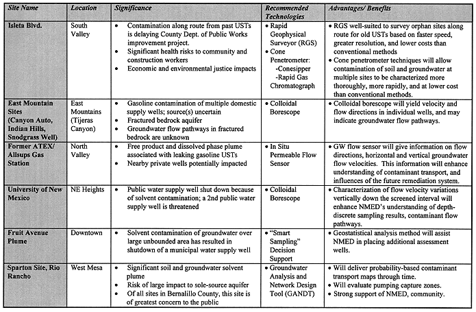
The Rapid Geophysical Surveyor (RGS) was developed at Idaho National Engineering Laboratory, Idaho Falls, ID, and is licensed by Sage Earth Science, Idaho Falls, ID. The RGS uses magnetic sensors to detect buried ferrous objects, including underground storage tanks. The RGS is mounted on a rolling wheel with an optical encoder, and collects magnetic field data every six inches as it is pushed by the operator. Data are downloaded into a portable computer at the site, and a map illustrating anomalies in the magnetic field is generated. The RGS uses similar sensing technology to conventional magnetic geophysical survey tools, but its data logging capabilities allow it to collect far more data. For example, at 0.5 meter profile spacing, the RGS collects more than 50,000 data points per acre, whereas a conventional magnetometer survey using a typical 2-meter grid would collect 1,000 data points per acre. As a result, the RGS has significantly better resolution, allowing smaller objects to be detected, and greater certainty in interpreting survey results. The cost per data point is dramatically reduced, with RGS data costing approximately $0.005 per point, in comparison with conventional survey costs of $2.50 per point4.
The RGS was used to survey 18 sites along Isleta Boulevard which are suspected of having abandoned underground storage tanks which were never removed, and may have leaked petroleum products into the soil and groundwater. The RGS results suggest USTs are still present beneath eleven of the sites5. Bernalillo County Division of Public Works and the Bernalillo County Environmental Health Department will remove tanks at these sites in February and March, 1998.
TABLE I. Summary of Selected Sites and Technologies
Smart SamplingTM, developed at SNL, Albuquerque, NM, is a "decision support" system of geostatistical analysis that can be performed on personal computers. The system helps environmental managers and regulators to evaluate where additional samples should be taken at contaminated sites, and to analyze the extent of remediation based on risks inherent because of the lack of subsurface information. Smart SamplingTM allows decision makers to evaluate costs of sampling and remediation variations, so that public and regulatory objectives may be satisfied at significant cost savings. For example, Smart SamplingTM was utilized at the DOE Mound Facility in Miamisburg, Ohio, to assist in the cleanup of a mile-long section of plutonium-contaminated soil along a canal. This application of Smart SamplingTM saved costs in excess of $1,000,0006.
The TDI Project utilized Smart SamplingTM techniques to recommend beneficial locations for additional monitoring wells at the Fruit Avenue Plume, a large and undelineated body of solvent-contaminated groundwater beneath downtown Albuquerque7. The TDI analysis was performed by GRAM, Inc., of Albuquerque, NM, under the auspices of SNL.
The In Situ Permeable Flow Sensor was developed at SNL, Albuquerque, NM, and licensed to HydroTechnics, Inc., also in Albuquerque. This sensor evaluates ground water flow direction and velocity in three dimensions. The device consists of a cylindrical heater 30 inches long by 2 inches in diameter with an array of 30 temperature sensors on its surface. The sensor is buried in direct contact with the saturated formation. Electrical power is then applied, resulting in temperature increases in the surrounding soil and groundwater from 20 to 30 degrees Celsius. Groundwater flowing past the probe results in relatively cool temperatures on the upstream side of the device and relatively warm temperatures on the downstream side. Data collected from the 30 temperature sensors are analyzed using proprietary software. The sensor is capable of accurately measuring Darcy velocities in the range of 0.01 to 1 ft/day (3x10⁻⁶ to 3x10⁻⁴ cm/sec), with resolution to 0.001 ft/day (3x10⁻⁷ cm/sec). Long-term monitoring of the sensor may be used to evaluate seasonal variations or influences of nearby pumping.
The In Situ Permeable Flow Sensor has advantages over conventional methods for evaluating three dimensional flow direction and velocity in that only one boring is needed, as opposed to conventional methods requiring at least three wells to evaluate horizontal flow, and at least two wells screened at different depth intervals to evaluate vertical groundwater flow. Also, conventional methods require costly aquifer testing to measure the hydraulic conductivity of the formation so that the velocity can be calculated, whereas the In Situ Permeable Flow Sensor measures velocity directly. The sensor can relay data remotely via modem, eliminating the need for personnel to visit the site to obtain data8.
The TDI Project installed this sensor at a former UST site on October 16, 1997, and will continuously collect data for six months. The site has an apparent free gasoline product thickness up to 11 inches, and a dissolved-phase contamination plume extending offsite. The total project cost of installing the sensor and continuously monitoring it for six months is approximately $6,000. For comparison, installing five wells at the site, performing an aquifer pump test, and monitoring water levels monthly for six months at this site may cost from $12,000 to $15,000.
GANDT is a decision support software package for personal computers that can be used to analyze contaminant transport both through soil and groundwater. GANDT was developed at SNL, Albuquerque, NM, and licensed to DecisionFX, Bosque Farms, NM. The software combines statistical methods and physical principles of water and contaminant transport, allowing uncertainty in subsurface conditions to be quantified. The GANDT code is among the most comprehensive flow and transport simulators available, allowing users the ability to: 1) perform scoping calculations with analytical models for rapid proof-of-concept simulations; 2) perform probabilistic Monte Carlo analyses to quantify uncertainties; 3) evaluate the effects of spacial variability with geostatistics; 4) condition simulation results based on observed water quality data (essentially a built-in calibration procedure); and 5) display real-time results of simulations, including spatial depictions of plumes and plots showing the probability of exceeding specific concentration thresholds)9.
GANDT may be used to evaluate uncertainty in the nature and extent of contamination; to analyze the likelihood of success of various cleanup options; and to define the numbers of wells and locations necessary to characterize a plume of contaminated groundwater. GANDT allows evaluation of critical decision issues facing industries and regulators, resulting in significant cost and time savings. For example, cost/benefit analyses performed for UMTRA sites utilizing GANDT indicated potential savings in excess of $30,000,000. In another GANDT application, SNL convinced the New Mexico Environment Department that additional groundwater monitoring wells at the Chemical Waste Landfill were unnecessary, resulting in a cost savings of $750,00010.
The TDI Project is utilizing this software to model contaminant transport and evaluate cleanup alternatives for the Sparton Site in Rio Rancho. Sparton is associated with a solvent-contaminated groundwater plume approximately 1/2-mile wide and one mile long. Modeling efforts by DecisionFX began in late November, 1997, and will be completed in mid-February, 1998.
The Colloidal Borescope was developed at Oak Ridge National Laboratories, Grand Junction, CO. This instrument consists of a system of lenses and two miniature videocameras that can be lowered into wells as small as 2 inches in diameter. The upper videocamera views a compass for orientation, and the lower videocamera tracks microscopic particles called colloids that move along with the groundwater. Analysis of the videotapes allows the horizontal ground water flow direction and velocity to be directly measured. The instrument is lowered through the entire vertical extent of the well screen, giving hydrogeologists a direct measurement of which soil or rock units may be the primary pathways for contaminants moving with the groundwater. The colloidal borescope has advantages over conventional methods for evaluating horizontal flow direction in that only one well is needed, as opposed to conventional methods requiring at least three wells to evaluate horizontal flow. Also, conventional methods require costly aquifer pumping tests to obtain data necessary to calculate ground water velocities11, 12.
The TDI Project will utilize the colloidal borescope in wells in Tijeras Canyon affected by leaking gasoline underground storage tanks, and in a water supply well at the University of New Mexico which has been shut down due to solvent contamination. Field work will be performed in February, 1998.
Cone Penetrometer Subsurface Characterization Tools
Cone penetrometers are large truck-mounted hydraulic presses that push rods into the ground. Depths as great as 300 feet have been reached. The tip of the cone penetrometer is equipped with sensors that allow lithologic variations to be evaluated in great detail. Unlike conventional drilling techniques, no contaminated cuttings are produced, resulting in greater safety for workers and nearby public, and eliminating the costs of storage and disposal of contaminated soil cuttings13.
The TDI Project will deploy two DOE-developed technologies using the cone penetrometer: the ConesipperTM, and the Rapid Gas Chromatograph. These technologies were developed at the DOE Savannah River Site, Aiken, South Carolina, and DOE Morgantown, West Virginia. The Conesipper is a system of miniature pumps within the cone penetrometer tip capable of collecting soil gas or ground water samples14. These samples are then drawn directly into the Rapid Gas Chromatograph (RGC), which can give concentrations of gasoline compounds within as few as 10 seconds15, 16. Conventional gas chromatographs require a minimum of 30 minutes. The combination of the lithologic sensors, the Consipper, and the RGC will allow hydrogeologists to evaluate subsurface lithology and contaminant concentrations far more quickly, safely, and at significantly lower costs than conventional drilling and sample collection techniques. The TDI Project plans to deploy these technologies at sites along Isleta Boulevard after underground storage tanks discovered using the Rapid Geophysical Surveyor are removed. The TDI Project will also utilize these technologies to investigate a landfill which is a suspected source of perchloroethylene (PCE) contamination in groundwater.
In situ thermal enhanced vapor extraction applies standard alternating electric current (AC) and/or radiofrequencies (RF) to subsurface soils contaminated with organic compounds, allowing the soil to be heated to temperatures up to 240 degrees celsius. At such high temperatures, organic compounds will vaporize virtually completely, allowing the contaminants to be drawn out of the soil by applying vacuum to wells installed into the contaminated soil zone. The vapors are then treated by aboveground systems. This type of TEVES configuration was successfully demonstrated at Sandia National Laboratories’ Chemical Waste Landfill, Albuquerque, NM17.
Thermal enhanced vapor extraction allows cleanup times to be significantly shortened relative to conventional vapor extraction (e.g. several months vs. years), and allows contaminants to be reduced to levels far lower than what may be achieved using conventional methods. Thus, the method has significant cost and environmental benefits. For example, a study of total lifecycle project costs indicated that TEVES costs per cubic yard were approximately 25% of the costs for excavation and treatment, and approximately 50% of the costs associated with excavation and disposal at a RCRA facility18.
The TDI Project plans to "scale-down" TEVES for deployment at a UST site in 1998. Potential deployment sites include the orphan sites along Isleta Boulevard that may have tanks according to the Rapid Geophysical Survey Results. Final selection of a suitable site can not be made until tanks are removed, and the DOE cone penetrometer technologies are deployed to characterize the extent of contamination at each leaking tank site.
POTENTIAL TECHNOLOGIES FOR YEARS 2 & 3
Based on the successful development of the site and technology databases during Year 1 of the TDI Project, many highly desirable DOE characterization and remediation technologies have been identified which would be suitable for deployment at Bernalillo County sites which pose the greatest human health risks. Based on BCEHD’s mission to clean up environmental problems, and requests by the public to do more than simply characterize sites, the TDI Project intends to focus on more heavily on remedial technologies than characterization technologies during Year 2. However, specific sites and technologies have not been selected to date. Below is a potential list of technologies that the TDI Project may consider for deployment in Year 2:
Site Types: gasoline UST, solvents, radionuclides
Site Types: gasoline UST, solvents
Site Types: scale down for a typical gasoline UST site; use AC heating only
Site Types: landfill VOC contamination, gasoline UST or solvent sites with contamination under buildings. Perform in conjunction with conventional vapor extraction
Site Types: gasoline UST or solvent sites
Site Types: gasoline UST or solvent sites
Site Types: gasoline UST or solvent sites
Site Type: East Mountain bedrock sites
Site Type: solvent-contaminated soil and/or groundwater
The TDI Project will convey additional information on technologies as they are deployed.
In the first year of the TDI Project, significant progress has been made toward the project mission of making cutting-edge technology and information developed by DOE more available to local governments and enforcement agencies faced with costly environmental cleanups. The Project has accomplished the following goals:
Future activities include deployment of additional DOE technologies at sites in Bernalillo County, and continued conveyance of the processes and lessons learned to states, counties, and cities throughout the United States.
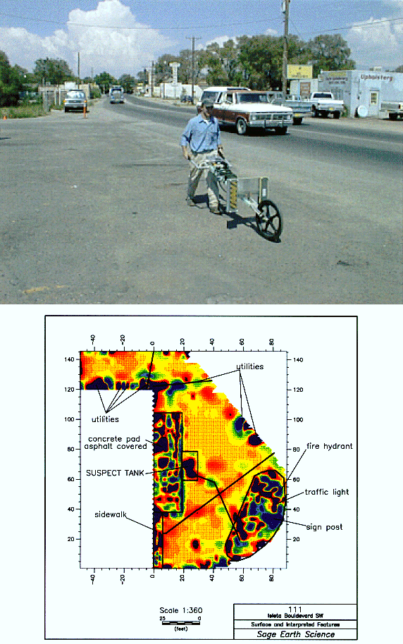
Fig. 1. Rapid Geophysical Surveyor, Example Output.
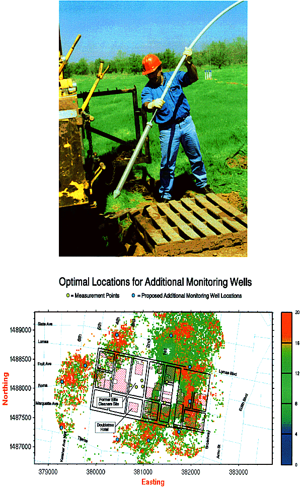
Fig. 2. In Situ Permeable Flow Sensor, Smart Sampling Example Output.
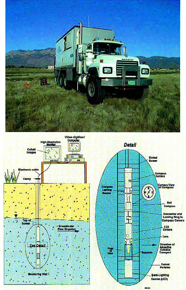
Fig. 3. Cone Penetrometer, Colloidal Borescope.
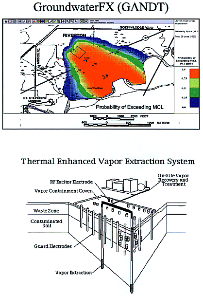
Fig. 4. GroundwaterFX (GANDT), Thermal Enhanced Vapor Extraction System.
1. U.S. Department of Energy, Office of Environmental Management - Technology Development Documents:
2. WILLIAMS, C.V., BURFORD, T.D., ALLEN, C.A. August, 1996. Techhnology Integration Project: Environmental Restoration Technologies Department, Sandia National Laboratories. Sandia Report SAND96-2001, UC-600. Sandia National Laboratories, Albuquerque, NM 97185 and Livermore, CA 94550. US Department of Energy Contract DE-AC04-94AL85000.
3. Global Network of Environmental Technology (GNET) - Internet Website: www.gnet.org
4. SAGE EARTH SCIENCE; brochures and example reports describing the Rapid Geophysical Surveyor (RGS), 1997. Sage Earth, Science, 2300 N. Yellowstone Highway, Suite #206, Idaho Falls, ID, 83401. Contact: Glen Carpenter, 208-522-5049.
5. SAGE EARTH SCIENCE; Letter Report: RGS Surveys, Suspect Tank Sites, Isleta Boulevard, Albuquerque, New Mexico. October 10, 1997.
6 . SANDIA NATIONAL LABORATORIES Project Report, "Demonstration of Smart SamplingTM at the Mound Canal Site". August 25, 1997. Sandia National Laboratories, Albuquerque, NM.
7. ZIMMERMAN, D.A., "Smart Sampling Techniques Applied to a TCE Plume in Downtown Albuquerque, New Mexico", 1997. GRAM, Inc., 8500 Menaul Blvd., NE, Albuquerque, NM 87112, phone 505-299-1282. Paper may be viewed at: http://www.nmia.com/~graminc.
8. HYDROTECHNICS, INC. 1997. The In Situ Permeable Flow Sensor: A Tool for Monitoring 3D Groundwater Flow Velocity. HydroTechnics, Inc., PO Box 92828, Albuquerque, NM 87199. Contact: Sandy Ballard, President, 505-797-2421.
9. METZLER, D., PLIENESS, R., KNOWLTON, R., PETERSON, D., ZHANG, H., AND KNOTT, J., "Implementing the natural flushing strategy: an approach to meeting the EPA ground water standards at select uranium mill tailings sites", Tailings and Mine Waste ‘97
ã 1997 Balkema, Rotterdam. ISBN 90 5410 857 6.10. KNOWLTON, R., "Introducing Groundwater FX", DecisionFX promotional literature, 1997. DecisionFX, 310 Country Lane, Bosque Farms, NM 87068. Phone: 505-869-0057, e-mail: info@decisionfx.com, http://www.decisionfx.com
11. KEARL, P.M., April 1997. Observations of Particle Movement in a Monitoring Well Using the Colloidal Borescope. Journal of Hydrology 0022-1694/97. PII S0022-1694(97)00026-7.
12. KEARL, P.M., KORTE, N.E., STITIES, M., BAKER, J., 1994. Field Comparison of Micropurging vs. Traditional Ground Water Sampling. Ground Water Monitoring and Remediation, Fall 1994 Issue.
13. U.S. Department of Energy, Office of Environmental Management - Technology Development, June 1995. Contaminant Plumes Containment and Remediation Focus Area - Technology Summary. pp. 56-58. DOE/EM-0248.
14. U.S. Department of Energy, Office of Environmental Management - Technology Development, June 1995. Characterization, Monitoring, and Sensor Technology Crosscutting Program - Technology Summary. DOE/EM-0254.
15. BRATTON, W.L., AND FARRINGTON, P.E., "Measuring Fuel Contamination Using Cone Penetration Testing and High Speed Gas Chromatography", Applied Research Associates, Inc., 120-A Waterman Road, South Royalton, Vermont, 05068.
16. ELECTRONIC SENSOR TECHNOLOGY, "Model 4100 Vapor Detector and Analyzer", 1977 promotional literature. Electronic Sensor Technology, 2301 Townsgate Road, Westlake Village, CA 91361. Phone 805-495-9388.
17. PHELAN, J., REAVIS, B., SWANSON, J., CHENG, W., DEV, H., AND ENK, J., "Design, Demonstration and Evaluation of a Thermal Enhanced Vapor Extraction System", August, 1997. Sandia Report SAND97-1251 UC-2010. Sandia National Laboratories, Albuquerque, NM 87185.
18. BREMSER, J., AND BOOTH, S.R., May 1996. Cost Studies of Thermally Enhanced In Situ Soil Remediation Technologies. LANL Environmental Technology Cost-Savings Analysis Project (ETCAP). Los Alamos National Laboratory, Los Alamos, NM, 87545. Report LA-UR-96-1683.