INFILTRATION MEASUREMENTS FROM A WATER BUDGET
AT APACHE LEAP RESEARCH SITE, ARIZONA
E. G. Woodhouse, R. L. Bassett, and W. J. Shuttleworth
University of Arizona
ABSTRACT
The goal of this research was to determine what fraction of precipitation is available for recharge to a perched water zone in fractured, welded tuff at the Apache Leap Research Site (ALRS) near Superior, Arizona. The investigation produced order-of-magnitude estimates of all components of the water budget in a remote, highly heterogeneous terrain in a semi-arid environment. Several challenges were faced in the collection of data for infiltration measurements. First, the measurements were desired from a region of highly varied ground cover, slope, and aspect which is unsuitable for direct, point measurements of infiltration. Second, in order to avoid point measurements, micrometeorological measurements were desired, from a region of limited fetch, high relief, and considerable rock cover. Third, in order to try to directly measure evapotranspiration as part of the water budget, state-of-the art equipment was employed, but the equipment was designed for warmer, humid climates and in accessible locations where it could be monitored frequently, conditions that do not describe the ALRS. Thus, the production of infiltration measurements from this site, while only estimates, provides new data regarding the climatic and hydrologic conditions in such a region. These data can be used in surface or subsurface models as boundary conditions or calibration parameters, to further study the movement of water in fractured rock in semi-arid environments.
The results of the infiltration calculations show that in spite of numerous fractures intersecting the surface, upwards of 90% of the water entering the study area watershed (precipitation) leaves as evapotranspiration, on an annual scale. An additional 6% exits the watershed as runoff, leaving only approximately 4% to infiltrate. This amounts to only about 10 mm/year infiltration, a very small quantity. An average annual infiltration rate of a conservative 5 to 10 mm, over the entire watershed, would equal the estimated volume of the perched aquifer beneath the watershed in 105 to 210 years, assuming 5% matrix porosity plus fracture space. For an effective perched aquifer porosity of 1 %, only 21 to 42 years would be required.
The greatest proportion of infiltration appeared to occur during a 74-day long wet season, when 13% of the precipitation that fell over the period was not accounted for by runoff or evapotranspiration. The increased infiltration during this period may be due to the type of storms that occurred: winter-type, frontal storms which have relatively low spatial variability and low intensity. In contrast, more intense summer monsoon storms are likely to produce large amounts of precipitation, but over such short time periods that much more of the water runs off. These results indicate that in spite of abundant fracture exposed at the surface, the water budget remains fairly typical for a semi-arid region, with evapotranspiration dominating the balance.
INTRODUCTION
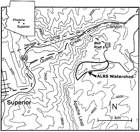
The goal of this research was to determine what fraction of precipitation falling in a watershed is available for recharge to a perched water zone in fractured, welded tuff at the Apache Leap Research Site (ALRS) near Superior, Arizona (Figure 1). The ALRS was chosen as an analog site to Yucca Mountain, the proposed site for a high-level nuclear waste repository. A detailed understanding of the hydrologic regimes present under the geologic, hydrologic, and climatologic settings present at Yucca Mountain is necessary before the site can be determined suitable for a repository. The ALRS has similar climate, geology, and hydrologic conditions to Yucca Mountain, therefore making it a highly suitable natural analog for an independent characterization of the hydrological processes in such a setting. The watershed used in this study covered 51.4 ha.
Fig. 1. Location of the Apache Leap Research Site.
Previous research (Woodhouse, 1997) determined that fractures are the primary pathway by which water reaches the perched zone at the ALRS. If the fractures act as direct pathways, a significant portion of water might be expected to enter the subsurface. However, in arid to semiarid environments, as much as 95% of precipitation has been shown to be lost by evapotranspiration (Harshbarger et al., 1966), suggesting only a small proportion of water infiltrates to the subsurface. Thus, the objective of this research was to determine the significance of fractures to infiltration in the environment of the ALRS.
WATER BUDGET APPROACH TO MEASUREMENT OF INFILTRATION
Infiltration can be measured directly with such instruments as infiltrometers or lysimeters, which are placed directly on the surface and measure the amount of water that passes through the interface to the subsurface over time. These methods generate values for the single point at which the measurement is made; in order to obtain a meaningful estimation of infiltration at ALRS, a seemingly infinite number of such measurements would have to be made to account for all the variations in surface cover, vegetation, fracture density, soil depth, slope and aspect at the site. An alternative to the direct measurement approach is to use the components of the water budget to calculate infiltration. The water budget is determined on a watershed-size scale, which therefore averages conditions over a large area.
In a water budget, precipitation (P) into an watershed is balanced by runoff (R), evapotranspiration (E), and infiltration (I):
|
P = R + E + I |
(1) |
This budget assumes no net groundwater flow into or out of the basin, and no change in surface water storage over time. These assumptions were considered to be valid for the ALRS watershed. Precipitation can be directly measured with recording rain gages, and runoff can be directly measured with recording flumes. Evapotranspiration can measured by both direct and indirect means, so that infiltration is the only unknown in the equation.
Direct Evapotranspiration Measurement with an Energy Balance
Evapotranspiration can be measured directly through the use of an energy budget. In the energy budget, net incoming solar radiation, Rn, is balanced by energy used to heat the air (sensible heat flux, H), energy to heat the soil and rocks (soil heat flux, G), and energy used to evaporate water from the ground and vegetation (latent heat flux, Le). Evaporation from an area over time can be determined by:
|
E = Le / l |
(2) |
where l= latent heat of vaporization.
The latent heat flux can be calculated directly from measurements of a temperature and relative humidity gradient between two elevations, soil temperatures and temperature changes, and net radiation, using the Bowen Ratio Energy Balance (BREB) method. The Bowen ratio (b) is the ratio of the sensible heat flux to the latent heat flux:
|
b = H / Le |
(3) |
It can be calculated by multiplying a constant to the ratio of a temperature gradient to a vapor pressure gradient, where the gradients are the difference between measurements from two elevations:
|
b = c (T2 - T1) / (e2 - e1) |
(4) |
where c is the psychrometric constant, T is temperature (oC), and e is vapor pressure. Subscripts 1 and 2 refer to elevations. The Bowen ratio is related to the latent heat flux by:
|
Le = (Rn - G) / (1 + b) |
(5) |
Net radiation and the soil heat flux can be obtained from field measurements, as can the temperature and vapor pressure gradients. Because the BREB method uses values from meteorological sensors, the fluxes obtained are representative of the conditions upgradient from the recording location, thus they represent an average over an area.
Indirect Measurement of Evapotranspiration Using a Biosphere-Atmosphere Transfer Scheme (BATS) Model
Evapotranspiration values can be modeled using the field-measured parameters of temperature, relative humidity, vapor pressure, total incoming and net radiation, wind speed, and precipitation. The advantage of this approach over direct measurement methods such as the BREB is that the data needed for modeling are collected relatively easily and reliably over long periods of time and from remote locations.
Soil-vegetation-atmosphere transfer schemes (SVATS) are one-dimensional models that have been developed to describe the interactions between the soil, vegetation, and atmosphere. SVATS models are generally used to provide input for larger- scale global change models (GCMs), however, the flux information that they provide can stand alone. One of the more commonly used SVATS is the Biosphere-Atmosphere Transfer Scheme (BATS) model developed by Dickinson et al. (1993), which was used in this investigation.
The BATS model uses the field parameters listed above to calculate a wide variety of fluxes and measurements, including evapotranspiration. In addition to the field data, the model is further keyed to a particular site by soil and vegetation input parameters specific to the site, including soil texture, albedo, initial moisture content, and long-term average temperature; and fractional vegetation cover, and vegetation transpiration and root zone characteristics. Once the data and site parameters are input, the model can be calibrated with additional field-measured data, such as either directly-measured evapotranspiration or runoff data.
DATA COLLECTION
Precipitation measurements were obtained from two recording rain gages placed at ground level, one at a centrally-located micrometeorological station, and one at the top of the watershed. Runoff out of the watershed was recorded by two H-L flumes installed at the watershed drainage outlet. A large flume was used to record discharges greater than 0.01 m3/s, and a small flume downstream of the larger one was used to record discharges up to 0.01 m3/s. The flumes were equipped with pressure transducers sensitive to flows down to 4 L/s. An automatically-recording micrometeorological station was set up in the watershed to collect the parameters needed to calculate evapotranspiration. The area immediately surrounding the station contains both bare rock, sandy soil, and vegetation, so a mixed cover was monitored. .
A Bowen ratio system manufactured by Campbell Scientific, Inc. (CSI) was set up at the micrometeorological station The temperature gradient for the BREB system was measured by thermocouples located at the end of two "arms" that were 4 m apart vertically. The vapor pressure gradient was measured through the difference in relative humidity measured between the two arms. Intake ports on each arm collected air that was ducted alternately to a common dew point sensor which consisted of a chilled mirror hygrometer. Net incoming solar radiation was measured by a net radiometer mounted over an area of mixed ground cover, including bare rock, soil, and vegetation.. Soil heat flux was measured by a combination of two soil heat flux plates and four parallel thermocouples buried beneath the surface. Additional sensors were added onto the station to measure wind direction and wind speed, total incoming solar radiation, and temperature and relative humidity independent of the Bowen ratio system.
RESULTS
Two years of continuous data were collected, from March 1994 to March 1996. The data for the two years are similar; raw data for March 1994 to March 1995 is shown in Figure 2. In general, the data show the yearly trends of higher temperature and radiation fluxes during the summer months, and higher wind speed and humidity in the winter months. The precipitation record for both years showed a pattern of isolated storms, with neither year experiencing the typical distribution of intense, high summer rains and more gentle, longer winter rains, with dry periods in between them. The total rainfall for 1994-1995 was 424.2 mm; for 1995-1996 precipitation was only 321.9 mm, an exceptionally dry period throughout the southwestern U.S.
Single Storm
Measured evapotranspiration data and other water budget parameters were used to determine a potential infiltration volume following a winter frontal-type storm which occurred over a four-day period from January 4 to January 7, 1995. During this period, 16.6 mm precipitation fell over the basin for a total basin rainfall of 8532 m3 , and 7873 m3 of runoff (92% of precipitation) was measured in the flumes. Direct evapotranspiration measurements from the BREB system were not available for this time period (the hydrometer was frozen), however an energy budget constructed during a previous winter frontal storm (for which no runoff data were available), provided an estimate of typical storm period evapotranspiration. An average evapotranspiration rate of 0.115 mm/day was calculated from the BREB data, for a total quantity of evapotranspiration during this time period of just 177 m3. This volume was then divided into a constant rate over the storm period to construct a water budget. The results of the water budget indicate that just 482 m3, or 6% of the precipitation, was available for infiltration. The actual amount of infiltration was probably even less than that, due to further evapotranspiration after the storm. The small fraction of water available for infiltration was not surprising in this situation, as the watershed had received approximately 10 mm rain in the 10-day period preceding this storm, the weather had remained cold and moist during the entire period, the soil and rocks were already saturated, and surface depressions were already full of water.
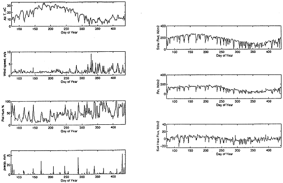
Fig. 2. Weather data from the ALRS for March 1994 to March 1995.
Seasonal Budget
The longest period of frequent rainfall events that occurred during this investigation was from January 1 through March 15, 1995, during which time 147 mm of rain fell. Measured runoff data were available for this period; a depth of 23.7 mm (17% of precipitation) was recorded. BREB evapotranspiration measurements were not available for this period, so the BATS model was used. Measured versus modeled runoff showed a difference of 5%; this difference can be attributed to both mechanical error caused by the flume design, and to assumptions of the BATS model that do not fit the ALRS. Modeled evapotranspiration for the period was 104 mm, or 70% of precipitation. Infiltration calculated according to the measured runoff was 19.8 mm, or 13%. These results suggest that the conditions of winter frontal storms, with relatively low intensities, may enhance infiltration.
Annual Budget
Modeled evapotranspiration was used for calculation of the annual water budgets, as the direct measurements were too discontinuous to be of use. In the first year of modeling, runoff measurements were not available except for during the final three months. The total rainfall in the watershed during this time was 424 mm; the total evapotranspiration predicted by the model was 379 mm, or 89% of precipitation. Runoff during the final three months was 24 mm (5.6%). As several runoff events had been observed, but not recorded, in the watershed earlier in the year, infiltration is estimated to be about 10 mm, or about 2.5% of the annual precipitation. Had no runoff occurred earlier in the year, infiltration could have been at most 21 mm, or 5.4% of the total precipitation. Figure 3 shows the modeled evapotranspiration compared to precipitation for the year: clearly the evapotranspiration rates did not follow a seasonal cycle; rather, peak rates occurred immediately following a precipitation event, and trailed off to nearly zero between events, indicating that evapotranspiration was driven almost entirely by water availability rather than seasonal radiation cycles.
In the second year of modeling, runoff data were collected, but only five measurable runoff-producing events occurred. The BATS model estimated that 95% of the precipitation that fell left the watershed as evapotranspiration. Measured runoff for this period was only 5 mm, or 1.6% of precipitation, leaving just 11 mm, or 3.4% of precipitation, for infiltration. These results seem reasonable, given the overall extreme dryness of the site during this time, and the fact that the two major rainstorms that did occur (in August and February) were short and intense, conditions
which would not favor infiltration. Figure 4 shows a comparison of measured precipitation, and modeled evapotranspiration and runoff for the year. Additional runoff events were predicted by the model, which again could be due to either loss of low flows because of mechanical limitations, or to the differences between the BATS assumptions and the site conditions.
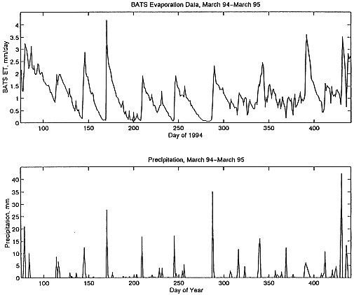
Fig. 3. BATS modeled evapotranspiration compared to ALRS preciptation, March 1994-March 1995.
DISCUSSION
Limitations of the Method
The limitations of the BREB system in the field were considerable. The system did not prove to be a reliable long-term method for collecting direct evapotranspiration measurements in the environment of the ALRS. The two primary reasons so little "good" data were obtained by this method are 1) nonsuitability of the chilled mirror hygrometer for the site conditions, and 2) the remoteness of the site, which limited the frequency of calibration, maintenance, and repair of the system.
The limitations of the BATS model for determining evapotranspiration also are due to some incompatibility with the ALRS site. The BATS model assumes a surface cover of either soil or vegetation (or snow or open water), and makes no provision for a cover of rock, more specifically fractured rock, which makes up the majority of the non-vegetated cover at the ALRS. The BATS model divides up the soil into three layers: a surface zone, a root zone, and a total soil thickness zone. In contrast, the soil cover, where present at ALRS, is very thin, and much of the roots of the vegetation have grown down into the rocks. Thus, while the BATS model is extremely comprehensive and contains rigorously tested physics, its results for the ALRS data can only be taken as estimates, given the discrepancies between model assumptions and site realities.
The precision of the water budget values was further limited by the mechanics of accurately measuring runoff and precipitation. The flume setup was unable to measure flow below a threshold value, and while it was able to record the major storms quite successfully, the quantity of runoff as very low flow that occurred is unknown, and could potentially have been sizeable over the course of a year. Errors in rainfall accuracy were also possible, especially during extremely high-intensity rainfalls, when anomalous spikes appeared in the data record. Frequent significant variation between recording rain gage measurements suggested either considerable spatial variation of rainfall, supported by informal measurements of non-recording rain gages scattered over the watershed, or inaccuracies in the instruments in spite of recalibration efforts. Spatial variation could be great enough at the ALRS that simply averaging the rainfall from two locations was not an appropriate method for determining total rainfall over the watershed.
The extreme variability in surface cover, slope, aspect, and seasonality at the ALRS adds an uncertainty to the measurements in addition to their mechanical limitations. A single micrometeorological station in such a varied watershed can not realistically collect true average values for the region, even though it does represent data from a greater area than just a single point. This consideration is further reason for placing no more than order-of-magnitude weight on the values of the water budget that were calculated.
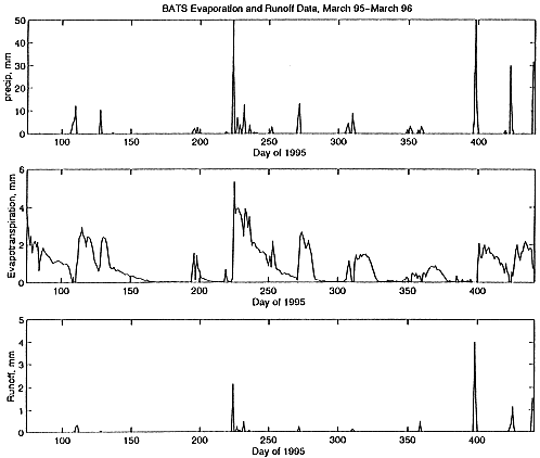
Fig. 4. BATS modeled evapotranspiration and runoff compared to ALRS precipitation, March 1995-March 1996.
Implications from Findings
The annual infiltration quantity that was produced from the water budget was used to estimate the amount of time needed to fill the volume of the perched aquifer, or to completely replace the existing water, beneath the watershed. An average infiltration rate of 5 to 10 mm was used, to account for some low runoff volumes that may not have been recorded. The aquifer thickness was assumed to be 21 m beneath the area of the watershed, based the thickness measured in a borehole in the watershed. The effective porosity of the aquifer, representing matrix porosity and fracture spaces, was then estimated to calculate aquifer volume. For an effective porosity of 5%, 105 to 210 years of average annual infiltration would be required to fill the aquifer volume. If the effective porosity was 1%, only 21 to 42 years of infiltration would be needed. While the effective porosity of the perched aquifer could only be estimated based on existing data, these calculations provide an estimate of the time frames involved in filling the perched aquifer under the current climatic conditions.
Evapotranspiration appears to be the significant source of water loss from the ALRS, and would be expected to dominate at Yucca Mountain as well, given its similar climatic characteristics. The results of the water budget calculations suggest that not a significant amount of precipitation enters the subsurface over the long term under the present climatic regime, but more infiltration occurs during prolonged wet periods of storms with relatively low rainfall intensity. A major implication from this observation is that if climatic conditions should change, bringing an increase in frequency and duration of frontal storms, a greater amount of infiltration could occur.
An additional implication from this investigation that direct measurement of evapotranspiration in a highly heterogeneous natural setting can realistically produce only approximate values, with considerable error likely. Attempts to obtain direct measurements of evapotranspiration using similar methods at Yucca Mountain are likely to produce a similar quality of data. While these methods have produced useful estimates of infiltration values, more precise measurements may be required for proper evaluation of Yucca Mountain for a repository. The use of alternative methods may be warranted for such measurements, perhaps involving expansion of the more traditional point measurement methods to larger regions.
CONCLUSIONS
The results of this investigation have shown that, on an annual basis, only a small percentage of the precipitation entering the watershed is available for infiltration, and that the presence of fractures does not significantly increase the amount of water that reaches the subsurface. Evapotranspiration removes on the order of 90% of the water that enters the watershed; runoff and infiltration together account for only about 10%. In the year for which continuous runoff data were available, runoff was 1.6% of the total budget. The results also showed that more infiltration (13%) occurred during a 74-day period of frontal-type storms, which are typically widespread and less intense than monsoon storms, which force rapid runoff to occur. This result suggests that under different climatic conditions, in which frontal storms are more common, a greater amount of precipitation could reach the subsurface. An average annual infiltration rate of 5 to 10 mm would result in a time of 105-210 years necessary for the perched aquifer to be filled, based on a 5% effective porosity of the aquifer; if effective porosity is only 1%, the aquifer could be filled in 21-42 years.
The process of conducting this investigation revealed several challenges associated with the long-term collection of field data in a natural, remote setting. The heterogeneous terrain made collection of representative data difficult. Mechanical problems invalidated most of the BREB data, and caused periodic loss of data from some other instruments. Use of a BATS model entailed certain assumptions which were not necessarily valid for the ALRS. In spite of these obstacles, estimates of infiltration values were possible, and the data set that has been assimilated is of value for comparison to methods of data collection and analysis in other locations, and for use in water transport models.
REFERENCES