PRELIMINARY DEVELOPMENT OF A COMPREHENSIVE
CALIBRATED SUBSURFACE PATHWAY SIMULATOR
FOR THE SUBSURFACE DISPOSAL AREA
AT THE IDAHO NATIONAL ENGINEERING
AND ENVIRONMENTAL LABORATORY
Swen Magnuson, Jeff Sondrup, and Bruce Becker
Lockheed Martin Idaho Technologies Company
Idaho National Engineering and Environmental Laboratory
ABSTRACT
The first detailed comprehensive simulation study to evaluate fate and transport of low-level, mixed, and transuranic wastes buried in the Subsurface Disposal Area (SDA) at the Idaho National Engineering and Environmental Laboratory (INEEL) has recently been conducted. The study took advantage of pertinent information relating to describing aqueous- and vapor-phase movement of contaminants in the primarily fractured basalt subsurface. The study included spatially and temporally variable infiltration, barometric pressure changes, positive down-hole air pressure during well drilling, vapor-vacuum extraction, and regional hydraulic gradients. Use of the TETRAD simulation code allowed all the pertinent information to be included into a single comprehensive model of the SDA subsurface. An overview of the model implementation and comparisons of calibrated model results to the observed vadose zone water distribution, volatile organic vapor concentrations, and aqueous concentrations of volatile organics and nitrate are presented. Additionally, comparisons between simulated and observed concentrations for other contaminants which were not used for model calibration are made.
As part of this modeling exercise, inadequacies in the available data relating to characterization of non-sorbing aqueous-phase transport have been identified. Even with the identified data inadequacies, the comparisons between simulated and observed contaminants along with the calibration results give confidence that the model is a conservative representation of flow and transport in the subsurface at the SDA. The results from this modeling study are being used to guide additional data collection activities at the SDA for purposes of increasing confidence in the appropriateness of model predictions.
*This work was funded by the U.S. Department of Energy under DOE Idaho Operations Office Contract DE-AC07-94ID13223.
INTRODUCTION AND BACKGROUND
The SDA is part of the Radioactive Waste Management Complex located in the southwest portion of the INEEL. Low-level, mixed, and transuranic radioactive wastes were buried in shallow pits and trenches in the SDA from 1952 until 1970. Since 1970, transuranic waste has been stored in above-grade facilities. Mixed-waste disposal ceased in 1982. Currently, low-level waste is still being disposed in a portion of the SDA. The SDA overlies a thick stratigraphic sequence composed primarily of fractured basalts that are occasionally interrupted by sedimentary interbeds that were deposited during extended periods of volcanic quiescence. The basalt flows are named alphabetically corresponding to the stratigraphic sequence with the youngest flow being called "A". The interbeds are named based on the basalt flows that overlie and underlie them. The three primary sedimentary interbeds beneath the SDA are called the A-B, B-C, and C-D interbeds and occur at depths of approximately 10, 30, and 70 m below land surface. Both the upper surface and thickness of the interbeds vary spatially. In the SDA vicinity, the A-B interbed thickness ranges from 0 to 3.4 m and, where it is present, averages 1.6 m. The B-C interbed thickness ranges from 0 to 12 m and averages 3.4 m. The C-D interbed thickness ranges from 0 to 10.7 m and averages 4.4 m. There are deeper interbeds beneath the SDA but the limited wellbore information indicates they are much less continuous. The Snake River Plain Aquifer (SRPA) underlies the SDA beginning at a depth of approximately 175 m below land surface.
The primary purpose of the SDA simulation study was to perform fate and transport calculations to support an Interim Risk Assessment (IRA) being conducted for the Waste Area Group (WAG) 7 Operable Unit (OU) 7-13/14 comprehensive remedial investigation/feasibility study (RI/FS). The overall approach was to develop a simulation model representative of flow and transport in the subsurface. Representativeness was obtained and demonstrated by calibrating model results to observed water and contaminant data and is a substantial improvement over earlier simulation studies. A secondary purpose of the SDA simulation study was to be able to use the model to evaluate possible remediation strategies and their effects on flow and transport in the OU 7-13/14 feasibility study.
CONCEPTUAL MODEL
The conceptual model used for the flow simulation consisted of spatially variable and time-dependent infiltration at the surface of the SDA. Infiltrating water moved downward under the influence of gravity and capillarity. Downward movement occurred within both the fractured basalt flows and sedimentary interbeds that compose the vadose zone beneath the SDA. The sedimentary interbeds had both variable thickness and variable elevations to the overlying and underlying basalt flow contacts. Perched or near-perched water conditions occurred in association with the sedimentary interbeds when adequate water was either supplied from above or through horizontal movement within the vadose zone. Water movement within the fractured basalts was considered to be controlled primarily by the fracture network. Water that infiltrated at the surface eventually reached the SRPA. Horizontal movement of water within the SRPA caused the water that originally infiltrated at the SDA surface to move laterally within the aquifer.
The transport conceptual model assumed contaminant movement is controlled primarily by advection and dispersion. Because the flow conceptual model consisted of water movement primarily within the higher permeability fractures and rubble zones in the basalt portions of the subsurface, sorption of contaminants onto surfaces within the basalt matrix was considered not to occur. Rather, sorption occurred onto fine-grained sediments or chemical and weather alteration products coating the surfaces of the fractures through which water and contaminants moved. Sorption onto these fracture coatings was estimated based on assumed effective fracture geometries. Including sorption in this manner implied that the basalt matrix did not effect dissolved-phase transport. This is consistent with the simulation results (Magnuson 1995) from the Large Scale Aquifer Pumping and Infiltration Test conducted near the SDA (Wood and Norrell, 1996). Updated estimates of the sediment sorption properties for each contaminant were used. Diffusion of contaminants within the aqueous phase in the fracture system was considered. Diffusion of aqueous phase contaminants into the basalt matrix was neglected. As appropriate, radioactive decay and ingrowth also were included.
The transport conceptual model was further expanded to account for contaminants such as volatile organic compounds (VOCs) that migrate in both the dissolved and vapor phase. This expanded model used the dissolved phase transport conceptual model and further included vapor phase advection, dispersion, and diffusion in a dual porosity system. Partitioning of the VOCs between the aqueous and vapor phases was included. Tortuosity of the porous media was used to modify the mobility of the volatile contaminants in the vapor phase. Influences from barometric pressure fluctuations, air injection from drilling of ~40 wells by air-rotary methods, past vapor extraction events, and buoyancy effects also were included. Release of VOCs to the atmosphere was by both advection and diffusion in the vapor phase. The source term release conceptual model, development and implementation for this SDA simulation study is presented in a separate companion paper.
SIMULATION CODE
The TETRAD code (Vinsome and Shook 1993) was chosen to simulate flow and transport. TETRAD has complete multi-phase, multi-component simulation capabilities. Movement of any number of components within aqueous, gaseous, and oleic phases were considered in the SDA simulation study. TETRAD uses a block-centered finite-difference approach and has capabilities for local grid refinement, which were used extensively. The TETRAD simulator also includes dual porosity simulation capabilities. This feature was used to address gaseous-phase movement in both the fracture and matrix portions of the fractured basalts comprising the majority of the subsurface beneath the SDA.
FLOW MODEL
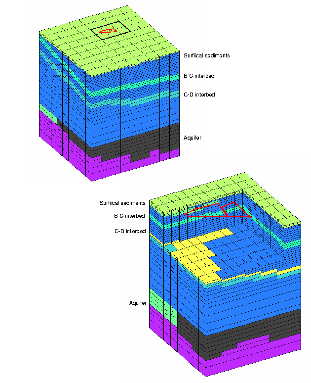
Stratigraphic information on ~90 wells in the SDA vicinity from a United States Geological Survey database were used to assign lithologic properties to the three-dimensional simulation domain. A base grid encompassing the region from north of the SDA to the southern INEEL boundary was defined. Three levels of grid refinement were used in the vicinity of the SDA to provide increased numerical resolution. This refinement was done both vertically and horizontally. Kriging using detrended lithologic data was used to define the depths of the surficial sediments, and the upper surfaces and thickness of the three primary interbeds in the SDA subsurface: the A-B, B-C, and C-D interbeds. These interpreted surfaces were then used to define material property boundaries in the discretized model (Figure 1). Where the discretization was not fine enough to preserve known gaps or "holes" in the interbeds, gaps were manually superimposed onto the kriging results.
Fig. 1. Lithologic assignment in bae and first level of grid refinement with cutaway.
Hydrologic property estimates came from sediment sample analyses (Magnuson and McElroy 1993), basalt matrix characterization (Bishop 1991), and inverse modeling (Magnuson 1995) of the Large Scale Aquifer Pumping and Infiltration Test for the basalt fracture network.
Surface boundary conditions consisted of spatially-varying infiltration. The results of neutron access-tube monitoring at twenty locations inside the SDA was used to develop transient descriptions of infiltration at each monitoring location (Martian, 1995). Three of these locations were selected as representative of low, medium, and high infiltration rates. The time-averaged equivalent infiltration rates were 1, 4, and 24 cm/year for the low, medium, and high regions, respectively. If these three rates are averaged according to their spatial distribution across the SDA, the overall average infiltration rate is 8.5 cm/year.
Three historical flooding events at the SDA (1962, 1969, and 1982) were included in the simulation. Estimates of the volume of additional water that infiltrated were based on work by Vigil (1988). The transient descriptions of infiltration resulted in pulses of water that infiltrated but were damped out with increasing depth as successive interbeds were encountered.
Measured SRPA water levels from 1994 were used to assign prescribed head boundaries on the sides of the saturated portion of the simulation domain. Three permeability regions were assigned to achieve adequate agreement between simulated and measured aquifer water levels.
Calibration objectives in the vadose zone were the spatial occurrence and temporal behavior of perched water that occurs in association with the interbeds. The perched water behavior in the surficial sediments was not used since it was part of the infiltration model calibration. Although the final calibrated results from the flow model were judged to be adequate for simulating fate and transport, the level of discretization in the deeper interbeds was not adequate to allow detailed modeling of perched water behavior.
Primary changes to parameters made as part of the flow calibration were:
Primary observations from the flow modeling were:
DISSOLVED-PHASE TRANSPORT MODEL
Fifty two contaminants were identified for modeling as part of the IRA. From these contaminants, nitrate was selected as the best candidate for calibration of the dissolved-phase transport model. Based on the aquifer monitoring results, there was the possibility of a contribution to nitrate concentrations within the SRPA from the SDA (Figure 2) that could be used for calibration of the dissolved-phase transport model. This determination was complicated by the presence of nitrate in the aquifer from upgradient (relative to flow within the SRPA) sources. An estimate of the SDA local background concentration of 700 m g-N/L was made by Burgess (1996). This local background concentration was assumed to be correct and the portion of the nitrate concentrations above this level were assumed to come from the SDA for purposes of model calibration. This was a conservative assumption since it implies there is already a contribution from the SDA when it cannot be stated unequivocally that there is such a contribution. There is a markedly small number of samples that have been taken from the vadose zone that could be used for transport calibration for any contaminant and especially for nitrate since nitric acid has been added as a preservative for perched water samples.
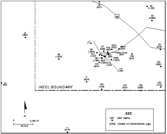
Fig. 2. Distribution of nitrate in groundwater in the southwestern INEEL based on sampling in 1994 and 1995 and simulated (asterisks) and measured (boxes) nitrate aquifer concentrations in one well.
The nitrate release estimated from the source term model was spatially distributed across the SDA (Figure 3). Best-estimates of the nitrate inventory disposed of in the SDA were used for the transport calibration. The calibrated flow model was used and dispersivities were adjusted in the aquifer to improve the agreement between measured and simulated results. Figure 3 also shows a comparison of measured and simulated results for one well as an example.
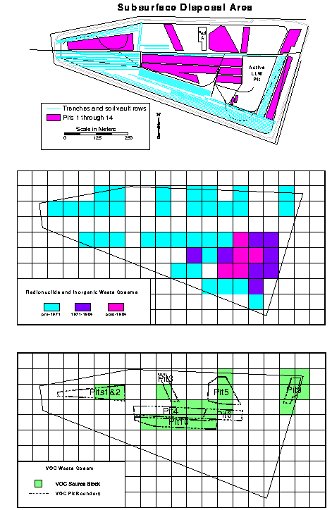
Fig. 3. Subsurface disposal area and assignment of contaminant source releases for simulations.
Primary observations from the dissolved-phase transport modeling were:
COMBINED AQUEOUS- AND GASEOUS-PHASE TRANSPORT MODEL
The calibrated dissolved-phase transport model was further used to calibrate a transport model for VOCs. VOC source locations (Figure 3) were based on historic disposal data, soil gas survey information, and model calibration results. Carbon tetrachloride (CCl4) was chosen to calibrate the VOC transport model because the disposal history was thought to be relatively well known and it is prevalent in the vadose zone and groundwater. Carbon tetrachloride release was governed by the inventory, drum failure rate, and diffusion from a sludge waste form.
The following parameters and conditions were investigated during the CCl4 calibration process: drum failure rate, diffusivity from the sludge, source inventory, source location, vapor phase tortuosities, possible existence of an extensive high permeability layer (rubble zone), basalt matrix porosity, and the amount of air injected during well drilling.
Calibration simulation results were compared to averaged vertical vapor concentration profiles at specific wells, and time histories of vapor concentrations at specific ports, and time histories of groundwater concentrations at specific wells. Figure 4 shows comparisons for two vadose zone vapor monitoring ports and for two aquifer monitoring wells. Comparisons also were made to surface flux and perched water data, but lesser emphasis was given to these comparisons because of the minimal data set.
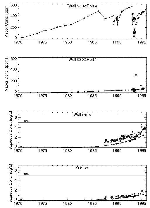
Fig. 4. Simulated (asterisks) and measured (boses) CCl (subscript: 4) vadose zone vapor and aquifer concentrations.
Primary observations from the CCl4 modeling were:
PREDICTIVE MODELING
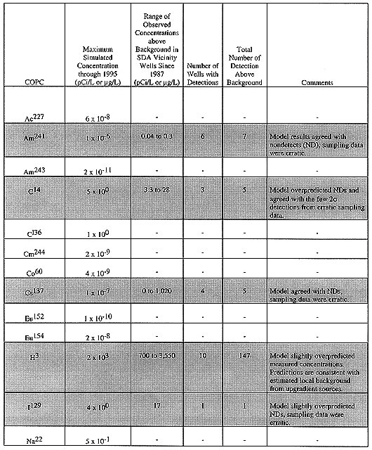
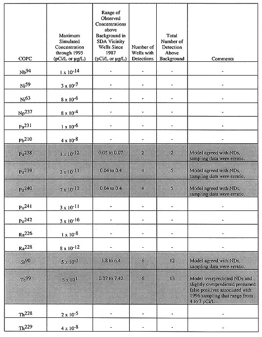
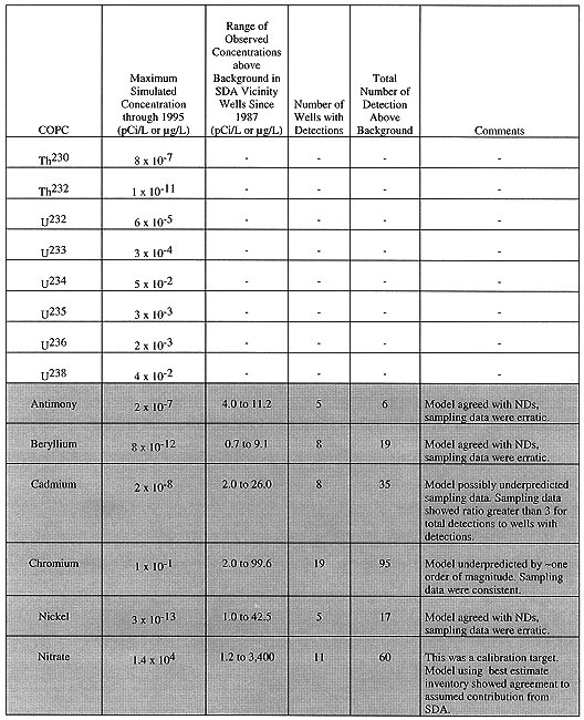
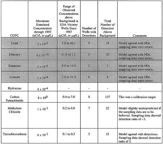
Using the calibrated flow and transport models, 52 contaminants of potential concern (COPC) that remained after a screening process were simulated using upper bound inventory estimates as required by CERCLA. These predicted concentrations were then used in the risk calculations for the IRA. Eight contaminants (carbon tetrachloride, methylene chloride, tetrachloroethene, tritium, chlorine-36, butanone, acetone, and hydrazine) were simulated with the combined aqueous and vapor-phase model. Table I contains comparisons of maximum observed concentrations of each of these contaminants to maximum simulated concentrations anywhere in the model at a depth equivalent to the monitoring locations. It is important to keep in mind when making these comparisons that upper bound inventories were used for the predictive simulations and that the location of maximum concentration in the simulation does not correspond to any of the available aquifer monitoring locations. Contaminants for which any measurements were available are shaded.
Table I. Comparison of Maximum Simulated Aquifer Concentrations through April 1995 to
Measured COPC Aquifer Concentrations Since 1987
SENSITIVITY AND UNCERTAINTY
The sensitivity of contaminants to selected hydrologic and transport parameters was qualitatively determined during the flow and transport calibration process, which resulted in the following observations:
Given the results of the qualitative sensitivity analysis, the largest uncertainties in the predictive simulation results were from uncertainties related to the source term inventory and the description of release mechanisms from buried waste. Uncertainties from the hydraulic and transport parameters used in modeling were smaller than those associated with inventory with the possible exception of some of the partition coefficients that were used.
CONCLUSIONS
This simulation study represents the first attempt to make an all-inclusive effort to simulate contaminant transport of wastes buried in the SDA. Lack of sufficient data from the vadose zone beneath the SDA limit the ability to completely calibrate a transport model. Although there is considerably more aquifer data available, no clear contribution from the SDA can be discerned because of contamination from upgradient facilities.
The process of performing this SDA simulation study has in part been responsible for the initiation of the following additional or continued characterization activities:
Results from these additional activities will be useful in either validating the results of this simulation study or guiding future studies.
REFERENCES