GROUND PENETRATING HOLOGRAPHY TECHNOLOGY
DEMONSTRATION AT THE 618-4 BURIAL GROUND,
300-FF-1 OPERABLE UNIT, HANFORD SITE, WASHINGTON
J. G. April and C. R. Johnson
Bechtel Hanford, Inc.
K. A. Bergstrom and T. H. Mitchell
CH2M Hill Hanford, Inc.
P. R. Gribble and W. M. Lechelt
Pacific Northwest National Laboratory
R.G. McLeod
DOE-RL
ABSTRACT
The U.S. Department of Energy (DOE) Complex supported the Cold War effort through processes that have left sites across the complex that require environmental restoration. One type of site consists of the burial ground. Available data and historical information are available on some of the burial grounds. However, most of the burial grounds in the DOE Complex require further investigation to determine if remediation is required to support planning, remedial design, and health and safety during remedial action.
A new technology has been developed by Pacific Northwest National
Laboratory (PNNL). This technology, non-intrusive penetrating radar holography, has been
applied to various public and military uses. This same approach is being applied to ground
penetrating radar (GPR), which provides two-dimensional images of objects below the ground
surface, with limited enhancement for interpreting what the buried objects are. PNNL has
applied this technology to what is referred to as "ground penetrating holography
(GPH)". Ground penetrating holography applies the same principles as GPR; however,
instead of two-dimensional images, a three-dimensional image is produced using developed
algorithms to enhance standard GPR. This provides real- time images that
can be interpreted by field persons who do not normally work with GPR. This can have
significant advantages for burial grounds and other types of sites.
PNNL and Bechtel Hanford, Inc. have partnered together to demonstrate
this technology at the 618-4 Burial Ground located in the 300-FF-1 Operable Unit at the
Hanford Site, Richland, Washington. The 618-4 Burial Ground is an excellent site to
demonstrate this technology, because of the uncertainty of the burial ground contents and
the knowledge that remedial action will begin four months after the field demonstration
has been completed. The results of this demonstration may provide a non-intrusive
approach that could be applied to the other burial grounds at the Hanford Site.
The purpose of this paper is to present a description and results summary of the GPH demonstration performed at the 618-4 Burial Ground and how this technology could be applied to burial grounds and other sites across the DOE and Federal Complexes. Graphical results will be presented at the Waste Management 98 Conference.
BACKGROUND
Optical holography is a mature technology that is used in many commercial and industrial applications. The holographic processing of radar data is relatively new and was pioneered at PNNL. PNNL has developed holographic radar imaging systems for government and commercial clients for the last ten years. Holography produces radar pictures or images of the buried waste. The three-dimensional images provided location, orientation, depth, and size of the imaged objects.
Under Project RL 342002, active during fiscal year 1995, PNNL was tasked to develop a prototype ultra-wideband radar linear array holographic imaging system operating with a center frequency of 2.5 giga-hertz (GHz). The GPH radar system that was developed produces real-time high-resolution images, but was limited to less than 1 m operational depth under actual buried waste soil conditions. As a result of this limitation, PNNL proposed the development of a low frequency electromagnetic array (LEMA) system that could penetrate to depths of 5 to 10 m (in dry sand).
In fiscal year 1997, PNNL was funded under Project RL37SS41 to develop a single-channel LEMA system and demonstrate its capabilities under real conditions at the 618-4 buried waste site, located in the 300-FF-1 Operable Unit of the Hanford Site. This single-channel system would provide "proof of principle" that would eventually lead to a multi-channel system that could provide real-time computer-generated image results.
The 618-4 Burial Ground was used from 1955 through 1961 to dispose of miscellaneous uranium-contaminated waste materials. Sandness (1992) conducted a geophysical investigation in 1992 to characterize the 618-4 Burial Ground. GPR was one of the key tools used for this investigation. The primary objectives of the investigation were as follows:
The results of the geophysical investigation indicated that the burial ground consisted of a single trench, roughly 32-m wide by 160-m long. The waste was covered with 1 to 4-m of sand and gravel. Minimal information was obtained on the actual types of buried waste.
The 618-4 Burial Ground has been scheduled for remediation in the spring of 1998.
TECHNOLOGY DESCRIPTION
The LEMA system developed by PNNL is composed of three subsystems: an antenna unit, a GPR data acquisition unit, and a holographic processing computer.
The antenna unit is composed of two antennas operating in bi-static mode; one operates as a transmitter and the other as a receiver. This configuration provides excellent isolation between antennas, which maximizes the dynamic range, and, hence, the ability to detect buried objects with low radar return signals. During Cold Testing, antenna operating at 100 MHz, 200 MHz, 300 MHz, 400 MHz, 500 MHz, and 1 GHz were evaluated to determine which one provided the best resolution and depth penetration.
Commercially available GPR data acquisition units were used to collect and store the radar data with corresponding position data. Two commercial units were evaluated during the Cold Testing phase of the project. Position encoders were integrated with the GPR units so that precise position coordinates would be stored with the radar data. The position and radar data were stored in a file with an identifying header containing pertinent scan and operating parameters. The scan files were stored on a removable disk for transport to the holographic processing computer. Approximately 2 hours were required to set-up the scan grid and collect the GPR data on a cleared 10- by 10-m site.
The holographic processing computer consisted of a Sun Ultra 23 workstation with Solaris 2.5.13 operating system software and the PNNL-developed advanced holographic imaging software. After the radar and corresponding position data sets were collected at the buried waste site, they were transported to PNNL’s Engineering Development Laboratory where the holographic processing computer was located. The holographic processing computer processed. the radar data into images.
TEST OBJECTIVES
The project objective was to develop, deploy, and demonstrate the LEMA technology for characterization of buried waste at the Hanford Site. This technology was integrated into the Hanford Site remediation plan as direct support to the 300-FF-1 Operable Unit 618-4 buried waste site. The LEMA demonstration consisted of Cold Testing and Hot Testing.
The objective of Cold Testing (no radiological or hazardous constituent contamination present) was to establish the optimal imaging parameters in Hanford soil and evaluate the image quality on known buried objects. The image parameters that were optimized included radar frequency, spatial sampling increment, time window setting, system gain, and radar velocity in soil. Known buried objects that were imaged included flat plates, caisson structures, cross-site transfer line, underground storage tanks, and a burial trench containing 208-L drums.
The objective of the Hot Testing (radiological contamination present) was to image three areas within the 618-4 Burial Ground. These areas were identified using historical GPR survey data (Sandness 1992) that provided data to focus the three-dimensional GPR test to provide the best results.
COLD TESTING AND HOT TESTING DESIGN
Before LEMA was demonstrated on unknown buried waste at the 618-4 test site, it was necessary to establish LEMA performance on known buried objects. PNNL and Environmental Restoration Contractor representatives from CH2M HILL Hanford, Inc. developed a test plan to address this issue. The test plan consisted of Cold Testing (Cold Testing, meaning no radiological or hazardous constituent contamination) at Little Egypt which is located five miles north of Pacific Northwest National Laboratories. The Cold Testing results provided the basis to evaluate the performance of LEMA during the Hot Testing demonstration at the 618-4 Burial Ground.
Six test areas at Little Egypt were selected to perform system and image parameter optimization. Two of the test areas contained operational verification targets, and the remaining four test areas contained simulated buried waste.
The operational verification sites contained flat plates and barrels buried at different depths. The flat plates were used to determine the radar velocity and wavelength in the soil. The propagation velocity of radar in the soil is used in the holographic processing algorithms. The wavelength determines the spatial sampling requirements. The tiered barrels were used to evaluate image quality and resolution of complex shapes.
Four of the Cold Test sites inspected with the LEMA were mock-ups of buried waste containers used at Hanford. These sites were chosen because each provided a different geometric configuration that could be used for identification when evaluating the three-dimensional image. The first site was a solid waste trench with barrels. The second site was a mock-up of the Hanford 200 Chemical Processing Area cross-site transfer line. The third site was a liquid waste caisson structure. The fourth site contained two large underground storage tanks.
The GPR data was collected over a two-dimensional aperture laid out on the surface of each test site. Each GPR data point position in the aperture must be known to generate holographic images of buried objects. At each test site pre-marked reference poles were installed to establish the aperture grid and spatial sampling increment. The aperture size was limited to a 10- by 10-m or smaller area, determined by the size of the object under examination.
With the aperture grid laid out on the surface of the test site, the GPR system was manually scanned in rectilinear pattern and radar data collected and stored. This data was transferred to the Sun computer where it was holographically processed into images of the buried objects.
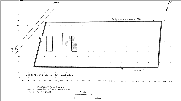
The role of GPR for the Hot Testing at the 618-4 Burial Ground had two purposes. First, GPR played a fundamental role in the selection of the GPH test sites within the 618-4 Burial Ground. Once the test sites were identified, closely spaced GPR profiles were collected at each of the test sites. This data served as the baseline for comparison of the GPR to the GPH data. Figures 1 and 2 presents site map and locations identified for testing, respectively. Figure 3 presents a picture of the single-channel system along with a terrain vehicle that provides transport of the computer supporting the test. Due to the memory requirements of these graphics, they are not included in this paper. However, these results will be presented as part of the presentation at WM 98.
COLD TESTING AND HOT TESTING RESULTS
Hot Test demonstration of the GPH LEMA system was performed at three sites within the 618-4 Burial Ground. PNNL personnel did not have the site qualifications necessary to enter 618-4. CH2M HILL Hanford, Inc. performed the Cold Testing, the GPH data collection, and the baseline GPR surveys.
Baseline GPR data was collected at each of the three-demonstration
test sites. The baseline data was collected using a continuous profiling data collection
technique. This represents a typical final map from a GPR investigation. Features
identified included isolated anomalies, concentration of anomalies, trench boundaries, and
undisturbed areas. The depth of the features is indicated in units of feet and is believed
to be relatively accurate. The exception is linear anomalies that often represent buried
pipelines, cables, or utilities. A tighter survey with higher density sampling would help
to further refine the number and size of the various anomalies, but would not enhance the
identification of the features causing the anomalies.
Most conventional approaches to GPR data interpretation are developed to be fast and cost effective. To meet these requirements, automatic data processing is minimized. However, special care must be taken in the field to collect quality data, thus minimizing the need for processing. The collection of quality data begins with special attention to the data collection parameters. The signal must be properly gained and filtered prior to data collection such that the incoming data can be monitored for data quality. Interpretation of GPR data is a dynamic process that relies heavily on the experience of the interpreter.
LEMA GPH radar data collected at the three sites within the 618-4 Burial Ground were sampled on intervals of 10 cm in discrete point acquisition mode. Discrete point acquisition mode allowed spatial over sampling and stacking (averaging) of many radar signals to optimize image quality.
CONCLUSIONS
GPR is often used to map specific attributes of buried waste sites. The boundaries (e.g., trenches) are often readily identified, and the real extent of the waste (X, Y, and Z) within the trench can be mapped. A limitation of GPR is that it often cannot differentiate between the types of waste/objects that are buried in the burial ground (e.g., barrels, rods, casks). Another limitation is that the interpretation of the data is subjective and relies heavily on the experience of the interpreter. To reduce the subjectivity, the GPR data presentations need to be enhanced so that some physical attributes (e.g., dimensions, orientations) can be clearly identified and key waste features (potential hot spots) can be recognized. The LEMA technology produces holographic images of buried objects, thus making it possible to locate and identify them with greater confidence.
Figure 1. 618-4 Burial Ground Hot Testing Areas.
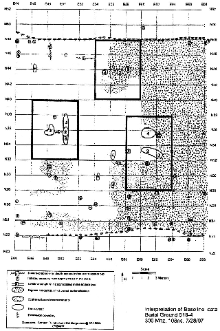
Figure 2. Burial Ground 618-4 GPR Survey Map of Hot Testing Sites.
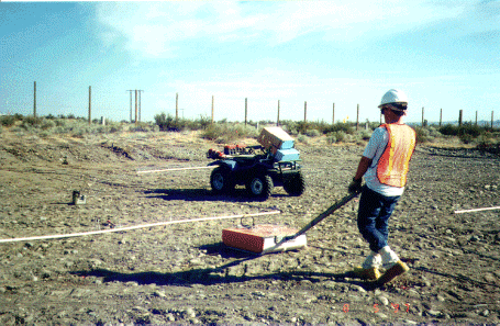
Figure 3. 618-4 Burial Ground GPH Data Collection.
Cold Testing at the Little Egypt site successfully demonstrated the capability of GPH to image buried waste objects in a field scenario. Using a commercial GPR unit operating at 300 MHz, holographic radar images were generated of a cross-site transfer line, burial trench containing drums, caisson site, and underground storage tanks. Equipment and procedures developed during this demonstration are applicable to other burial grounds within the DOE complex.
Hot Testing at the 618-4 Burial Ground successfully demonstrated the applicability of the equipment and procedures developed during Cold Testing to an actual burial ground. The images correlated with the conventional baseline GPR interpretation map. In addition, the images provided clear location, orientation, and depth views of the buried objects.
Once a site has been cleared, it takes approximately 3 hours to collect data with a commercial GPR unit and produce holographic radar images of the buried waste. The development of array technology would provide real-time image capability.
REFERENCES