VARIANTS ON AN AUTOMATED SURFACE GAMMA
RADIATION SURVEYING SYSTEM
C.H. Clement, D. Huffman
Low-Level Radioactive Waste Management Office
Atomic Energy of Canada Limited
1595 Telesat Court, Suite 700
Gloucester, Ontario, CANADA, K1B 5R3
ABSTRACT
Part of the mandate of the Low-Level Radioactive Waste Management Office (LLRWMO) is to resolve historic radioactive waste problems that are the responsibility of the Canadian federal government. To fulfil this mandate, the LLRWMO is routinely required to characterize large areas of land which may have been contaminated by uranium or radium waste. Since 1990, the LLRWMO has been investigating the available alternatives for surface gamma radiation surveys. Several commercial alternatives have been considered, although the most cost effective option to meet all LLRWMO project requirements has been to assemble detection systems in-house using commercially available hardware and custom designed control and analysis software. Several years of prototyping lead to the development of a system consisting of two electronic radiation meters each using a 2x2" NaI scintillation detector. The data from the meters are automatically stored on and analyzed by a portable computer. Many variations based on the initial gamma radiation survey system have been developed in response to the specific requirements of LLRWMO projects. The range of LLRWMO gamma survey requirements has included collecting data at a density of up to four readings per square metre on residential properties to traversing kilometres of densely forested muskeg. For the moderately low activities encountered on LLRWMO projects, sources can be detected to approximately 10 to 20 cm depth. Variations on the general approach to automated data collection have been used widely throughout LLRWMO projects and have been found to be a reliable, reproducible, cost-effective method of conducting gamma radiation surveys.
INTRODUCTION
The Low-Level Radioactive Waste Management Office (LLRWMO) has developed an automated system of data collection, recording and analysis for performing gamma radiation surveys of large areas (several square kilometres or more) in a cost-effective manner. This paper focuses on descriptions of the variations in the data collection system which have been developed in response to specific project requirements, and presents the current status of the system development that was first reported in 19941. Each of these variants is a custom designed adaptation of the basic data collection system first developed by the LLRWMO in 1990. A companion paper2 by the same authors focuses on the general approach of the LLRWMO towards large-area surface gamma radiation surveying, and the results of some of the different types of survey programs. Some analysis techniques applied to the data gathered by the systems described in this paper have been reported previously3.
The LLRWMO is operated by Atomic Energy of Canada Limited (AECL) through a cost recovery agreement with Natural Resources Canada, the federal department that provides the funding and establishes national policy for LLRW management. Part of the mandate of the LLRWMO is to resolve historic radioactive waste problems that are a federal responsibility. Historic wastes are LLRW for which the original owner can no longer be held responsible and which are managed in a manner no longer considered acceptable. If they are wastes for which the federal government accepts responsibility, their management comes within the mandate of the LLRWMO4,5.
In order to fulfil this mandate, the LLRWMO is routinely required to characterize large areas of land which may have been contaminated by uranium or radium waste. These characterizations can serve several purposes including screening level assessments, contamination detection and delineation, cleanup guidance, and verification that criteria have been met following cleanup.
In 1990/91, the LLRWMO began to investigate the available alternatives for surface gamma radiation surveys. With the availability of cost-effective computer technology for field applications, possibilities for overcoming the shortcomings of more traditional gamma radiation surveying methods were beginning to emerge. Several commercial alternatives were considered, although no cost effective options were well suited to the particular requirements of typical LLRWMO projects.
THE DEVELOPMENT OF COMPUTER ASSISTED
SURVEY TECHNOLOGIES
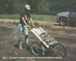
Several years of prototyping lead to the development of a system consisting of two electronic radiation meters each using a 2x2" NaI scintillation detector. This system is shown in use in Figure 1. The meters are controlled by a portable computer, and a 12V battery is used to supply power to the instruments and computer. To provide portability in the field, these components are then mounted on a frame (initially a golf cart, which has lead to the system becoming known as the "cart"). A large part of the success of the system has been the fact that all of the hardware components are commercially available items. This approach has kept development costs relatively low, and means that the repair of an existing system or assembly of a new system is not a major undertaking. However, custom software has been developed for equipment control; data collection, management and analysis; and summary reporting. Commercially available software is generally used for final reporting.
Figure 1. The Basic Gamma Radiation Surveying System Variant
CURRENT DATA COLLECTION SYSTEM VARIANTS
Many variations based on the initial gamma radiation survey system have been developed in response to the specific requirements of LLRWMO projects, although they are now being put to more general use. These variants can generally be classified in terms of three of the basic system components:
Instrumentation
Scintillation detectors are generally used by the system for measurement of gamma radiation. Typically, Eberline SPA-3 2"x2" NaI detectors are paired with Eberline SRM-300 ratemeters and range in number from two to six instruments. Virtually any detector accepted by the SRM-300 can easily be integrated into the survey system. The 2"x2" NaI detectors have been the detectors preferred by the LLRWMO for characterization work due to their sensitivity to gamma radiation emissions at environmental levels. However, the system is readily amenable to surveys requiring the use of energy compensated Geiger detectors for measurement of both beta and gamma radiation or plastic scintillators for more flexible dose rate measurements.
Some experimentation has been conducted using portable gamma spectrometers with sodium iodide detectors. This variation is still under development and so has not yet seen use in LLRWMO projects. Exploranium GR320 and GR256 portable gamma ray spectrometers have been used in this development work.
For road based surveys, gamma radiation measurements are made with a pair of Exploranium 10 litre plastic scintillation detectors connected to GR520 ratemeters.
For all the system variants, measurements are taken automatically, at a fixed rate, and recorded electronically by the controlling computer. All electronic components are used as supplied by the manufacturer, without modification.
Chassis
The method of conveyance is selected for a specific task based on several factors including the size of the area to be covered, data density requirements, and the type of terrain to be traversed. For larger areas, motorized methods, such as automobiles, all-terrain vehicles and tractors are generally preferred. For smaller areas, it is often be more efficient to mount the system on a small, unpowered wheeled frame or even in a backpack. Regardless of the area to be covered, if high data density is required (i.e., greater than one reading per square meter), powered vehicles may travel too quickly and imprecisely and therefore unpowered frames must be used. As well, it may be impossible for a vehicle of any description to travel over certain terrain such as thick forest.
It is not at all unusual for several different survey system data collection variants to be used at a single site with different requirements in terms of data density and terrain over different areas of the site. The data from the different systems can be integrated into a single database for analysis and reporting.
Positioning
The method by which coordinate information is associated with the radiation data varies depending on survey requirements.
In situations where only relative coordinates are required over small areas, dead reckoning can be used. effectively. Dead reckoning requires that the operator enter the current position within the pre-selected (arbitrary) coordinate system, and indicate a direction and speed of travel (generally one meter per second). The system is then moved in the indicated direction at the designated speed. Ropes and other visual indicators laid down before beginning the survey aid the operator in travelling along a straight line at a constant speed. In this way, a survey over a given "block" of the property would be built up with a series of uniformly spaced survey lines generally one-half to one metre apart. Though this is the most labour intensive method of positioning with the automated systems, this method can have sub-meter accuracy under almost any field conditions when carefully executed.
Global Positioning System (GPS) technology has matured over the past few years so that it can be cost-effectively integrated into the survey system to improve location determination. Several levels of position precision requirements have been identified and implemented using different GPS receiver hardware. These range from very large area screening level surveys in which a precision of 100 meters is considered acceptable, to the most precise radiological surveys where there is a need to determine well-defined areas of effect and a precision of one to two meters is required.
For some screening level surveys of very large areas (several square kilometres or more) a precision of approximately 100 m that is associated with standard GPS can be acceptable, although more precise positioning is generally required. This precision may also be acceptable for some road-based surveys. For this level of precision, it has been found that manual correction of location data using noted geographic features identifiable from areal photographs or site drawings is required in almost all cases. This level of precision is very inexpensive and easy to achieve, using any of the widely available, inexpensive hand-held GPS receivers.
For many large-area screening level surveys, a precision of 5-10 m is sufficient. At this precision, manual corrections are generally no longer required, and locations of small to moderately sized radiological anomalies can be determined well enough that they can be reproducibly located on site drawings, areal photographs or in the field. This level of precision can be achieved in real time using inexpensive differential correction methods. Units can be purchased which will receive differential correction signals and transfer them to an inexpensive hand-held GPS receiver.
For more precise radiological surveys, particularly when there is a need to delineate elevated areas for potential future remediation, a location precision of 1-2 m is required. This level of precision can be obtained using more expensive DGPS (differential GPS) equipment, costing roughly $10,000. The primary differences between the inexpensive and the expensive DGPS solutions are the quality of the GPS antenna and receiver, and the more advanced routines used to interpret the signals. The differential information itself is identical.
Ultrasonic positioning has also been investigated for high-precision work where GPS does not function reliably such as near buildings. It has the disadvantages of additional set-up time and does not use a global coordinate system, but it can achieve sub-meter precision without line-of-site to a large portion of the sky or differential corrections as required with GPS.
PROJECT EXPERIENCE
The LLRWMO has been using variants on the automated surface gamma radiation data collection system as an integral part of its survey work for several years. The following case studies provide a good opportunity to describe some of the most widely applicable system variants.
Malvern Remedial Project, Scarborough, Ontario
In 1980, evidence of radioactive contamination was found in a residential area of Scarborough, Ontario, known as Malvern. The material existed as discrete particles, typically less than 5 cm in length, contaminated with Ra-226 with activities generally less than 20 kBq (~0.5 mCi). Redistribution of the soils during construction of the residential development resulted in the discrete particles being spread over approximately 14 hectares of property leaving isolated radioactive artifacts in a large volume of otherwise background soil. Cleanup criteria established for the project were such that where cleanup was undertaken general residual concentrations of 226Ra were not to exceed 0.074 Bq/g (2 pCi/g). As well, all discrete 226Ra contaminated artifacts in the community exceeding 148 kBq (4 mCi) each were to be identified and removed.
In 1994, a survey of the front and rear yards of 450 residential properties was conducted6 using a manually pushed, dead reckoning variant of the survey system, collecting data on each property at a density of approximately four readings per square meter. A small, two-wheeled chassis was developed specifically for this project in order to allow easy access to back yards.
Statistical tools were developed during this program to identify the presence of contamination. Since individual gamma readings were typically within the range of normal background, contamination recognition algorithms relied on the very dense data to identify potentially contaminated areas based on local variability in gamma radiation readings. The 1994 survey program discovered an additional 25 contaminated properties not identified by previous survey programs. Remedial work took place at these properties in 1995.
Former Rayrock Mine Site, Northwest Territories, Canada
The former Rayrock mine site is situated approximately 155 km northwest of Yellowknife, Northwest Territories, Canada. The deposit was mined by Rayrock Mines Ltd. between 1957 and 1959, and then abandoned in operable condition. Uranium ore was milled on site by grinding followed by leaching with sulphuric acid. Tailings were discharged (through a pipeline) into two areas on site.
Decommissioning and rehabilitation of the former Rayrock mine site began in July 1996 by Indian and Northern Affairs Canada. The goal of the remediation program is to inhibit further mobilization of contaminants from the site rather than to remove the contaminants and restore the site to pre-operational conditions. The LLRWMO was retained to determine the surficial radiological status of the former Rayrock mine site at the time when most of the 1996 rehabilitation work had been completed7. The characterization specifically included: the local background, the two tailings piles, the area surrounding the former mill, the waste rock, and a general characterization of the mine site.
Three distinct surveying techniques were employed at the former Rayrock mine site. Each method was chosen to match the terrain to be covered and the level of characterization required. For surveys of the relatively open and accessible tailings piles and dirt roadways, the automated survey system was mounted on an all-terrain vehicle. This allowed for relatively efficient surveys of moderately large areas, although the extremely rough terrain in some areas resulted in a high rate of equipment failure.
Most of the area around the former mine site is muskeg where a second method was more appropriate. The terrain is extremely uneven, and densely forested with small trees. The only possible way to traverse the muskeg was on foot, although navigation was difficult due to the limited visibility within the trees and the going was hard due to the recent rainfall that had made much of the ground very soft. Data were collected using an automated survey system mounted on the back of one operator, while the other operator navigated and recorded location data using a hand-held GPS. East-west lines were walked over most of the site on a one hundred meter spacing.
A third method was used in the muskeg areas where carrying the full backpack system was not feasible, and a lower data density was acceptable. Radiation readings were taken at discrete locations using a digital radiation detection instrument. Location data were collected using a hand-held GPS at each of these locations.
Data from all three data collection methods were integrated following the survey. Although sophisticated automated data analysis methods were not used for this project, the presentation of the integrated data was key in that it allowed useful expert interpretation.
Road Survey of a Small Community
The LLRWMO has developed a van-based system variant which will be used for road surveys. This configuration makes use of GPS technology for positioning and radiation detection is accomplished with either large volume plastic scintillators (for precise measurements) or a series of columnated NaI scintillators (for focused measurements), all carried in a standard mini-van. A linear data density of 0.01 to one readings per meter is used depending on the detectors used and the application requirements. This method of road-based gamma survey is expected to be a useful tool in the identification of contaminated fill materials used in road construction.
The Town of Port Hope, Ontario lies on the north shore of Lake Ontario, approximately 100 km to the east of Toronto. A radium refinery operated in Port Hope from 1933 until the mid 1950s. In 1975, radioactive contamination resulting from practices in the early years of radium and uranium production was discovered in parts of the Town. Over 4000 properties in Port Hope were surveyed and remedial work was carried out on about 400 properties between 1977 and 19818. Due to limited disposal capacities, remedial work concentrated on developed residential and commercial properties. Large volumes of contaminated soil remaining on vacant lands and contaminated sediments in the Port Hope harbour have been left for cleanup at a later date. As well, small quantities of slightly contaminated soils, that is soils with above background radioactivity content but which do not exceed the cleanup criteria, exist along some roads and on some private and public properties.
A van-based survey was conducted over streets in Port Hope in 1997 as a system development exercise. Since the average speed travelled was approximately 30 km/h, the survey was performed during the night in order to avoid potential traffic problems. At this speed, it is possible to cover approximately 200 km of roadway during an eight hour shift. The most appropriate surveying speed will need to be determined on a case-by-case basis depending on the level of precision required. This method of road-based gamma survey will find use by the LLRWMO in future investigative surveys in areas where the LLRWMO has responsibilities. It is expected to be a useful tool in the identification of contaminated fill materials used in road construction.
SUMMARY AND CONCLUSIONS
The many variants of the computer assisted gamma radiation data collection system now play a significant role in the collection of field data on LLRWMO projects. The success of the computer assisted gamma radiation data collection system variants will ensure that they continue to be used in future LLRWMO projects. The development of additional variants is expected to continue as new projects with unique requirements arise.
One of the most important lessons learned during the recent LLRWMO surface gamma radiation survey projects is the value of automated data collection. These surveys can be performed very efficiently when both radiation and location data are collected automatically. It is also important to recognize that GPS technology has matured to the point where useful data can be obtained easily and inexpensively. However, GPS technology is still developing rapidly, with costs continuing to decrease and precision and useability continuing to increase.
REFERENCES