CHARACTERIZATION OF A WINDBLOWN CONTAMINATION
AREA USING A VEHICLE MOUNTED SCINTILLATOR
C. M. Hiaring and F. L Webber
Lockheed Martin Idaho Technologies
Idaho Falls, Idaho, USA
N. E. Josten
GeoSense
Idaho Falls, Idaho, USA
ABSTRACT
This paper presents the results of an in situ radiation survey that was conducted at a Waste Area Group (WAG) 5 site, ARA-23 at the Idaho National Engineering and Environmental Laboratory (INEEL). The survey was conducted as part of a comprehensive Remedial Investigation/ Feasibility Study (RI/FS) to measure and determine the detailed distribution and concentration of Cs-137 in the surface soil.
ARA-23 is a large 240-acre windblown soil contamination area that surrounds both the ARA-I and ARA-II facilities. This contamination is the result of the SL-1 accident and cleanup activities. This study focused on the more contaminated area of approximately 40 acres.
Over 69,000 measurements were collected by the INEEL Environmental Monitoring personnel using a vehicle-mounted scillinator with a Global Positioning Radiometric Scanner system. These data were converted to estimates of in situ Cs-137 concentrations based on methods developed and adapted by INEEL radiation measurements personnel. Converted data were compiled into maps showing the quantitative distribution of Cs-137 across the site.
BACKGROUND
The Stationary-Low Power Reactor No. 1 (SL-1) was a small nuclear power plant designed by Argonne National Laboratory to generate electric power and space heat for the Army at remote Arctic installations. Argonne National Laboratory operated the reactor until February 1959, when Combustion Engineering, Inc. commenced operations. They operated the reactor as a test, demonstration, and training facility for army personnel. By the time the reactor was shut down for the 1960 Christmas holiday, the reactor had expended approximately 40% of its core life.
The reactor was shut down on December 23, 1960 for the Christmas holiday and to perform routine maintenance. On the evening of January 3, 1961, a three-man crew was preparing the SL-1 reactor for startup. The crew was reinstalling the control-rod drive mechanisms, which required lifting the rods a very short distance to make the connection. One of the crew, for unknown reasons, lifted the control rod 20 inches rather than the required 1/4 inch, this caused the reactor to go critical.
A tremendous amount of energy was immediately added to the cooling system of the reactor, which caused uncontrolled boiling of the coolant. This, in turn pushed the column of water above the core and hammered the water into the lid of the pressure vessel head causing the reactor shield plugs to be expelled along with much of the top head shielding. There were three casualties as a result of this explosion and the reactor vessel and building were severely damaged and highly contaminated.
This incident was followed by a massive cleanup operation to dismantle and dispose of the reactor and building. The material from the cleanup operations was sent to the SL-1 burial ground, constructed approximately 1,600-ft northeast of the SL-1 reactor site. During these cleanup activities, surface soils in the area became contaminated with radionuclides, particularly Cs-137. Contamination in the surface soils has been subjected to redistribution by wind over the course of the last three decades. Periodically, particles have been identified on the surface and removed for disposal.
The ARA-23 Windblown Contamination site was identified as a potential hazardous waste release site in 1994 and was included in the Idaho National Engineering and Environmental Laboratory (INEEL) Federal Facility Agreement and Consent Order (FFA/CO) between the Department of Energy - Idaho Operations Office (DOE-ID), Environmental Protection Agency - Region 10 (EPA), and the Idaho Department of Health and Welfare (IDHW).
PROJECT OBJECTIVES
The specific objective of this project was to define the nature and extent of the Cs-137 soil contamination that exceeded 16.7 pCi/g in an approximate 240 acre area. The 16.7 pCi/g definition is based on the residential exposure scenario assumed to begin 100 years in the future after the mandatory institutional control period has expired. The appropriate selection of a Cs-137 distribution model was critical at this site since the stakeholders may require that this site be remediated to the 16.7 pCi/g specific cleanup level.
The ARA-23 site investigation consisted of an in situ gamma radiation survey using a large area plastic scintillation detector and also a ranked-set sampling with laboratory analysis and level A validation. The results of this gamma radiation survey were evaluated in conjunction with the soil sample results. Potential applications of this analysis include defining further characterization activities, defining an interim action or housekeeping activity, providing data for the WAG 5 Baseline Risk Assessment (BRA) and the Feasibility Study (FS) alternative development, substantial reduction in the number of analytical samples required, improved estimates of contaminated material volume, and providing the framework for future remedial actions under the WAG 5 Comprehensive Remedial Action/Remedial Design (RD/RA) phase.
The in situ gamma radiation survey involved measuring gamma radiation from a 1 meter position above the contaminated soil surface. Radionuclides within the soil emit photons. The soil dissipates photon energy through absorption and scattering processes, but some energy escapes the soil zone and radiates outward to interact with the gamma-ray detector. The detector counts these interactions to give a measure of the radioactivity present. The number of gamma rays counted at a given measurement point depends on soil density, gamma-ray energy, detector efficiency and the amount and distribution of the radionuclide in the soil.
The data gathered from the in situ radiation survey will provide information for stakeholders, to define if any further characterization activities will be needed, and to provide improved volume estimates of contaminated soils if a remedial action is required.
FIELD ACTIVITIES
To better meet the objectives at the ARA-23 site, the Cs-137 concentrations from prior surveys and particle picking were kriged into isopleths and the isopleths corresponding to 16 pCi/g or greater were plotted into 25 ft grids. Cs-137 was chosen as the indicator Radionuclide because it is known to be widespread in this area and because it’s 662 keV gamma ray is readily detected by field screening equipment. Sr-90 also occurs widely at this site and is equally important from a risk assessment standpoint. However, as a pure beta emitter, Sr-90 is more difficult to detect using field screening methods. Previous Wag 5 studies show that Cs-137 and Sr-90 are co-located at this site and approximate ratios have been established.
Two types of in situ detectors were used to map the site. First the survey was conducted on the 25-ft profiles with an environmental monitoring Global Positioning Radiometric Scanner (GPRS). The GPRS consists of a large area plastic scintillation detector mounted on the front of a Hummer (commercial version of the military HUMVEE) vehicle equipped with a global positioning system (GPS). The scintillation detector is permanently mounted to maintain a constant detector to ground distance of 1 meter. At this elevation, the scintillation detector has an approximate 25-ft diameter field of view. Scintillator and GPS position data were collected continuously at approximately 2-second intervals during profiling, with the instrument moving at an average speed of 2.5 mph. At this speed the sensor is collecting data approximately every 7 feet. The gamma-ray field intensity from the GPRS is recorded in counts per second (cps).
One of the distinct advantages of in situ measurement relates to the sensor field of view. The field of view may be made quite large through appropriate sensor design, permitting the detector to count photons emitted over an extended area. Thus, even for low radionuclide concentrations, a large number of photon-detector interactions occur and the measurement may be made rapidly.
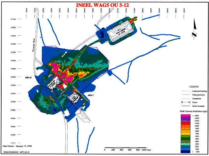
Over 69,000 in situ gamma radiation measurements were collected at ARA-23. The highest cps value recorded at the site was 117,961 cps. The highest areas of gamma radiation readings were in 4 distinct places; a location southwest of the ARA facilities, a location northeast of the facilities, a dirt tract between ARA-II facility and the SL-1 Burial Ground and an area northeast of the SL-1 Burial Ground. Data from the GPRS survey were combined into a database and maps were compiled showing GPS position, data point distribution and bulk gamma radiation (Figure 1).
Figure 1. ARA-23, Bulk Gamma Radiation.
The second type of in situ detector used was the Ge-spectrometer. Eighty-eight Ge-spectrometer measurements were taken at a rocky, debris filled area that was inaccessible to the GPRS and 14 measurements were taken at a selected set of calibration points. The location of this rocky area is just northeast of the ARA-I facility (see figure 1) and extends northwest approximately 200 feet and has a curved appearance. During the measurements the Ge-spectrometer sits on a tripod that maintains a constant detector-to-ground distance of 1 meter. At this elevation, the Ge-spectrometer has approximately the same 25-ft field of view as the GPRS.
DATA COMPILATION
In order to determine the risk to human health and the environment and make risk management decisions for the ARA-23 site, the GPRS count data needed to be converted into Cs-137 concentrations. Several assumptions and approximations went into creating the conversion factor. The background radiation of the area was measured, the response of the plastic scillinator detector was modeled and calibrated, and a linear conversion factor that scales cps to pCi/g was developed. This may be written as C=(cps – bg) * K where
C = Cs-137 concentration
cps = raw data from the GPRS Scintillator
bg = natural background count rate
K = a linear conversion factor
To develop the background (bg), the lowest gamma radiation measurements were recorded at the survey fringes and along several of the radial background profiles. Intermediate values were obtained both southwest and northeast of the reactor facilities all the way to the survey boundary. The background was estimated by examining the cps measurements near the results of soil samples that were below 1 pCi/g. By this method, it appears the background at the ARA-23 site is between 1200 and 1400 cps. This observed variation in background reflects natural variations in soil chemistry, density and vegetation. A value of 1300 was chosen as a best estimate. The calibration of the Ge-spectrometer supported this result.
The development of conversion factor (K) to convert count rates from the GPRS to contamination levels, involved several steps. The initial step was to model the response of the plastic scintillation detector. This modeling was done using the Monte Carlo electron and photon transport code CYLTRAN. The modeling is done for a variety of contamination areas, both in the horizontal direction and depth in the soil and for the soil-detector distance of 1 meter. Conversion factor numbers were developed for 1, 2, 4-inch uniform distribution and 4-inch exponential distribution soil contamination depths. In order to validate the modeled conversion factor numbers, measurements were made with the system on calibrated sources.
The conversion factors developed for converting GPRS count values to Cs-137 concentrations in pCi/g were dependent upon the depth of contamination in the soil. Conversion factors for several different soil depths were developed because the actual depth of contamination in this area was unknown. Prior studies conducted at the INEEL indicated that windblown contamination usually is located in the top 4 inches, but at ARA-23 actual field measurements conducted at the end of the field survey indicated that the contamination is in the top 1.1 inches.
The converted data were combined into the Geologic Information System (GIS) database and maps were compiled showing GPS position, data point distribution and pCi/g concentrations. Maps were generated for a 1-inch, 2-inch, 4-inch and 4-inch exponential soil contamination distribution (Figures 2-4).
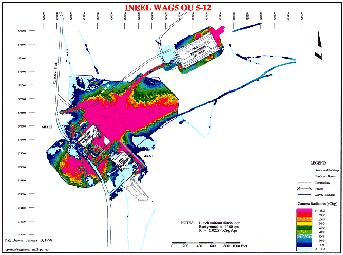
Figure 2. ARA-23, Cs-137 Concentration.
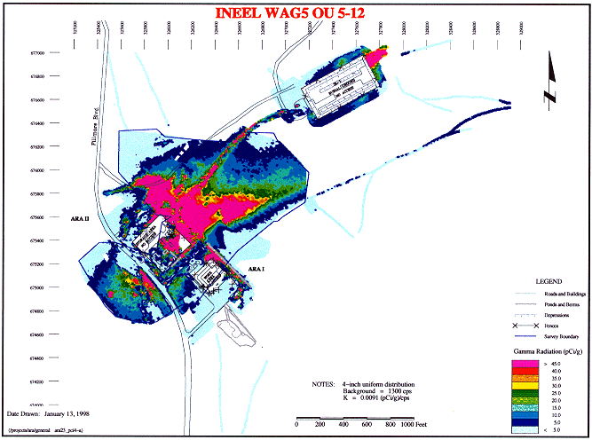
Figure 3. ARA-23, Cs-137 Concentration.
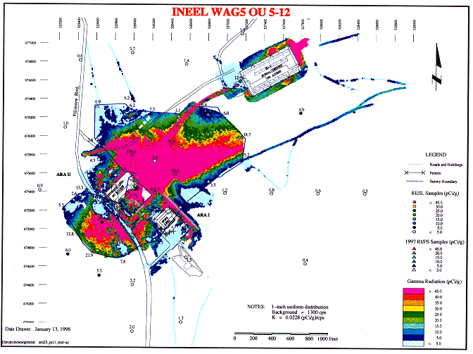
Figure 4. ARA-23, Cs-137 Concentration with RESL and RI/FS Sample Locations.
DATA SUMMARY
Figure 4 shows a summary of Cs-137 concentration data, including the GPRS data converted using the 1-inch uniform distribution model, Ge-spectrometer data for the rock pile area converted to a 1-inch uniform distribution model, and sampling results based on 6-inch cores. Each data set has been plotted using an identical color scheme as shown by the color bar.
The Ge-spectrometer data for the rock pile show a clear continuation of the concentration trend observed for the main Cs-137 plume to the northeast, although a slight discontinuity and trend variation is observed at the northeast boundary between the two data sets. A more pronounced discontinuity occurs at the southwest boundary. Here, the rock pile reveals a broad concentration gradient adjacent to much lower, more uniform concentrations indicated by the GPRS data. The discontinuous boundaries may be due in part to the Ge-spectrometer analysis model which cannot account for the uneven rocky surface in the rock pile and differences in environmental processes and human activities over many years.
Soil sample data corroborate the general trends and concentration estimates determined from the in situ gamma radiation measurements. The soil samples and in situ gamma radiation estimates follow the same general trend up to about 25 pCi/g. Some exceptions occur, primarily in the older soil samples, which tend to report Cs-137 concentrations greater than the more recent sampling activities. This may reflect the averaging that occurs when sample cores extend into relatively clean soils beneath the main layer of contamination and the older samples may have been biased to locations of higher contamination. The two data sets also become erratic when the Cs-137 concentration exceeds 25 pCi/g. One explanation for this is that much of the radioactivity emanates from a small percentage of soil particles and the in situ method averages activity over a 25-ft area and a sample location may coincide with a hot particle.
CONCLUSIONS
The ARA-23 in situ radiation survey was successfully completed by the INEEL Environmental Monitoring GPRS system according to the adopted specifications. Over 69,000 independent measurements were collected at ARA-23. These data were converted to estimates of in situ Cs-137 concentrations based on methods developed or adapted by INEEL radiation measurements personnel. Converted data were compiled into maps showing the quantitative distribution of Cs-137 across this site. The following conclusions are offered:
Cs-137 concentration estimates computed based on scintillation detector data were quantitatively and qualitatively consistent with historical knowledge of the ARA-23 site activities, with independently collected in situ Ge-spectrometer measurements, and with two suites of sample results. Discrepancies between sample results and in situ concentration estimates, which occur primarily in areas of elevated radioactivity, are most likely due to the difference in measurement scale between the two methods.
The precise Cs-137 concentration estimate at any given point was shown to depend on the assumed model for Cs-137 distribution with depth. A set of accessory G-spectrometer measurements focused on the Cs-137 K x-ray and the 662 keV gamma-ray clearly indicate that the Cs-137 contamination is present in the first 1 to 2 inches of soil. This information greatly reduces the uncertainty in concentration estimates, but is strictly applicable only in the vicinity of the accessory measurements.
Cs-137 concentration estimates are subject to additional uncertainty associated with the detector’s unknown low-level discriminator setting. This factor produces a +40% to –20% uncertainty in the Cs-137 concentration estimates, which may be reduced or eliminated by additional laboratory measurements.
Concentration estimates are somewhat sensitive to the choice of a background radiation level. Accessory data were collected to specifically evaluate background radiation levels so that the uncertainty range for background is estimated to be less than + 100 cps. This cps range corresponds to a concentration range less than + 1 – 2 pCi/g.
The final maps depicting Cs-137 concentrations estimates for the ARA-23 site show the distribution and concentration of Cs-137 contamination in great detail. These maps permit unambiguous identification of highly contaminated zones, contaminated roadways, sharp and gradual contamination boundaries; satellite contamination zones and clean areas.
At ARA-23, in situ Cs-137 concentration estimates show the contaminated area exceeding the estimated cleanup level of 16.7 pCi/g to be approximately 30 acres.
A limitation of the in situ GPRS is that only gamma emitters can be measured such as Cs-137. Additional soil sampling would be required at each site to ascertain the relative concentration and distribution of alpha and beta emitters to the Cs-137 and if the gamma emitter is a valid indicator for alpha or beta contamination.
Future use of this technology has the potential to significantly decrease or eliminate the reliance on analytical sampling at sites where gamma emitters can be used as the indicator radionuclide. This method will also improve the survey process during remediation by defining the initial cleanup boundaries followed by another survey of the GPRS to determine if cleanup has been effective.
REFERENCES