| (1) |
LANDFILL COVER PERFORMANCE MONITORING USING
TIME DOMAIN REFLECTOMETRY
Erick R. Neher
Parsons Infrastructure & Technology Group, Inc.
Idaho Falls, Idaho
Debbie McElroy
Lockheed-Martin Idaho Technologies Company
Idaho Falls, Idaho
Gregory B. Cotton
Parsons Infrastructure & Technology Group, Inc.
Idaho Falls, Idaho
ABSTRACT
Time domain reflectometry (TDR) systems were installed to monitor soil moisture in two newly constructed landfill covers at the Idaho National Engineering and Environmental Laboratory. Each TDR system includes four vertical arrays with each array consisting of four TDR probes located at depths of 15, 30, 45, and 60 cm. The deepest probes at 60 cm were installed beneath a compacted soil layer to analyze infiltration through the compacted layer. Based on the TDR data, infiltration through the two covers between March and October, 1997 ranged from less than measurable to 1.5 cm. However, due to a prohibition on penetrating the buried waste and resulting limits on probe placement depths, deeper percolation was not evaluated.
Some of the advantages found in the application of TDR for infiltration monitoring at this site are the relative low cost and rugged nature of the equipment. Also, of particular importance, the ability to collect frequent moisture measurements allows the capture and evaluation of soil moisture changes resulting from episodic precipitation events. Disadvantages include the inability to install the probes into the waste, difficulties in interpretation of infiltration during freeze/thaw periods, and some excessive noise in the data.
INTRODUCTION
This report presents a summary of the application of time domain reflectometry (TDR) for moisture infiltration monitoring at two landfills at the Idaho National Engineering and Environmental Laboratory (INEEL). The intent of the paper is to discuss the practical application of TDR equipment for infiltration monitoring in a soil cover as well as some of the advantages and disadvantages of the technology. These activities are conducted as part of the post Record of Decision (ROD) monitoring for the Central Facilities Area (CFA) Landfills at the INEEL (Department of Energy et al., 1994). The landfill covers and monitoring equipment were installed in the summer and fall of 1996 with final grading and seeding of the cover in the spring of 1997. Infiltration monitoring was initiated in the spring of 1997 following completion of the covers.
SITE BACKGROUND
The CFA Landfills consist of three Comprehensive Environmental Response, Compensation, and Liability Act (CERCLA) landfills with a combined area of approximately 35 acres that are primarily composed of cafeteria, office, and construction waste, and to a lesser extent hazardous waste (waste oil, solvents, and paint). The human health risk posed by the known landfill wastes is considered low, but uncertainties in the characterization prompted the remedial action. The selected remedial alternative for the landfills was construction of native soil covers on each landfill and implementation of institutional controls to minimize infiltration and prevent direct exposure to the buried waste. Long term monitoring of soil moisture infiltration, vadose zone gas, and groundwater was also called for in the ROD.
The soil covers on all three landfills were constructed from the base upwards as follows: (1) a rough grade of variable thickness (approximate 15 cm thickness at TDR system locations) to fill in areas of waste settling and prepare a uniform 0.5 % slope, (2) a compacted layer approximately 30 cm thick with a hydraulic conductivity of approximately 1x10⁻⁶ cm/sec, and (3) a top vegetation layer consisting of 15 cm of loose soil to form a basis for seeding with natural vegetation. All cover layers were constructed of a silty clay (CL-ML) mined locally. Monitoring of moisture infiltration is accomplished through TDR probes installed in the cover to a depth of 60 cm, with neutron probe boreholes for evaluation of deeper percolation. TDR systems were installed on CFA Landfills I and II.
TDR SYSTEM DESIGN
TDR is a proven technique for the measurement of soil moisture content and other soil properties related to the dielectric properties of soil and water (Topp et al. 1980, Ledieu et al. 1986, Heimovaara and Bouten. 1990, Schofield et al. 1994). The TDR method is based upon the principle that when an electromagnetic (EM) pulse travels a finite distance along a wave guide, or probe, the travel time of the pulse, and therefore apparent probe length, is dependent on the bulk dielectric properties of the material surrounding the probe. Because the dielectric constant of water is approximately 20 times that of typical soils, the apparent wave guide length measured through TDR is predominantly affected by the soil moisture content. Additionally, EM waves traveling along the coaxial cable and probes are partially reflected whenever a change in impedance is encountered, such as at the beginning and end of each probe. The measurement of soil moisture content is accomplished through the generation of a high-frequency EM pulse which is applied to the probes buried in the soil cover. The reflected pulse, which contains the apparent probe length, is digitally captured by a datalogger and mathematical algorithms are implemented to convert the signal into a volumetric water content. The volumetric water content, q v, is related empirically to the actual probe length, L, and apparent probe length, La, by the Ledieu equation (Ledieu et al. 1986):
| (1) |
The TDR soil moisture monitoring equipment installed at the CFA landfills was obtained commercially from Campbell Scientific, Inc., of Logan, Utah. The system schematic is shown on Figure 1. The basic components of the system are: (1) the TDR pulse generator/receiver which generates the EM pulse and provides communications interface with the datalogger, (2) a datalogger which stores reflected signals and calculates moisture contents as well as controlling sampling frequency, (3) multiplexers which allow channel switching and sampling of multiple probes, and (4) the buried coaxial cables and probes which transmit and reflect the EM pulse. Three-rod, 30-cm long probes constructed of stainless steel with heavy gauge RG8 coaxial cable were employed for the cable and probes. The system is powered by a deep cell 12 volt marine battery which is charged with a solar panel.
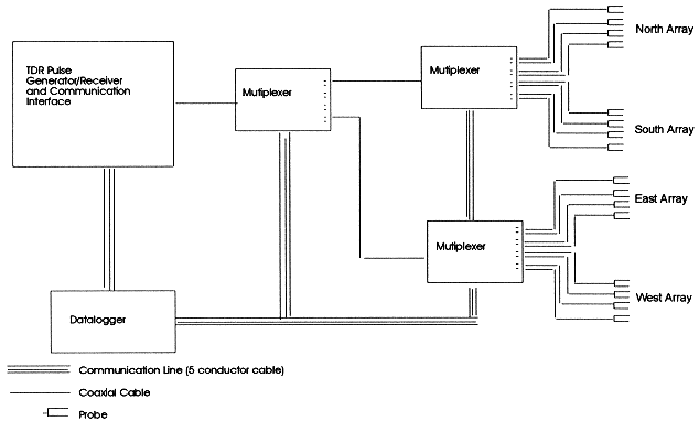
Figure 1 TDR System Components and Schematic Diagram.
INSTALLATION AND OPERATION
The risk to probes and cables from heavy construction machinery prevented installation of the TDR systems concurrent with the cover construction. The probe arrays were installed following cover completion by digging a 1.2 by 1.4 m trench to the base of the cover and installing the probes while backfilling and reconstructing the cover to the designed compaction. In this way, vertical TDR probe arrays were installed into the cover as shown on Figure 2. Soil moisture (vol/vol) is monitored at depths of 15, 30, 45, and 60 cm, corresponding to the base of the vegetation layer, center of the compacted layer, base of the compacted layer, and rough grade. Each TDR system consists of four vertical arrays located radially, north, south, east, and west, approximately 18 m from the central TDR pulse generator and data logging station. (Limitations due to signal degradation require cable lengths of less than 24 m for this equipment.) The stations were located near the base of the slope on each cover in order to be at the location with the highest infiltration potential.
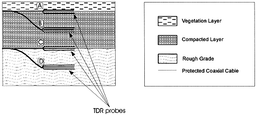
Figure 2 Landfill cover profile and vertical TDR probe placements at A) 15 cm, B) 30 cm, C) 45 cm, and D) 60 cm.
The system operates autonomously based upon programming of the datalogger. Currently, monitoring of each of the probes is performed twice daily, though more or less frequent monitoring is possible. Reflected signals are converted automatically to soil moisture contents and saved as such. Recording only soil moisture data, the systems are capable of operating over 6 months prior to downloading. Downloading of the soil moisture data is accomplished with a laptop computer and communications software. If desired, the system could be modified for data telemetry using radio, cell phone, or satellite transmitters.
SOIL MOISTURE MONITORING DATA AND INTERPRETATION
Soil moisture monitoring data generated by the TDR systems are presented to show some of the capabilities of the system for analyzing performance of the soil covers. Of particular concern for this project is a determination of the volume of water which passes through the compacted layer and enters the base of the cover, or the rough grade. This moisture has the potential for deeper percolation through the landfill waste. Though the probe arrays are not buried deep enough to encompass the maximum evapotranspiration depth of the soil, typically 30 to 150 cm (Martian 1995), they do provide information regarding the dynamics of moisture movement in the cover. Neutron probe monitoring, not discussed in this report, will provide information regarding the potential deeper percolation at this site.
TDR data from the south arrays at Landfills I and II, respectively, are shown in Figures 3 and 4. The plots show the precipitation received and volumetric moisture content for the 15 and 60 cm probes between March and October 1997. The cumulative precipitation over this period was approximately 15 cm. Precipitation data were obtained from the National Oceanographic and Atmospheric Administration weather station located approximately 0.5 km from the landfills. The apparent increase in moisture content during March and early April is the result of thawing of frozen soil. This is most evident in the 15 cm probe data from both arrays where an initial sharp rise in moisture content is observed. The TDR probes cannot accurately monitor soil moisture when the soil is frozen because the dielectric properties of the moisture changes as it freezes (Pepin 1995). As the ice in the soil thaws, the TDR probe records a change in the dielectric properties of the soil resulting in an ‘apparent’ increase in moisture content. For comparison, soil temperature data from the Engineered Barrier Project located approximately 11 km south of CFA at the Radioactive Waste Management Complex, INEEL, show that soil was frozen to at least the 60 cm depth through about March 22, 1997 at which time thawing began. It is assumed that thawing at the Engineered Barrier Project occurred at roughly the same time as at CFA. The timing of the thaw at the Engineered Barrier Project is consistent with the ‘apparent’ rise in moisture content data in the TDR data during late March and early April. Furthermore, there was neither a build up of snow on the ground nor a significant precipitation event to provide a source for infiltration until March 31.
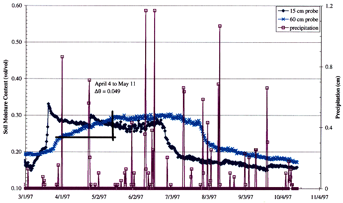
Figure 3 Precipitation and Soil Moisture Data from South TDR Array of CFA Landfill I.
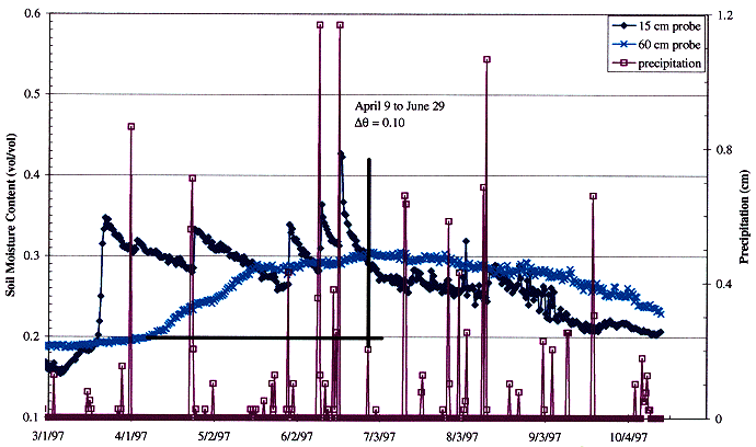
Figure 4 Precipitation and Soil Moisture Data from South TDR Array of CFA Landfill II.
Infiltration through the compacted layer of the cover material did occur at Landfills I and II as evidenced by increased soil moisture content at the 60 cm depth. The largest increase in moisture content occurred in the south arrays at each landfill. The moisture contents at the 60 cm depth in the south array of Landfill I (Figure 3) shows an overall increase from late March to mid-May. While the initial (late March) rise in moisture content at the south array in Landfill I is probably only an ‘apparent’ rise caused by the thawing of frozen ground, the remainder of the rise (mid-April to mid-May) can be attributed to infiltration through the compacted layer. The rise in moisture contents in mid-April occurred well after the thaw. In the south array of Landfill II (Figure 4), the entire rise from mid-April through June is assumed to be due to infiltration, since it occurred after the thaw.
Table I shows infiltration estimates through the low permeability layer at the south arrays of Landfills I and II, based on the increase in moisture content at the 60 cm depths and not including any ‘apparent’ infiltration due to thawing of the soil. Calculations are based upon a soil layer thickness of 15 cm with a 1 cm2 area. The change in moisture content represents the gross change from the initial date to the final date for that increase in moisture content.
Table I. Estimated Infiltration Observed at 60 cm Depth.
ARRAY |
Dates |
Infiltration Over 1 cm2 Unit Area |
South, LF I |
4/4/97 to 5/11/97 |
0.75 cm3/cm2 |
South, LF II |
4/9/97 to 6/29/97 |
1.52 cm3/cm2 |
Infiltration may have occurred in other TDR array locations at both landfills. However, the moisture content increases in all cases, other than those discussed above, were less than 2%, which is within the optimal noise level of the TDR system. Because of the uncertainty of these readings, infiltration amounts were not quantified.
It is also interesting to note the relative response of the 15 cm TDR probes to precipitation events throughout the season at the Landfill I and II locations (Figures 3 and 4). Soil moisture increases at the 15 cm depth following precipitation events are very evident at Landfill II south array throughout the season, while moisture increases at the equivalent depth of the south array at the Landfill I location is not evident following June. This is interpreted to be a result of the relative success of seeding and plant growth on each landfill. A strong growth of native grasses was evident across the entirety of Landfill I beginning in May and lasting throughout the season. However, growth of the native plants near the location of the TDR arrays on Landfill II was inhibited. While infiltration did not proceed beyond the 15 cm depth in Landfill II after June, moisture increases at 15 cm indicate a slower rate of moisture removal through evaporation and transpiration from the cover grasses.
SYSTEM ADVANTAGES AND DISADVANTAGES
The TDR system offers significant advantages for the sensing of soil moisture and monitoring of moisture movement through the landfill covers. The system is fully automated and was relatively inexpensive to purchase and operate. The cables and probes used in the cover are very simple and robust and should provide a long operational life, particularly in the relatively arid location of the INEEL. Calibration of the probes is not necessary in typical, nonsaline, low organic content soils, because the measurement relies predominantly on the difference between the dielectric constant of water versus soil. Because the system is solar powered, it could be remotely located without the need for power lines. The system is easily modified for data telemetry allowing remote operation and downloading of the system. Finally, because the system is effectively operated by the datalogger, unattended sampling at virtually any sampling frequency is allowed. This provides the very important advantage of being able to record moisture content changes resulting from episodic precipitation events, and the data density to evaluate the effects of the those episodic events.
Disadvantages were found through installation and operation of this system. Optimal data generation from the TDR system would have been possible if probes could be placed at depths beyond the maximum evapotranspiration depth typically encountered at the INEEL. However, this would have entailed digging into the buried waste, a prohibited activity. Because of the size and length of the probes, they required hand burial or possibly placement in a larger diameter borehole. Neutron probe tubes, which can be driven directly into the waste without generating any drill cuttings, are not subject to this limitation. Also, evaluation of the early spring data was complicated by the response of the TDR to frozen soils. TDR is not capable of accurately measuring soil moisture when the soil is frozen, resulting in difficulties in determining if soil moisture is actually low or if the soil moisture is simply frozen. Finally, though not apparent in Figures 3 and 4, several of the probes have been found to generate excessively noisy data, with moisture content readings positively biased and varying by as much as 10% to 30% over a 12 hour period. This problem can be mitigated through increased averaging of the data prior to converting to soil moisture values, calculating running median values, and accurately measuring and programming individual cable lengths. It is still evident in the data, however.
CONCLUSIONS
The TDR systems installed at the CFA Landfills provided valuable information regarding the movement of soil moisture through the landfill covers. Analysis of the soil moisture data indicates infiltration ranging from not measurable to approximately 1.5 cm of moisture through the compacted layer in Landfills I and II. It should be noted that at least a portion of this infiltration occurred prior to final grading and establishing native plant growth on the covers. Deeper percolation of this infiltration cannot be determined from the TDR data due to the limitations on placement depths of the probes.
One improvement to the TDR monitoring system which could increase the utility of the data would be the installation of soil temperature probes at equivalent depths of each probe. This would provide information regarding timing of freeze/thaw cycles and improve infiltration estimates during the early spring and late fall periods.
REFERENCES