A SITE FOR HLW STORAGE AND LLW DISPOSAL IN ITALY
Piero Risoluti
ENEA, the Italian National Agency for Energy,
New Technologies and Environment
Roma, Italy
ABSTRACT
Actions are under way in Italy for providing the country with a site for the repository of low active radioactive wastes. Radioactive wastes of any kind have been produced in Italy's nuclear program which began in the early seventies. Four power stations, fuel fabrication plants and fuel cycle pilot plants, including two reprocessing facilities, were in operation in the past years, along with a number of laboratories for basic research.
The total amount of radioactive waste to be disposed occounts for about 180.000 cubic meters, most of them of low radioactivity. HLW wastes will be returned to Italy from the reprocessing in United Kingdom at Sellafield. Spent fuel will also to be disposed after the long term dry storage presently envisaged by ENEL.
At present, two sites (S1 and S2) are under preliminary evaluation for LLW repository. Both sites are also considered for localisation of the centralized facility for vetrified HLW and spent fuel on long term dry storage. A below-grade concrete vault storage design option, which better matchs the ground morphology, is considered in both sites at this stage. Preliminary safety assessment calculations performed showed for the two repository systems good results in terms of regulatory compliance.
INTRODUCTION
Following the referendum held in 1987, a moratorium in the nuclear power plant installation was decided in Italy. Since then, a substantial phase-out of the nuclear activity took place in the country. In the current perspective, there are not realistic plans in to resume positive actions toward a nuclear energy development. A considerable amount of radioactive wastes of low, intermediate, and high level were produced and accumulated in the four power stations of ENEL, as well as in the several fuel cycle laboratories and pilot plants operated by ENEA, the former Commission for Nuclear Energy, now the National Agency for New Technologies, Energy and Environment.
From 1990, all the operational nuclear activities of the country were practically concentrated on the conditioning of the stored wastes. The selection of the conditioning technology was initially carried out, leading to a the following general management scheme :
The need of a site for a LLW repository has been recently stressed by the italian government, which directed ENEA to initiate the action of site investigation and for a preliminary design of the disposal system. ENEA has established a special Task Force for carrying out the actions and preparing the Preliminary Safety Analisys Report. The Task Force began the activity on November 1996.
In order to allow the removing of the spent fuel not reprocessed from the power stations (about 250 tons), a decision has been taken at government level to consider the same site for a centralized facility for long term storage of the spent fuel in suitable dry storage systems. The vitrified canisters expected to be returned in the next years from the reprocessing in UK of the italian spent fuel will also be stored in the same site, which will be an integrated national site for radioactive material storage and disposal .
This paper describes the main features of the two sites presently under evaluation and the repository design options selected.
MATERIAL INVENTORY AND PROJECT TIME SCHEDULE
A total amount of around 180.000 m3 of LLW have to be disposed in the repository. Most of them (around 140.000) will be coming from decommissioning of power plants and reprocessing pilot plants.
230 tons of PWR and BWR spent fuel, remained unreprocessed, will be also stored in the centralized facility. The dry storage systems are presently being selected by ENEL, the national Utility of Italy for electricity production.
About 200 canisters of vitrified HLW, returned from reprocessing in UK, will be stored in a dedicated facility in the site, along with the some 100 canisters of vitrified wastes produced in Italy by solidification of HLW at Eurex reprocessing pilot plant. .
The repository is expected to begin routine operations on 2010 (2007 is the target date for the completion of the construction).
Table I shows the planned actions and the project time schedule for the repository.
Table I. Repository Project Time Schedule
|
PRESENTATION OF THE SAR TO THE LICENSING AUTHORITY : 12/2000; |
|
SITE QUALIFICATION PROCESS AND LICENSING PROCEDURE : 2000-2003; |
|
SITE PREPARATION AND REPOSITORY CONSTRUCTION 2003-2007 |
|
COMMERCIAL OPERATIONS START ON 1/2010. |
Table II shows the loading schedule at the repository. The present amount (1997) of conditioned wastes is around 7000 m3. On 2010, at the start-up of the repository operations, the accumulation of wastes will account for about 14.000 m3.
Table II. Short Lived Waste Production and Loading Schedule
|
YEAR |
VOLUME (m3) |
PACKAGES |
|
1997 |
7.000 |
12.000 standard 400 lt drums |
|
2010 |
14.000 |
20.000 400 lt drums + standard large packages |
|
2040 |
160.000 |
80% large packages standard + 400 lt drums |
SITES UNDER INVESTIGATION
Two sites (S1 and S2) are presently being evaluated in Italy for a surface repository. Other than a possible sites, they represent a test case for performance assessment calculations and scenario identification. Two other sites (S3 and S4) are at the stage of a preliminary evaluation. Six other sites are also being considered. The Sites S1 and S2 are shortly presented below.
S1
The S 1, the northern site, is situated on one of a series of Pleistocene river terraces to the south side of the Po river valley. The Po valley is very wide at this point and the river is some 15 km to the north. The site is on a flat lobate promontory where the terrace is intersected by small rivers and streams flowing north into the Po. The plateau area is between about 300--500 m wide, about 50 m above the stream valley and falls steeply in vegetated slopes into these valleys.
The terrace is composed of at least 70 m (proved in boreholes) of mixed silty and sandy clays with some gravels. The depth of the boreholes varies from 35-80 m. All the boreholes end in a formation defined as a silty sand with inclusions of various lithological natures. Overall, the sediments were preliminary characterised as 'low permeability' in the site evaluation 10 years ago, although they are clearly heterogeneous and can be assumed to comprise complex lenses of fluvial sediments. The water table lies between 10-20 m below the plateau top, rising to 5-7 m in the stream valleys.
The candidate site covers a total area of 141 hectares, of which about 28 ha, being rather flat and lying at the highest elevation, where the water table is relatively deep, seem favourable for the construction of near-surface disposal units.
No part of the entire area falls into the three seismic zones used to classify regions of Italy known to be exposed to seismic risk.
As for the suitability of geological environment as a far-field barrier, clay-rich sediments, such as those occurring at the candidate site, are usually characterized by good retention capacity for both solutes in cationic form and for particulates in water. As for the engineering properties for construction, the nature of the terrace sediments points to ease of excavation.
The site is located in a relatively sparsely populated area. The closest population centers are three small villages that surround the site; two of them are about three kilometers away. The closest large population center is a town which has about 100,000 inhabitants and is about 25 Km away.
The activities in the surrounding area are mainly farming with some residential settlements. The site is a disused governmental area and is currently subject to some institutional control, althoug it is un-manned.
The principal advantageous properties of the site are as follows:
The main disadvantages appear to be:
S 2
The candidate site S 2 is located near the southern edge of the italian southern plateau, at an elevation of about 600 m above mean sea level. The plateau is generally formed by calcareous rocks of Cretaceous age.
The site consists of a storage facility belonging to a governmental institution covering about 140 hectares. The site is located on an outcrop of a typical limestone, which represents the highest member of the calcareous. The limestone is fine grained and light in colour, usually occurring in massive beds. It is reported as having a maximum thickness of around 600 m and is underlain by a further limestone layer of 2,000 metres, and is described as a monotonous sequence of fine grained, detrital beds of whitish limestone with some dolomite. The limestone is characterised by sink holes and fracture systems which are blocked in places both at depth and at the surface by red, clay-rich zones. The water table is one of the deepest in Italy, some 600 m below the plateau.The limestones of the plateau are karstic regionally, and to a limited extent in the area of the candidate site.The limestone is fractured, with 3 to 4 fractures per meter. Many of the fractures, particularly at some depth, are partially filled by red clay, which should reduce their hydraulic conductivity.
The average annual rainfall is quite low. The plateau is practically free of surface water circulation. As for land stability and erosion, in general limestone is a rock The plateau, with the exception of the border areas that may feel the effects of distant earthquakes, is generally considered to be 'aseismic'.
As for probable behaviour and properties as a far-field barrier, fractured limestone cannot be assumed to constitute a hydrogeochemical barrier to radionuclide migration, even if red clay, present in most fractures, is likely to retain some substances transported by percolating water. However, the process is difficult to characterize without detailed hydraulic modelling. This will be a significant aspect to a more detailed performance assessment, should the site be taken in further consideration.
As for human intrusion factor, the site is located in a relatively sparsely populated area near the edge of the plateau. The closest population center is the small town which has about 1,500 inhabitants and is located on the plain about 4 kms south-west of the site. Additional, larger population centers exist in the area but they are significantly farther away. At present, the land at the candidate site and in the surrounding area has a very limited economic interest. The lack of surface water makes farming unattractive.
The principal advantageous properties of the site are as follows:
The main disadvantages appear to be the probable poor retention properties and relatively fast transport through the underlying limestone.
The other sites under investigation S3 and S4 are located in clay formations. They are at the stage of very preliminari characterisation.
REPOSITORY DESIGN OPTIONS
The design objectives for the near-surface waste disposal repository are:
In the current repository design, the three design objectives are met using a combination of six types of engineered features:
Based on the review of current disposal design technology and on the outline geological available information, the preliminary options selected for design basis analyses for the two sites at S1 and S2 are described shortly below. The final choice of design will eventually be made from operational, cost, and detailed site-specific considerations. Analyses of the differences between disposal designs generally suggest that, from a postclosure standpoint, there is little difference between comparably complex designs at the same site, which will clearly leave some flexibility at the subsequent design stages.
S1
The design option for S1 is a concrete vault, which could be either an above-grade or below-grade type. The vaults will be covered with a mutiple layer cover. Either option is likely to provide similar levels of long-term performance. The choice of whether to go for entirely above-grade or entirely or partially below-grade will depend on two key factors:
- detailed site investigation and modelling of the depth variability of the water table in the terrace sediments and the potential for seasonally (or event) perched water tables;
the optimum utilisation of space in the relatively limited area available on the flat top of the terrace; a need for significant surface re-profiling (to maximise suitable areas for vault construction) may adversely affect the hydrology and would be expensive.
The below-grade option tends to minimise land area required owing to the reduced cover area needed; this option is thus favoured at the present stage.
However, some designs of above-grade vault which used a matrix of a small number of large area vaults (several tens of meters wide, as at the Drigg facility in the UK) might be feasible. This design would also reduce area requirements as only a small number of larger covers would be needed. Clearly, in a detailed design optimisation study, there would be the possibility of using a combination of both types of design at the site, to maximise land useage. In the present stage of the project, however, we concentrate on the simple, below-grade vault.
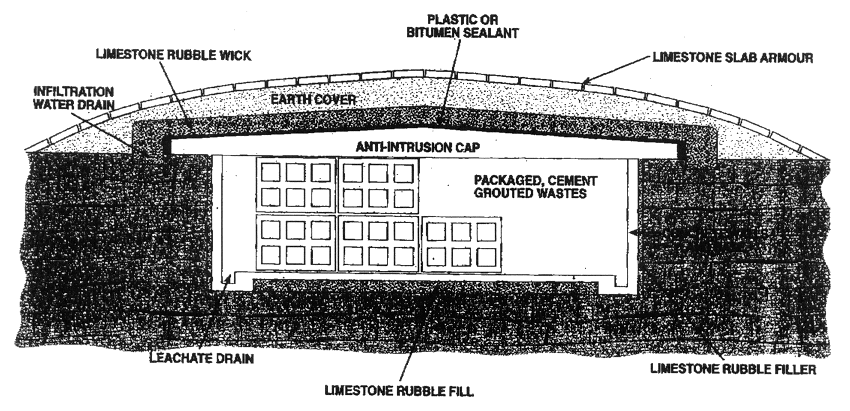
Considering an emplacement efficiencies for waste packages in the repository of 0.5-0.75 (volume waste package/total repository volume), the requirement for a disposal volume of around 330,000 m3 indicates that, for vaults which are 20 m wide and 5 m deep, a total of 16.5 vaults 200 m in length would be required. A disposal depth (from underside of cap to vault floor) of 5 m represents a reasonable operational size for waste emplacement, considering the incertitude on the height and movement of the water table at this stage. The outline suggested vault design is shown in Figure 1, where the below-grade option is illustrated, as this would provide the smallest space requirement.
Fig. 1. Repository design option
The basic features are:
The waste is considered to be stabilized in ordinary shipping drums using grout, since that seems to be the current standard practice based on the current inventory data. These drums should then be considered to be grouted into concrete overpacks, and emplaced in the vault. The space between emplaced overpacks could also be filled with cement grout.
Clearly, there is scope for cost optimisation when detailed design studies are carried out. At the time of closure, the vault should be covered first with a concrete cap (intrusion barrier) and then with a multiple layer cover, which is designed to provide lateral flow of water around the vault. A vault constructed in this way will provide essentially a monolith of cement and concrete, which minimizes the need for a leachate drainage system, and reduces the likelihood of intrusion. It is envisaged that a leachate collection system will be used during the operational and institutional control periods, but that the leachate collection system will be sealed after institutional control is relinquished.
S2
The suggested design for this site is an entirely below-grade vault, with thin concrete walls, a concrete anti-intrusion roof slab and a composite cover. Unlike S1, the vault could be excavated from the native limestone, using standard quarrying methods.
Concrete vault walls would be used simply to provide conformity of waste package emplacement. A thin limestone rubble backfill between vault walls and limestone host--rock would act as a lateral water flow deflection barrier, but this is not considered to be as significant an issue as at S1 These features should be the subject of a more detailed optimisation study at a later stage, and it may be shown that some redundancy exists. Owing to the good bearing capacity of the limestone, this facility design will only require a thin concrete floor to facilitate the installation and operation of the leachate drainage system. This would be emplaced on a graded limestone rubble base.
The composite cap has the same structure as that proposed for S1, except that the gravel layer is replaced by crushed limestone rubble. The function is identical. The upper earth layer may need to be imported from offsite and is consequently thinner than at S1. Instead, the suggested design makes use of some of the quarried limestone blocks to provide an upper armoured layer, to help minimise potential cap erosion in extreme precipitation events. It should be borne in mind, however, that such armouring might constitute an attractive resource once the site control is removed. The outline design is the same shown schematically in Figure 1 above. Again, this structure will need to be optimised at a more detailed stage of evaluation.
The space requirements, again assuming vault dimensions of 20 m x 200 m x 5 m, would be similar to those for S1. The site area is of the order of 100 hectares, of which at least 60 hectares are flat-lying. It is understood that additional flat-lying land, away from the scarp edge may also be available. Consequently, space is not a problem in accommodating the waste inventory.
Clearly, there is greater scope for having deeper vaults at this site. Construction of vaults up to 10 m deep should present no problems. This would reduce space requirements (although this is not a major issue at this site) and may also reduce costs. There is also the scope to have different designs for some parts of the repository; for example if additional intrusion resistance were sought for some classes of wastes by having deeper or more engineered vaults designs. Again, optimisation against a more detailed waste inventory and against the results of a full site characterisation programme will be essential.
The same approach to waste grouting, emplacement and operational shelter design, discussed above for SI also applies to S2 repository site.
PERFORMANCE ASSESSMENT
A preliminary safety assessment calculations have been performed on the repository systems proposed for the S1 and S2 sites. The objectives of this assessment are:
- to provide a preliminary evaluation of the suitability of each site for the near-surface disposal of low-level radioactive waste, and to provide data to allow comparisons between the two sites, in terms of repository performance.
- to identify key sensitivities and questions which would need to be answered by more detailed site characterisation and assessment studies.
- to handle a test case in order to achieve a tool for evaluating other sites.
Calculations have been made using the AMBER code, a flexible compartment calculational tool developed by QuantiSci using object oriented biosphere (OOBIO) class libraries (Brice 1996; Mortimer and Watkins 1996). Its design function was to calculate transfers (thus doses) of radionuclides in the biosphere, especially in foodchains, and is readily adapted to the problems to be modelled here.
The total radioactive inventory considered for the performance assessment calculation accounts for a total beta/gamma activity of 7.70 E+6 GBq, and a total alpha of 4.99 E+4 GBq.
A dose constraint of 0.3 mSv in a year is suggested for normal scenarios, applying to adult members of relevant exposure groups.
A risk constraint is suggested, applying to members of the exposure group associated with the disturbance scenarios. The risk is calculated as the product of the dose, the probability of exposure and the probability of fatal cancer arising as a result of the exposure. The latter quantity is taken as 0.5 per Sv and applies to a typical population [ICRP,1991] rather than particularly radiation sensitive individuals. Accordingly, the risk constraint is {1.5x10⁻⁵ per year}, and refers to a risk of death.
As a basic assumption for the assessment, reference is made to Figures 1. For the purposes of the simplified assessment, the two designs reduce to very similar major components of the engineered barrier system and can be considered to be effectively identical. Consequently, most of the assumptions which have been made apply equally to each type of repository.
With respect to credit assigned to specific barriers, the main function of the cover system is to divert precipitation away from the repository, thereby maintaining a low flux of water through the wastes, governed by the permeability of the cement/concrete vault walls and backfill. The hydraulic conductivity of intact concrete may be taken as 10E-12 m/s and the time to failure is normally considered to be in the range 200--300 years. After this time, water from precipitation is assumed to flow through the repository in the same way as natural recharge through soils or the ground surface. Thus, for an initial period, the rate of flow of water through the repository will be governed by the permeability of the concrete.
In terms of long-term protection from water and the consequent leaching of radionuclides, no credit is given specifically to the wasteform itself. Rather, the combination of wasteform, concrete vault lining and cap is taken as a basis for justifying a minimum failure time of 300 years.
A leachate collection system is included in the repository design which, during the institutional control period, would ensure that no radionuclide migration occurs from the repository into the unsaturated zone. However, in view of the uncertainties concerning how such a leachate system would be maintained after the withdrawal of controls, no long--term credit is taken in this assessment for a leachate diversion and collection system.
In general, three basic scenarios are normally considered when evaluating the suitability of a near-surface repository system:
The important exposure pathways to be considered fall within a general water pathway which comprises:
In this paper the overall discussion, assumptions and results of the preliminary performance assessment cannot be obviously presented. A significant result is given in Fig 2 and Fig. 3, giving the total annual dose to individuals as a function of time for the two sites and for the base-case scenario (drinking water pathway). Also shown are the key radionuclides contribution as a function of time.
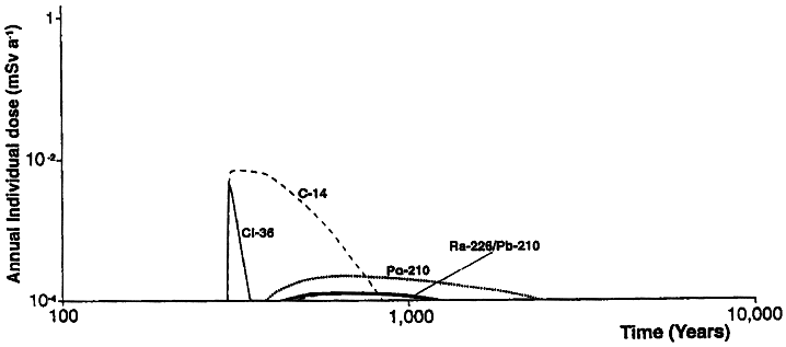
Fig. 2. Total annual dose to individuals as a function of time for the Site 1, plotted by key contributing radionuclide: base-case scenario - spring drinking.
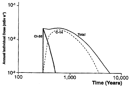
Fig. 3. Total annual dose to individuals as a function of time for the Site 2: base-case scenario - drinking water pathway. Also shown are the key radionuclide contributions as a function of time.
REFERENCES