DOUBLE CHALLENGE FOR HUNGARY IN RADWASTE MANAGEMENT
P. Ormai, f. Frigyesi
Paks Nuclear Power Plant Ltd., Paks
P.O. Box 71, H-7031 Hungary
O. Pavlik
Hungarian Atomic Energy Authority, Budapest
P.O. Box 676, H-1539 Hungary
Z. Balla
Geological Institute of Hungary, Budapest
Stefánia 14, H-1143 Hungary
L. Kovács
Mecsek Ore Mining Company, Pécs
P.O. Box 121, H-7614 Hungary
ABSTRACT
The main findings of two national programmes with special emphasis put on the unique approaches and features are summarized as follows.
In 1992, after two previous siting attempts had ended in failure, a National Project was launched aiming at establishment a repository for L/ILW. The key feature of the siting process is voluntary participation of communities. Between 1993-1995 some 300 geological objects were identified as potentially suitable for either near-surface or subsurface disposal. Boreholes were drilled at two near-surface (loess) sites and one subsurface (granite) site. Priority was given to the subsurface disposal in granite terrain where further site investigations studies have started in the middle of 1997. The decision on the suitable site, following which detailed characterization can start, is scheduled for 1999.
Since the break-up of the Soviet Union, Hungary met difficulties in disposing of spent fuel after discharge from the reactor. Hungary elected upon a strategy which still kept the Russian route open but which guaranteed an alternative means of maintaining operating capability.
Because of the geology of Hungary, only a limited number of potentially suitable disposal sites for HLW are available within the country. One of these is Permian claystone, a geological formation covering some 150 km2 in thickness of about 900 m. Preliminary studies were completed in the framework of a short-term characterization programme between 1994-1997. Decision is to be made soon on the continuation by starting a long-term characterization programme or to opt for other potential host rock media.
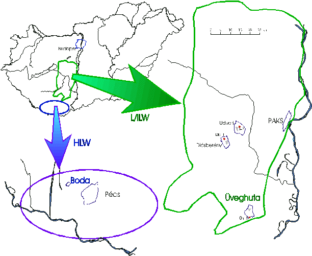
Paks Nuclear Power Plant, with its four VVER-440 reactors, generates approximately half of the nation's electricity. It is therefore imperative that the country has a secure fuel and radwaste disposal route. In Hungary the disposal capacity currently available ensures disposal of institutional wastes for many decades, but for L/ILW coming from the nuclear power plant a new facility should be built. Disposal of operational and decommissioning LLW and short-lived ILW is planned at the same site and in the same depth. Long-lived ILW is anticipated to dispose of together with the HLW.
It was found that the most appropriate means to achieve the basic objective was the establishment of an inter-departmental project in which all the organizations concerned would be involved. This was the National Project launched in 1992 by the Government. A Task Force was established to coordinate the tasks aiming at selecting site to dispose of L/ILW radioactive waste of Paks Nuclear Power Plant origin. Basically, the National Project aims at establishing a repository for L/ILW in a two-step approach, i.e. provide a basis for decision on the siting of the facility, then construction and operation of the facility. The siting in turn is being performed in two phases described below.
In the early stage of the project the strategy was approved to study alternatives both for disposal method and for location of facility. It was agreed that on-site investigations would only start in case of voluntary acceptance by the communities concerned. For site exploration the objective was the whole of Hungary up to the depth of 300 m.
The method used in site exploration was one of gradual approximation, whereby the exploration was performed in stages, thereby limiting more expensive investigations to progressively smaller areas. The geological exploration has been carried out by the Geological Institute of Hungary in four stages:
These stages are described below.
1st Exploration Stage
In the first step of the exploration (negative screening) on a scale of 1:500.000 all areas were ruled out that have to be protected from geological, political, economical etc. consideration, or where the disposal site has to be protected from industrial or natural influences. Site could not be chosen in a 30 km safety strip along the border, in areas of flood or overflows, within earthquake populations and zones of potential movements upon young faults.
Out of the 93 000 km3 area of Hungary about 6000 km2 was worth doing more research for near-surface, 23 000 km2 for subsurface disposal.
That step was followed by positive screening or area selection. Most important requirements were uniformity of rock masses, their great thickness and low hydraulic conductivity. Suitable objects were expected in areas where the number and density of potential geologic objects proves to be high. The area with the most potential is situated within an approximately 5000 km2 region as shown in Figure 1.
Fig. 1. Candidate Areas for Radioactive Waste Disposal in Hungary
2nd Exploration Stage
Both the negative and positive screening were repeated for the region designated with the help of much more detailed information on a scale of 1:100.000. Positive screening with criteria similar to those in the previous stage resulted in numerous prospective objects. 128 of these were near-surface and 193 for subsurface disposal including one granite object. Sedimentary objects of both types were listed and ranked separately.
The fundamental aims of all actions, events and programmes have been to establish a long-term relationship between the local community and to keep the local residents continually interested and confident in the development. After the screening letters inviting indications of interest were sent to all interested municipalities. The objective was to invite communities to volunteer their locality as a potential site.
After the checking public acceptability of sites only 12 near-surface and 18 subsurface objects (including the granite) remained.
3rd Exploration Stage
Stage 3 investigations were based on the idea that all exclusion criteria were valid and should be continually checked and rechecked. This process becomes easier with the reduction of suitable areas. However, the increasing volume of data from different sites become less suited to standard treatment, and local factors had to be increasingly taken into account in the evaluation.
In the chosen areas field studies were started to determine the site suitability. The emphasis was put on checking the fulfillment of geological and hydrogeological requirements such as:
Hydrogeological cross-sections ¾ with hydraulic conductivity data for different formations related to the recharge ¾ served as a basis for numeric flow modeling to estimate return periods.
4th Eploration Stage
On the basis of the scientific investigations, preliminary safety analysis and economical studies the Task Force selected three candidate villages where on-site investigations were started, additional three were kept reserve.
Field reconnaissance for disposal was started in two sites for near-surface disposal in loess, and in one for subsurface disposal in granite. Data on the subsurface sedimentary objects were analyzed more widely and more intensively than previously, and it was concluded that further studies even on objects with public acceptance should not be undertaken.
In next step, boreholes were drilled in three potential objects, and the data from them were widely studied. The drilling was performed under quality assurance and round-the-clock technical control so that the results can pass any international tests. In all boreholes geophysical well logging by a wide spectrum of methods was performed.
Granites have been studied and are regarded as a potential host rock in a number of countries which have abundant and diverse methodological experience. On the contrary, loess is generally regarded unsuitable for the disposal. Disposal in loess has been opposed by a number of Hungarian professionals as well.
The investigations carried out in 1995-1996 bore much higher return periods for granites than for loess. Simultaneously, granite features symmetrical and stable migration pattern. All these arguments served to promote the granite at Üveghuta site (see Figure 1).
However, the symmetrical migration pattern and high return period received for granite can be due to the fact that there was a lack of data and therefore it was necessary to suggest a homogenous rock body for calculating purposes. It was also clear that the granites bear fractures and are not everywhere impermeable like in the borehole.
The investigations above closed the first phase of the National Project, and their results formed the basis for designing studies for the second phase.
The second phase of the National Project consists of three stages:
These stages are described below.
1st Exploration Stage
The first stage consisted of geological evaluation of five areas in the neighborhood of the Üveghuta borehole. This first stage comprised detailed hydrogeological reconnaissance, geophysical survey and drilling (15-80 m). It was completed by July 1997, and the site designated as No. 4 at a groundwater watershed was selected for studying in Stage 2.
2nd Exploration Stage
The second stage comprises drilling of three boreholes to 300 m depth and one to 500 m depth. The boreholes are drilled by use of insert diamond bits, their spacing is 200 m. The boreholes are fully cored and logged by wireline geophysical methods. Borehole televiewer has been added to the standard suite of geophysical tools used in 1996, and this permits three-dimensional definition of fracture orientations. Core scanning by a newly constructed, portable Hungarian equipment gives detailed information on the texture and tectonics of the rock mass, and in combination with televiewer data offers a way to orient this information in space. Single-hole hydrodynamic testing is performed by Golder Associates in each borehole to determine fresh-water heads and formation properties. The completed wells will be instrumented for long-term monitoring (water-sampling and pressure-measurement) system.
Reflection and refraction seismic survey, horizontal tomography from the surface and shallow boreholes, velocity and absorption crosshole tomography as well as downhole seismic profiling are in progress to better determine the rock massif structure.
The Stage 2 fieldwork is to be completed in February 1998, and reporting on the studies as well as developing safety assessments will be completed in September 1998.
3rd Exploration Stage
On completion of the 1997-98 investigations and interpretation of their results a further safety assessment will be performed, and this will form the basis for the decision to be made concerning the suitability of the selected site for a subsurface repository for L/ILW and whether it merits further, more detailed, site characterization (stage 3). The latter will be carried out with the PHARE Project No. 4.09/94 support in 1998-99, its contents being under discussion.
Detailed site characterization will be followed by final safety assessment, environmental studies, designing and licensing process. The repository is planned to start operation in 2004.
Fuel for Hungarian NPP just as for all other East European VVERs was in the past supplied by the Soviet Union. As a part of Hungary's agreement on fuel supply the Soviet Union was obliged to take back and dispose of all spent fuel (another supplier would have left Hungary with the problem of high level waste disposal).
In 1995 the likely interruption of the spent fuel disposal route lead to a fairly immediate problem in Hungary. The spent fuel ponds became totally full by the end of the 1995 refueling. It was therefore necessary for a route for removal of fuel from the ponds to be implemented before the 1996 refueling to avoid the necessity to shutdown the reactors.
The decision was to build an interim store to hold spent fuel after it had completed 5-year cooling in the ponds. At some point in the future the fuel would either be packaged for direct disposal or reprocessed outside Hungary, and the vitrified high-level waste returned to Hungary for disposal. The first module of the Modular Vault Dry Store based on the GEC Alsthom design was licensed in early 1997.
As insurance against the waste remaining in Hungary or being returned after reprocessing it was highly desirable to proceed by planning for possible disposal of spent fuel some 50 years or more in the future.
The preparatory works were carried out in the framework of the L/ILW National Project, but since 1996 all activities have been conducted in a separate programme, called National Programme.
Site Investigation
The investigation has started by studying of the geological formation named Boda Claystone Formation (BCF), located on SW-Hungary, west of the city of Pécs (see Figure 1). The reasons for the site selection without any preliminary, countrywide screening were as follows:
The works aimed at the qualification of BCF proceed in good investigation situation because of favorable geometry. The BCF is a sedimentary rock formation of Late Permian age, which is known from more than 150 km2 area. Inside the 50 km2 affected by detailed investigation, its stratigraphical thickness is between 700 and 900 m, as verified by boreholes. The entire depth range can be studied simultaneously, and with its relations, between the surface exposed area of 14 km2 and the exploration tunnel system developed in the average depth of 1050 m from the surface, the most abundant information can be obtained. The spatial variability of parameters, among them the depth dependence , can be described numerically. Using surface and drilling research methods, the investigation can be extended to the formation underlying BCF as well.
On the basis of large-scale geological, sedimentological and tectonic habit of the area, the main features of major rock units, potentially selected for HLW disposal and of those studied in the exploratory tunnel, are identical. On the basis of recent investigations the upper 500-600 m thick part of BCF can be primarily suggested for further investigations. The exploratory tunnels and boreholes drilled from them affected the 400 m thick part of Boda Formation adjacent to the overlying beds.
The exploratory tunnel and the boreholes made it possible in a relatively small region to study in situ almost every rock varieties located on the contamination pathway and having different geological, hydrogeological a geotechnical features. The features of stratigraphical and tectonic boundary between the sandstone and siltstone, of the tectonic boundary zone and of the siltstone stressed tectonically in different degrees are determined in numerical form. Owing to the orientation of tunnel system, detailed anisotropy studies are carried out.
The investigation plan aiming at the qualification of geological suitability of the site is constructed ¾ with the help of AECL ¾ in such a way that the results of studies are usable for answering the following main questions:
Results so far indicate that the BCF is a strongly oxidized, thin- and thick-bedded, predominantly reddish brown sedimentary formation of chemical-clastic origin and of great thickness, built up of fine-grained, microcrystalline rocks. It can be ranged to the group of clay-type host formations on the basis of its mineralogical-petrographical composition and isolation behavior. One of the characteristic components of the consolidated, albite-bearing claystone-siltstone rocks representing the predominant mass of the formation is the non-swelling illite-chlorite clay mineral assemblage, having considerable isotopic absorption capacity because of its great specific surface. This effect is increased by the presence of disperse ferric oxi-hydroxides. In the weathering zone and in the tectonically crushed, crumbled rock material the illite transforms back to swelling clay mineral (montmorillonite). In the vicinity of fault zones the stress field ceases relatively quickly therefore the self-sealing of flow pathways formed by tectonic movements occurs as well. The smaller discontinuities caused by the formation conditions are filled with materials (predominantly carbonates) precipitated from solutions, which close the flow pathways growing together with the matrix material. The formation is built up of strata-cycles of different composition and of different mechanical and hydrodynamic properties originated from the seasonalvariations in the sedimentary environment.
As a consequence of the above-mentioned issues, the water system in siltstones is of logging, migrating character. The entire studied area is a regional infiltration area, there is no sign of ascendant waters. The pore and fissure waters of rocks show reductive conditions which are favorable from the point of view of transport processes. The study of the position and distribution of uranium anomalies emigrating and originating from the uranium ore deposit, developed in a geochemical trap, is an excellent possibility to make the knowledge on the regional flow directions more accurate.
The recent data from the comprehensive geological research project have shown that, as a result of geological structure and history of the area, no site-specific risk factor can be given regarding the long-term stability features of the area (recent tectonic activity, seismic events, slow crustal movements, erosion). The only site-specific risk so far recognized is the effect of mining activity. Therefore, research objects connected to the uranium ore mine cannot be used for final disposal. The dimensions of the formation make it possible to develop the repository in safe distance from the zone affected by mine cavities.
The final report evaluating the results of the preliminary HLW investigation programme is expected to be ready at the second half of 1998. The geological suitability regarding the final disposal of HLW cannot be decided surely in this phase of investigation. Professional and organization tasks to be solved by the ongoing investigation project include among others:
In spite of the insufficiencies listed above, it is a remarkable result that no reason excluding the suitability can be found after intensive, purpose-oriented studies using in situ methods and including the most considerable tectonic zone of the region.
For the moment, the further schedule of investigation is uncertain because of the termination of production of uranium ores. Principally, in spite of the mine closure, possibility is given to maintain the research object for a long term, and even ¾ on the basis of the features of BCF and of the tendencies of site selection unfolded recently ¾ to operate as an international reference laboratory in case of appropriate interest.
It has been verified that the nationwide approach to the L/ILW disposal in Hungary is effective. Geological studies in combination with voluntary acceptance by the local communities have resulted in a granite site at Üveghuta (southwestern Hungary). The site characterization is now in progress, and it seems possible to fulfill the governmental demand on a repository by 2004.
Exploration of the Boda Claystone Formation from the existing uranium mine cavities resulted in a conclusion that a large rock mass seems to be suitable for HLW disposal. Due to the closure of the uranium mine and great depth of the exploratory tunnels the repository can only be constructed elsewhere within the same rock mass, and much additional studies are needed to select and characterize the proper site.
1. Z. Balla, "Site Exploration for Low and Intermediate Level Radioactive Waste Disposal (1993-1996)", Annual Report of Geological Institute of Hungary, 1996/II, pp. 27-45, (1997).
2. P. Ormai, I. Czoch, Z. Balla, and K. Bérci, "Site Selection Procedure for LLW/ILW Repository in Hungary", Symposium on Experience in the Planing and Operation of Low Level Waste Disposal Facilities, Vienna, Austria, IAEA-SM-3411/32, pp. 203-213, (1997).
3. P. Ormai, F. Frigyesi, Z. Balla, J. Solymosi, and I. Gresits, "Low- and Intermediate-level Waste Repository Site Selection Process in Hungary", Radioactive Waste Management and Environmental Remediation, ASME Conference, Singapore, (1997).
4. P. Ormai, F. Frigyesi, I. Benkovics, L. Kovács, J. Csicsák, Gy. Majoros, G. Érdi-Krausz, and Gy. Bárdossy, "Hungarian Approach for Final Disposal of High Level Radioactive Waste", Geological Problems in Radioactive Waste Isolation, Second Worldwide Review ed. P.A. Witherspoon, Berkley, California, LBNL-38915-UC-814, pp. 113-123, (1996).