STATUS OF THE UNDERGROUND LABORATORIES
FOR RESEARCH ON THE GEOLOGICAL DISPOSAL
OF LONG-LIVED RADWASTE IN FRANCE
Y. Kaluzny, N. Sugier and M. Jorda
Agence Nationale pour la gestion des Déchets RAdioactifs (ANDRA)
1/7 Rue Jean-Monnet
92 298 Châtenay-Malabry Cedex FRANCE
ABSTRACT
Following a first fruitless attempt in the 1980s to build underground laboratory anticipating repository site, a law was passed by the French Parliament dated 30 December 1991 providing a fifteen-year framework for all the work to be done on the future of long-lived radwaste. This law promotes the search for a consensus between the political players, the technical players and the populations concerned by a future repository. It gave ANDRA its present status. It also entrusted ANDRA, with very precise attributions, to build and operate underground research laboratories designed to enable the Government to rule in 2006 on the feasibility of a geological repository and on the timeliness of such a repository compared with two other alternatives: separation/transmutation and near-surface disposal. After naming a mediator to develop a local consensus in the French Départements offering favoring geological formations, the Government, in January 1994, authorized the start of preliminary surveys from the surface, in four of the areas: Haute Marne, Meuse, Vienne and Gard. These involved geophysical measurements from the surface, boreholes, corings followed by analyses and laboratory measurements, and in situ hydraulic measurements, the results of which are presented here. The surveys, which spread from January 1994 to March 1996, served to confirm the quality of the formations anticipated and to pinpoint the ideal location for a future underground laboratory. They also served to prepare the administrative files for each of the three sites (Haute Marne and Meuse gave only one site: the East site, at their common limit), and to file them with the supervisory Ministries in mid-1996, according to the initial schedule. Based on these files and after their examination, the Government will decide in late 1997 on the construction of one, two or three laboratories. The various territorial authorities on each of the sites have voted broadly in favor of constructing a laboratory. The three public enquiries conducted in the first half of 1997 all secured a favorable consensus. A response from the Government is therefore anticipated, through a Decree of the Council of State, in 1998.
INTRODUCTION
In the 1960s, France became concerned with the ultimate disposal of the radwaste generated by the large-scale use of nuclear energy and radioisotopes. By way of example, it accordingly pressed on with the development, to the operating stage, of the near-surface disposal of low- and medium-level short-lived waste and the vitrification of high-level long-lived waste produced by spent fuel reprocessing.
An ambitious program to investigate the possibilities of geological disposal was accordingly undertaken in the late 1970s. In 1985, this program led the Government to request ANDRA, an organization reporting to the CEA at the time, to find candidate sites.
Following a first fruitless exploration of four sites containing potentially favorable geological formations (granite, clay, salt, shale), due to the growing opposition of the population of the areas concerned, the French Government decreed a two-year moratorium in early 1990. This interval was exploited to reflect on the causes of the failure, to develop a new approach, and to incite a parliamentary debate.
The debate in question culminated in the passing of the law of 30 December 1991 which provided a fifteen-year framework for research to be undertaken on long-lived radwaste management. This law clearly identifies ANDRA's attributions and altered the status of the Agency by raising it to the rank of a Public Establishment of an Industrial and Commercial Character (EPIC, Etablissement Public à Caractère Industriel et Commercial), independent of waste producers, placed under the triple aegis of the Ministries of Industry, Research and the Environment. When this period elapses, hence in 2006, the French Government, based on the summary report to be presented to it on the research results, will decide whether or not to start the construction of a geological repository and the relevant conditions. This decision, pursuant to the law of 1991, must necessarily be the focus of a new parliamentary debate and a new law.
THE LAW OF 1991, THE SEARCH FOR A CONSENSUS OF SOCIETY
After the 1991 law was passed, a new approach to radwaste management emerged, which could extend to the other major questions pertaining to environmental management. This approach is primarily based on the recognition and acceptance by each of the players of its own role and that of the others:
This implies in particular that the scientists and technicians innately believe in the role and responsibilities assigned to elected officials and in the capacity for judgement of the citizens. This also implies that the elected officials have the courage to set forth all the challenges, including those which will extend far beyond electoral dates and considerations.
A first characteristic of the law of 30 December 1991 is to deal, over a long period, with an uncertain area in scientific terms: today, even if the technicians have ideas on the different alternatives for high-level long-lived radwaste disposal, it is evident that many uncertainties subsist on the manner in which to design the repository and to demonstrate the absence of any environmental detriment. Rather than making a choice immediately, one of the main innovations of the law was to give the different parties involved a period of fifteen years to explore three research alternatives in depth:
This will require the Parliament to pass a new law when it decides, in 2006, after examining the three research alternatives, on further action on research and, subsequently, the creation of a disposal center.
A second characteristic of the law pertains to the means provided to the French MPs to obtain precise and also comprehensible scientific information. The law set up a National Evaluation Commission (CNE, Commission Nationale d'Evaluation) composed of:
This Commission will be charged with preparing an annual report on the state of progress of research in the three directions, and on the progress achieved abroad in the area. It will be required to prepare the final summary report of 2006.
A third characteristic of the law resides in its concern with associating the population and the local officials in the process of finding solutions and of the ultimate decisions. The selection of the areas pinpointed for intensive prospecting, among all the French locations favorable to a geological repository, was made on the basis of representations by the territorial authorities (municipal, general and regional councils) which voted to host an underground research laboratory. The same authorities were again consulted, after three years of prospecting from the surface, when the time came to decide on constructing the laboratory. Over and above the opinions of these elected representatives, the population itself was consulted through the public enquiry accompanying the administration's examination of the Application for a Permit to Install and Operate an Underground Laboratory. In particular, by the year 2006, the same players will be associated in evaluating the results of the research and in the decision, if any, to construct a repository on the site deemed favorable.
In connection with the concern to seek the involvement of the local players, the law has a fourth characteristic, openness and transparency. The annual reports of the NEC are made public and discussed at a press conference. Besides, on each prospecting and subsequently underground laboratory site, a Local Information Committee (LIC) is formed, provided with operating and investigative resources. It includes State representatives, elected territorial officials, members of environmental protection associations, members of farm unions, representatives of professional associations, personnel connected with the site, and ANDRA. According to the law, the LIC is informed about the nature and progress of the work, as well as the results. It can be consulted on any matter pertaining to the operations of the underground laboratory which have any effect on the environment and the neighborhood. It can have hearings conducted as well as second analyses by approved laboratories.
PRELIMINARY SURVEYS
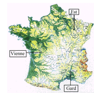
In late 1992, the Government charged the MP from the Nord Département, Christian Bataille, already the reporter to the National Assembly on the law of 30 December 1991, with a mediation mission. The aim, in the spirit described above, was to seek a local consensus and sufficient implication in the Départements offering geologically favorable formations. The mediator was asked to examine the situation in some thirty Départements. Four of them, the Haute Marne, Meuse, Vienne and Gard, declared their candidacy with the virtual unanimous support of their local elements. In January 1994, the Government authorized ANDRA, in charge of the second research direction set by the 1991 law, to initiate preliminary surveys accordingly.
These surveys confirmed the favorable character of particular sites over a sufficient area, sites capable of subsequently hosting an underground laboratory. This favorable character concerned the aptitude of the rock formation to contain, over the very long term (several hundred thousand years), the chemical species representative of the radionuclides present in the waste, as well as its geomechanical properties, allowing the completely safe excavation and operation of the underground cavities. It also presumed the local absence of any mining resources. Investigations were conducted with due consideration of the concerns expressed by the French safety authority (the Nuclear Installations Safety Directorate) in its Fundamental Safety Rule on geological disposal (RFS III.2.f, 1991). These concerns pertain to the tectonic stability of the sites and the hydrological, mechanical, thermal and geomechanical properties of the component rocks.
The surveys included geophysical measurements from the surface, boreholes, corings, followed by analyses and laboratory measurements, and in situ hydraulic measurements. They also offer the opportunity to gather the field data needed to compile the administrative files for the application for a permit to build and operate the underground laboratories. Naturally, favorable characteristics have to be confirmed in these laboratories.
Fig. 1. French Sites for URLs
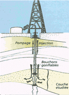
Fig. 2. In Situ Hydraulic Measurements
In Eastern France, on the margin of the Paris Basin and at the border of the Meuse and Haute Marne Départements, a favorable site was identified after examining the existing petroleum data followed by field investigations. The relevant formation, lying at a depth between 400 and 600 m, corresponds to Callovo-Oxfordian stage. It consists of an argillite composed of about 40 to 45% clay (interbedded illite/smectite), about 30% carbonates and 25% quartz. It is 150 million years of age and about 130 m thick. It is laterally homogeneous with a broad extension (> 100 km2), dipping uniformly northeast, as confirmed by the three deep boreholes (up to 1100 m). The formation is highly impermeable (10-12 to 10-14 m/s) and there are no aquifers in the horizons on either side of it. The regional geodynamic context is sufficiently stable to discount any seismic risk. The argillite has good retention capacities due to its very fine porosity (20 to 40 nm pores) and the cationic exchange capacity of its clay fraction (about 150 to 500 meq/kg). Its thermal conductivity, anisotropic due to the sedimentation in fine layers, ranges from 2 to 2.2 W/m per K according to the bedding and from 1.5 to 2 W/m per K in the vertical direction. Its mechanical properties closely follow the deposition conditions. Where carbonates are more abundant, the simple compressive strength is about 26 MPa, and, at the center of the formation, where they are more sparse, it is about 19 MPa. Given the mechanical properties of the rock, the usual civil engineering techniques could be used to excavate and support the galleries.
In west/central France, south of the Vienne Département, a favorable site was identified in a Hercynian granitic environment, after examination of the local gravimetric anomaly, revealing the presence of a granitic formation under sedimentary cover. The survey of eleven boreholes conducted in 1994 and 1995 showed the presence of a granodiorite deposited about 350 million years ago, at 450 m depth and over a thickness of several hundred meters. The analysis of the sedimentary cover, horizontal and relatively unfaulted, indicates a geodynamic stability of several million years. Its thickness, ranging from 150 to 180 m, includes two aquifers: the Lower Toarcian below and the Dogger above, separated by 20 m of Toarcian argillite. Hydraulic tests between seals, performed in 1996 in the granitic massif, revealed spaced water inflows (150 to 400 m) in fractures of certainly hectometric extension, judging from their thickness and relatively low transmissivity for this type of environment (10-6 m2/s). The volumes of rock lying between these fractures are intersected by small fractures clogged by calcite and clay deposits, probably more than 120 million years old and conferring low equivalent permeability (about 10-10 to 10-13 m/s) on the environment. The waters sampled in the fractures reveal a salinity gradient between a concentration of about 0.5 g/litre at the top of the granite, about 2 g/litre at 400 m depth, and 10 g/litre beyond. This salinity is estimated today to have originated more than 100 million years ago, connected with the tectonic movements which accompanied the opening of the Bay of Biscay. The clogging of fractures by very old minerals, the low frequency of water conducting fractures, the high impermeability of the rock matrix, the absence of a significant regional hydraulic gradient, and the ancient age of the waters, are all favorable hydrogeological properties, which nevertheless must be confirmed by measurements in an underground laboratory. The rigidity of the rock also makes the excavation, operation and reversibility of a subsequent repository relatively easy, and its thermal conductivity favors the removal of the residual heat and hence the compacity of a high-level waste repository.
In southern France, in the northeast of the Gard Département, a favorable site was found in 1994, after a cartographic reading, a first reflection seismic survey and a destructive borehole, designed to compensate for the few petroleum-related data. Investigations were supplemented by two cored boreholes and a second reflection seismic survey in 1995 and, in 1996, by a cored borehole to a depth of 1500 m. The Cretaceous formation found at a depth between 400 and 800 m is 200 to 400 m thick and dips northward. It dates from the Vraconian (100 million years). This silty formation, compact (porosity less than 10%) and highly impermeable (10-12 to 10-15 m/s), corresponds to a shallow coastal sedimentation zone where marine sediments accumulated (40% clay and 10 to 20% carbonates) together with continental debris (30 to 50% quartz), regularly mixed by animals and wave action. The formation is surrounded by two aquifer formations: the Cenomanian sandstone above and the Albian sandstone below. Despite the regional record of historic seismic activities of intensity VII (Nîmes fault), observations from the surface and within the formation itself failed to reveal any local vestiges of earthquakes less than 30 million years ago, associated with this fault. The geothermal gradient of 3 ° C/100 m indicates a stabilized geological situation. Examinations of the reflection seismic profiles clarified the erosion history of the Cèze and Rhône valleys after the 1800 m drop in the level of the Mediterranean Sea some 5 million years ago. The texture of the rock (10 to 20 nm pores) confers good retention capacity and high mechanical strength (40 to 10 MPa in simple compression), which are extremely favorable for a subsequent repository. Given the geometry of the formation (thickness, dip), it is proposed to excavate the laboratory on two levels.
APPLICATIONS FOR PERMITS TO INSTALL AND OPERATE
UNDERGROUND LABORATORIES
The scientific results obtained from 1994 to 1996 during the preliminary surveys conducted from the surface helped to consolidate and supplement the knowledge about the candidate sites for the construction of underground laboratories. None of the three sites revealed any features making it totally unfit for the construction of underground laboratories and, subsequently, possibly the construction of a repository. The French Government according instructed ANDRA in early 1996 to compile and file the statutory administrative applications for the three sites. For each site, these packages include an Application for an Installation and Operation Permit (DAIE, Demande d'Autorisation d'Installation et d'Exploitation) for an underground research laboratory, composed of some ten statutory documents. In addition to a memorandum which resumes all the geological and geophysical data acquired from the surface, the package contains an impact study, a hazard study and a laboratory specification.
The impact study analyzes the potential repercussions on the environment (air, fauna, flora, landscape) of the installation and operation of the laboratory, and suggests measures designed to eliminate or reduce its effects. The hazard study describes the risks (fire, flooding, explosion, gallery collapse) incurred by the laboratory, as well as the measures planned to reduce the probability and effects of any accident or incident.
The specification describes the laboratory and presents the research program to be conducted, as well as the time-table. It also describes the conditions for site remediation if the research conducted fails to confirm its suitability for hosting a repository. The research program, the raison d'être of the laboratory, includes two main categories of tests: tests concerned with characterization of the site, designed to confirm its favorable character definitively and hence its ability to accommodate a geological repository, and tests of a more technological order to clarify the procedures for constructing and operating a subsequent repository. Since they are the outcome of the preliminary survey programs described earlier, the research programs in the underground laboratories concerned with the supplementary characterization of the site are naturally specific to the site concerned.

Fig. 3. Core Examination
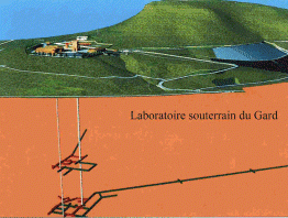
Fig. 4. Project of Gard Underground
Laboratory
In Eastern France, where the favorable character of the properties guaranteeing proper radionuclide containment is already firmly established, research will mainly focus on confirming the absence of faults and the low vertical hydraulic gradient between the formations surrounding the argillite layer, on the absence of mineral resources, and on the in situ geomechanical properties which guarantee the excavation of a repository, its operation and its reversibility, even after several decades of operation.
In the Vienne Département, research will naturally first focus on hydrogeology. The permeability of the rock formation will be clarified at different scales according to the degree of fracturing (from metric scale to multi-hectometric scale), the quality of the clogging of the metric fractures, and the connectivity of the hectometric fractures. The low hydraulic gradients will be checked. The chemical and isotopic composition of the granitic waters will be analyzed to date them more accurately and to guarantee the absence of communication with the waters of the two surface aquifers of the sedimentary cover, which are tapped for agricultural needs and for drinking water supply. In connection with the demonstration of tectonic stability, the laboratory will also allow a search for improbable traces of any past seismicity.
In the Gard Département, given the good mechanical and geochemical properties expected in the silty formation, characterization studies will mainly focus on the structure of the rock formation and the confirmation of the absence of seismic fracturing connected with the tectonic instabilities along the major regional faults (particularly the Nîmes fault).
The technological research program concerns the different phases of the operation of a subsequent repository: installation of the packages and retrieval, as part of the reversibility of the repository, installation and behavior of engineered barriers and seal materials. These studies, whose results will be consigned to the engineering packages for a potential geological repository, have already been outlined in different methodological or first generation laboratories, through international European cooperation (Mol in Belgium, Asse in Germany, Stripa and Aspö in Sweden, Grimsel in Switzerland) and foreign cooperation (URL in Canada).
The research programs in underground laboratories, whether for characterization or of a technological nature, will be developed during the construction of the laboratories and particularly during the drilling of the access shafts and galleries. These operations are an integral part of the full-scale testing, survey and qualification of the site, and will supplement the data provided by the preliminary surveys from the surface.
TOWARDS UNDERGROUND RESEARCH LABORATORIES
The three DAIE applications and the associated statutory files (building permit, declaration of public utility) were filed by ANDRA with the supervisory Ministries in the third quarter of 1996. The Nuclear Installation Safety Directorate having acknowledged the admissibility of these files, has requested the Préfets of the Départements concerned to expedite their examination. This is expected to last about a year. In fact, the applications must be analyzed by the administration services, both central and départemental, as well as the territorial authorities (municipal, general, regional councils). Besides, pursuant to the law of 30 December 1991 and subject to the law of 12 July 1983, the applications must be open to public consultation through a public enquiry on each of the candidate sites. The Administrative Tribunals concerned have therefore designated the Enquiry Commissions and the Inter-Préfectoral Orders empowered them on 31 January 1997, 9 January 1997 and 17 January 1997 respectively for the East, Vienne and Gard sites. These enquiries took place respectively from 3 March to 17 May, 3 February to 11 April, and 17 February to 17 April of the year 1997. The National Evaluation Commission will also issue a scientific opinion on each site.
So far, the different territorial authorities have expressed themselves by vote. The table below summarizes the positions of each.
Table I. Results of Votes of Territorial Authorities
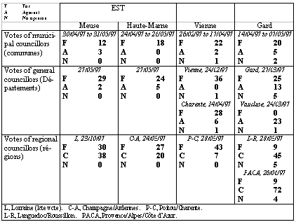
It may be observed that nearly all the territorial authorities directly concerned voted broadly in favor of the laboratory project, thus confirming the initial declaration of candidacy. The only exception is the Regional Council of Languedoc/Roussillon.
The three Enquiry Commissions have filed their report. These reports are all favorable to the installation of a laboratory on the site considered. The site investigating Commissioner for the East. site accompanied his approval with three reservations which in no way question the project concerned (clarification of the concept of reversibility, simultaneous effort in the three research directions prescribed by the law of 30 December 1991, study of the preservation of the memory of the site, in the case of a subsequent repository. The Commissioner for the Vienne site (actually the same) added similar recommendations. The Commissioner for the Gard site expressed no reservations.
The National Evaluation Commission, on the occasion of the publication of its third annual report in September 1997, presented its assessment on the advisability of continuing on geological radwaste disposal by the construction of the underground laboratories planned by ANDRA. It expressed a highly favorable opinion on the East. site, confirming its judgement expressed in its report for the previous year. It was favorable to the Gard site, considering the further efforts made by ANDRA in 1996 and 1997 on the continuity of the target silty formation, the seismo-tectonic context of the area and its hydrogeological environment, and on the consequences of the potential closure of the Mediterranean Sea and the concomitant drop in the level of its waters, causing a resumption of the erosion of the Rhône Valley. On the other hand, the Commission considered that the Vienne site, due to its intrinsic complexity, its hectometric fracturing (in view of a potential repository with a kilometric base hence demanding a very specific architecture remaining to be determined) and the risk of hydraulic connections between the granodiorite formation and the overlying aquifers, displayed negative aspects which appeared insurmountable today. ANDRA questions today this assessment. Moreover, it has to be noted that NEC assessment is not included in the Permit procedure.
The Nuclear Installations Safety Directorate still has to approve these different opinions for an ultimate proposal to the Government. The latter will also appreciate it in the light of the national political situation, including its energy and environmental concerns. ANDRA now awaits a decision to continue its research in one, two or three underground laboratories, pursuant to the Decree of the Council of State to be published in the first part of 1998.