LANDFILL REMEDIATION
U. S. DEPARTMENT OF ENERGY
GRAND JUNCTION OFFICE CASE STUDY
Brigitte S. Burns and John Elmer
IT Corporation*
Joseph Virgona (DOE Retired) and Michael Tucker
U. S. Department of Energy
Grand Junction Office
Grand Junction, Colorado
ABSTRACT
In 1981, the U.S. Department of Energy (DOE) Grand Junction Office (GJO) was assigned the Uranium Mill Tailings Remedial Action (UMTRA) Grand Junction Vicinity Properties (GJVP) Project. More then 4,000 properties in the Grand Junction, Colorado area were contaminated with radioactive uranium mill tailings as a result of milling operations conducted for the U. S. Government during the 1950s and 1960s. Congress passed the Uranium Mill Tailings Radiation Control Act in 1978 to authorize DOE to remediate and to permanently dispose of the radioactive mill tailings that were spread throughout the southwestern United States.
One of the most complex UMTRA sites is situated near the Grand Junction business district on the north side of the Colorado River. The former American Auto Salvage property consisted of approximately 27 acres of land with an inactive landfill on the site. Because of the possibility hazardous wastes would be discovered on this property, special precautions were needed for their management. Assessment activities included radiological, hazardous waste, and groundwater investigations. Special construction techniques were put in place to prevent the mismanagement of hazardous waste. During remediation activities, an unexploded ordinance, medical wastes, and polychlorinated biphenyl (PCB) ballasts were excavated and managed.
INTRODUCTION
Radioactive uranium mill tailings were remediated from more than 4,000 properties as part of the Uranium Mill Tailings Remedial Action (UMTRA) Project in the Grand Junction, Colorado area. One of the UMTRA sites, the American Auto Salvage site, consisted of approximately 27 acres. This site consisted of an inactive landfill that posed the potential for hazardous materials to be discovered on the property. Because of this potential for hazardous wastes on the property, assessment activities for radiological, hazardous waste, groundwater investigations were put in place. Special construction techniques were also used to prevent mismanagement of the hazardous wastes.
Site Information
Historically, a portion of the American Auto Salvage property was occupied by a gravel pit operation. The gravel pit was located within an old river channel and was subsequently converted for use as a municipal landfill during the early 1960s. Landfill materials, uranium mill tailings, and tailings-contaminated material were alternately deposited in the former gravel pit. Historical information indicates that the site was used as an unsupervised, unpermitted, open-use dump and then as a municipal, and possibly hazardous materials, landfill during the early 1960s. Records also indicated that the landfill materials extend 10 to 12 feet in depth and are within the groundwater recharge influence of the Colorado River. An auto salvage yard and a radiator service facility occupied the site after the landfill was filled and made inactive. Two large city sanitary sewers (21 inches and 30 inches in diameter) cross the middle of the property.
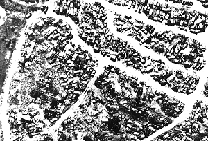
Figure 1. Site as an auto salvage yard and radiator service facility
The city of Grand Junction purchased the property in 1990 for use as part of the Riverfront Trail system and for the lower downtown Redevelopment Project. This property was considered the keystone of the Riverfront Trail system. Under the terms of the Remedial Action Agreement (RAA) among the city, DOE, and Colorado Department of Public Health and Environment (CDPHE), DOE made a payment of $655,000 to the city in 1990 in lieu of placing future backfill on the site. This payment contributed toward the city's purchase price of the property. The RAA also had a provision for the city to receive an approximate balance of $245,000 after remediation to reflect actual quantities of backfill not used.
On the basis of the historical use of this site and proximity to the Colorado River, an extensive amount of testing was performed to assess what obstacles could potentially be encountered during remediation. These assessments were directed at evaluating, 1) current land uses on the site and on adjacent properties, 2) existing environmental conditions on the site, including geology, topography, ecology, surface water, and groundwater, 3) current use, storage, handling, and disposal practices of chemicals and potentially hazardous materials on the property, 4) the presence of potential asbestos-containing materials, underground storage tanks, and fluid-cooled electrical transformers on the site and, 5) the extent of radiological contamination.
The city of Grand Junction contracted with a private contractor for a property transfer assessment report in 1990 to identify current and historical information about the site. [1] The report contains information about monitoring wells that were installed, radiological assessments that were performed, and subsurface soil samples that were collected. The city also employed a private investigator to determine if illegal dumping was performed on the site.
SITE CHARACTERIZATION
Radiological Soils
GJO personnel conducted a standard UMTRA radiological characterization of the property with surface gamma scans, downhole logging, and laboratory analysis of soil samples.[2] However, assessment activities were hampered because ongoing salvage yard operations restricted access.
Surface gamma readings ranged from 14 to 1,051 microrems per hour, and radium-226 concentrations in the soil ranged from 15 to 323 picocuries per gram (pCi/g). Radiological survey measurements used to determine the extent and depth of the uranium mill tailings estimated that contamination extended more than 10 feet deep in the landfill area. Of the approximately 170 holes drilled across the property for the radiological assessment, 130 holes were drilled in just the landfill. The depth of contamination in the landfill area varied because of the nonhomogeneous nature of the fill material, which also contributed to numerous auger refusals.
Commingled Waste Soils
Commingled waste is defined as uranium mill tailings mixed with a Resource Conservation and Recovery Act (RCRA) hazardous waste or PCB. Two separate Commingled Waste Investigations Program (CWIP) investigations were performed; one in 1990 and the other in 1992 with a total of 26 holes drilled. The first activity in 1990 consisted of investigations for volatile and semivolatile organic compounds (including PCBs and pesticides) to determine if listed hazardous wastes or discarded commercial chemical products were present within the tailings-contaminated areas. No concentration of volatile or semivolatile chemicals were identified above regulatory thresholds. Concentrations of the pesticides, lindane and heptachlor, were determined to be present above the laboratory-required quantitation limits. Because there was no known historical use of pesticides at the site, the analytical results either were anomalous or the concentrations are remnants (beta-BHC and heptachlor peroxide) of some unknown use of the parent pesticides. Neither concentrations (which are total concentrations) of these compounds exceeded the threshold values for the listed parent pesticides. Therefore, the isolated occurrence of these pesticides in the identified concentrations did not support a hazardous waste designation. The presence of the pesticides was probably the result of a drill auger encountering a small container of commercially available agricultural chemicals.
The purpose of the second CWIP investigation performed in 1992 was to provide screening data to determine if hazardous wastes had leached into groundwater and if hazardous wastes or hazardous gases were present in the vadose zone. Although the results of laboratory analyses indicated that the groundwater contained numerous metals and salts, most of the metals identified were the metallic ions associated with common salts, such as magnesium, calcium, potassium, and sodium. The types of constituents identified were consistent with those typically encountered in municipal landfill material, areas with desert-type (alkali) soils, and areas with a high water table and a high evaporation rate. The evaluation of the listed hazardous wastes and toxic substances analyses showed concentrations of either no detection or below regulatory limits.
Groundwater
The American Auto Salvage Monitoring Well Installation Project was initiated in April 1992 to provide an assessment of groundwater quality and quantity.[3] Results of the assessment would be used to determine options for managing construction water encountered during remediation of the mill tailings and tailings-contaminated materials in the landfill area. Seven holes were drilled for this project. Six holes were placed directly in the landfill and one was placed upgradient of the landfill to determine background water quality.
Volatile organic compounds detected in the first round of samples consisted of vinyl chloride, cis-1, 2-dichloroethene, trichloroethane, ehtylbenzene, m,p-xylene, and o-xylene. No semivolatile organic compounds were detected above the laboratory quantification limits. Pesticides identified were alpha-and gamma-chlordane. No herbicides were identified. Inorganic constituents identified include aluminum, antimony, arsenic, barium, boron, calcium, chromium, copper, iron, lead, magnesium, manganese, molybdenum, nickel, potassium, sodium, uranium, vanadium, zinc, ammonium, chloride, fluoride, nitrate, and sulfate. Other constituents identified above detection limits in the first sampling episode were radium-226, total organic carbon, total petroleum hydrocarbons, and molecular sulfur. The volatile organic compounds detected from the second sampling event were 1,2-dichloroethane, and cis-1,2-dichloroethene. No pesticides or herbicides were identified in the pumping test water-quality samples. Inorganic constituents identified were antimony, barium, boron, calcium, iron, magnesium, molybdenum, potassium, sodium, uranium, zinc, ammonium, chloride, fluoride, nitrate, and sulfate. Other constituents identified in the pumping test waste-quality samples were total organic carbon and molecular sulfur.
Exploratory Excavations (test pits)
A series of six test pits were excavated on August 1, 1994, to establish the boundary of the landfill and to obtain samples of landfill materials. Visual observation of test pit material indicated that the extent of the landfill was greater than anticipated. Materials observed in the test pits consisted of ash, organic matter in various stages of decomposition, tailings, and inert material such as cans and glass. No evidence of drums or signs of potential hazardous waste was observed.
Because the landfill materials were to be disposed as a U. S. Nuclear Regulatory Commission (NRC)-approved disposal cell, strict specifications had to be met for the types of material that could be placed in the cell. Concerns were raised about the organic content of the landfill material because of its effect on compaction and settlement. Soil tests were performed on the landfill materials to calculate the percent of organic matter. The average percentage of organic matter identified by weight was 3.22 percent.[4] This level of organic materials met the disposal specifications for the cell. However, the cell operator required that organic material be mixed as much as practical to avoid pockets of the organics that could not be compacted to meet compaction requirements.
ISSUES
Supplemental Standards
The use of supplemental standards had been considered several times as a remediation alternative for the property. EPA standards for remediation allow for use of supplemental standards that will result in nonremoval of radiological material if certain criteria are satisfied. Provisions in 40 CFR 192 allow for the use of supplemental standards based on characterization of the site.
Concerns were raised about opening a landfill, finding hazardous waste, and then being responsible for the waste. However, the GJO believed that the property had been adequately characterized. The decision was made not to apply supplemental standards because the criteria could not be met and GJO believed risks could be mitigated.
Permitting Process
Multiple permits were required to enable remediation of the site:
Mitigation of Risks of Managing Hazardous Wastes
Because of the potential to find hazardous waste on the property, DOE needed assurance that it would not inherit hazardous waste that it did not generate. From the characterization data and exploratory excavations, the boundary of the landfill could be established, allowing remediation of other portions of the site first. CDPHE policy was that if the hazardous waste were managed by DOE, it would be considered a generator under RCRA. DOE requested CDPHE to define "management" of hazardous waste. CDPHE responded with a definition that allowed DOE to proceed. If hazardous wastes were found, the following procedure was used:
GJO had to develop a methodology to identify hazardous wastes before they were moved off site. To ensure hazardous wastes would be identified before shipment, a double handling procedure was used. First, CWIP personnel trained and experienced in visually discerning a suspect hazardous material would have to be on site at all times and inspecting the excavations. Second, each equipment operator was trained on what potential hazardous material could be encountered on the site and how to discern a suspect hazardous material. This excavated material was hauled to a large stockpile adjacent to the truck loading area. Then, all the radiologically contaminated material was handled and inspected again as the material was being loaded into the haul trucks. Because of the uncertainty of what might be encountered and the resulting potential exposure to workers, the site was designated as a 1910.120 site for precautionary measures. This measure ensured no project stoppage if a hazardous waste was encountered.
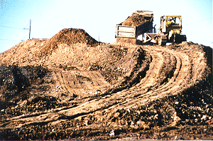
Figure 2. Stockpile used for double-handling contaminated material
REMEDIATION
Phased Approach
The remediation of the property began in 1990. The remediation was divided into four phases because of the complexities, regulatory time constraints, and the goal of trying to remediate as much as possible. The four phases are shown in Figure 3 below.
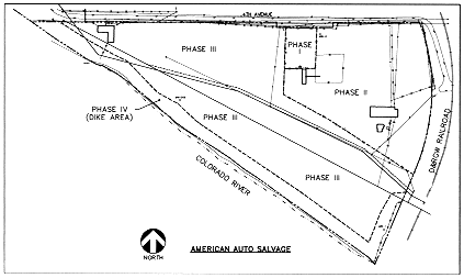
Figure 3. American Auto Salvage site showing separate phases
Phase I
Phase I, the 100-by 200-foot staging area, was situated so that haul trucks could have good visibility onto the haul route for oncoming traffic. The staging area consisted of a decontamination pad, support trailers, showers, and utilities. The staging area was remediated, then the site was fenced, and a 2-inch layer of gravel was placed. Four trailers were placed in this area: a construction office, a subcontractor office, a health and safety office, and a shower room to meet the requirements of a 1910.120 site based on the potential for finding hazardous constituents. A 20-by 70-foot by 6-inch concrete pad was constructed for decontaminating haul vehicles and equipment. The haul trucks were inspected for visible contamination, mechanical fitness, and secured tarps before leaving the site.
Phase II
Phase II included the removal of shallow surface contamination on the north and east portion of the site that did not include portions of the landfill and construction of an exfiltration pond. Remediating this area created approximately 5 acres of radiologically verified land that could provide room for an exfiltration pond and dewatering system.
Because of the depth of contamination of the site and groundwater saturating the tailings and tailings-contaminated material, a method for managing the groundwater was needed. The volume of groundwater to be encountered and the baseline groundwater quality needed to be determined. After reviewing the regulations and conducting discussions with CDPHE, a determination was made that a discharge back into the groundwater from an exfiltration pond was allowed. A 1-acre unlined pond area was excavated to manage future groundwater dewatered from the excavation.
Phase III
Phase III consisted of remediating the landfill. The first vertical 9 inches of radiological contamination were removed from the entire site to reduce the footprint of the contamination and to create a stockpile that could be used to blend with the landfill materials for better compaction at the disposal cell.
Two active sewer lines traversed the entire length of the property. The north line was an old 21-inch vitrified clay line serving a large basin east of Grand Junction. The south line was a 30-inch reinforced concrete pipe that served another large area south of Grand Junction. Portions of both lines crossed areas where excavations were expected to exceed the depth of the pipes. However, further assessment revealed that the 21-inch line was not contaminated with mill tailings and therefore not in need of remediation. A joint cost-sharing effort between DOE and the city was established to remediate the 21-inch line and re-route the 30-inch line around areas of contamination. The 30-inch sewer line was entirely rerouted to allow remediation of the former location of the line.
The excavation of the landfill area extended below the groundwater as anticipated. Because the subcontractor chose to open up large areas of excavation, the groundwater pumped from excavated areas was considerably more than the exfiltration pond could hold. A series of coffer dams constructed with clean pitrun material were placed across the excavation to minimize the effects of large volumes of water in the excavation at any one time. Subsequent to remediating contamination and radiological verification, 6 inches of fill dirt was placed over the entire site to allow us to meet our subsurface standards of <15 pCi/g of subsurface material and save considerable funds because of not backfilling to pre-construction grades.
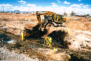
Figure 4. Excavation in Phase III, the landfill area
More than 15,000 tires were unearthed during remediation activities on the site. Each tire had to be cut into sections and decontaminated on the decontamination pad with a high-pressure wash to remove all visible soils and meet acceptance criteria at the county landfill. This effort cost more than $62,000.
Several types of wastes were encountered during the remediation and were disposed of on the basis of laboratory analytical results and disposal facility requirements:
Phase IV
Phase IV consisted of excavating mill tailings and tailings-contaminated material from the dike area. Remediation of the dike area was performed in such a manner that no material was dispersed into the Colorado River. Phase IV was a separate task because the COE-404 permit allowed construction along the Colorado River only between October 1 and June 30. This time frame was stipulated to minimize the impacts of the water quality during the spawning of a Threatened and Endangered fish species. The 404 permit also dictated special revegetation requirements for disturbed wetland and riparian areas.
PROJECT COSTS AND SCHEDULES
DOE-GJO received preliminary authorization from DOE Headquarters to proceed with the full scope of remedial action during the week of July 20, 1995. At that time, Phase I and II for this property had been completed but the remaining scope of work (Phases III and IV) had been on hold for at least 2 years. The original schedule for this property was 18 months; the project required the full duration. However, the original estimates in Phases III and IV for the volume of material to be remediated was 161,850 tons. When the project was completed, the total volume of remediated material excavated for these same two phases was 224,888 tons, a 39 percent increase.
CONCLUSIONS
Despite the concerns and risks associated with the remediation of an unregulated landfill layered with uranium mill tailings, the project was successfully completed and the valuable riverfront property returned to the community for redevelopment.
One of the greatest benefits from this project was the lessons learned from the planning and negotiating required to make it work. The number of assessments and exploratory excavations helped this project come together by alleviating concerns and minimizing the potential risks and assuring the stakeholders that the project was being performed in a methodical process. Double handling of the material was also of great benefit to the project. Although certain aspects of the project seemed too conservative, the State and the disposal site operators were more comfortable with the types of material being hauled to the disposal cell.
REFERENCES
* Work performed under DOE Contract No. DE-AC13-96GJ87335 for the U. S. Department of Energy