REMEDIAL ACTION AND UNRESTRICTED RELEASE
DETERMINATION AT A UNIVERSITY MEDICAL
RESEARCH FACILITY DISPOSAL SITE
P. Brandt
NFS, Inc.
ABSTRACT
The burial site is located in the Piedmont Region of the Southeast. The bedrock geology underlying the site is characterized by the presence of late Precambrian to early Paleozoic igneous and metamorphic rocks including schists and gneisses and to a lesser extent granite and quartzite. Soil depth varied over the site from six inches to over four feet. Bedrock was commonly overlain by a mantle of weathered bedrock or saprolite. The thickness of the saprolite varied over the site from zero to over eight feet. Bedrock, when encountered, was typically fractured. A perennial stream was approximately 200 feet down gradient from the site and approximately 50 feet lower in elevation than the lowest point in the burial ground. The burial ground was located on the side slope of a small hill just below the crown of the hill.
SITE HISTORY AND RADIOACTIVE WASTE INVENTORY
The landfill was operated under a state license from approximately 1960 to 1975. Based on historical documentation, waste included animal carcasses, scintillation vials and general laboratory waste from teaching and research activities such as test tubes, vials, plastic and glass. It was originally estimated that 3,000 cubic feet of material was buried in an area encompassing approximately 15,000 square feet. The decay corrected (January 1996) radionuclide inventory is shown in Table I. The majority of the inventory was the beta emitters H-3 and C-14 in milliCurie amounts. The remainder of the inventory was in microCurie amounts.
The mode of disposal was to accumulate a sufficient volume of material, transport the material to the site and excavate a pit eight to ten feet deep, place the waste into the pit and backfill the pit with clean material so that there was at least four feet of backfill over the waste material. No records existed as to the location of the pits. The general site location was indicated by signs and markers on trees. Scattered throughout the site were shallow excavations two to six feet deep and mounds of soils one to three feet deep.
The site vegetation included an over story of pine and hardwood trees and an under story of shrubs and blackberry vines. Trees within the designated burial ground appeared to be approximately 20 to 25 years old whereas trees along the perimeter of the site appeared to be much older (50+ years).
Table I. Inventory of Buried Radionuclides
RADIONUCLIDE |
EMITTER |
RADIOACTIVITY* |
| H-3 | Beta | 143 mCi |
| C-14 | Beta | 80 mCi |
| Co-60 | Beta-Gamma | 4.7 m Ci |
| Cs-137 | Beta-Gamma | 43 m Ci |
| Sr-90 | Beta | 40 m Ci |
| Na-22 | Beta-Gamma | 2.4 m Ci |
| Cl-36 | Beta | 100 m Ci |
| Ba-133 | Beta-Gamma | 36 m Ci |
| Am-241 | Alpha-Gamma | 10 m Ci |
| Ra-226 | Beta-Gamma | 1 m Ci |
*mCi - milliCurie;
m Ci - microCurieSITE ACTIVITIES
Identification of Background Location
A site was tentatively identified as a background site along the same topographical elevations as the burial ground. The background location had similar soil types, vegetation and bedrock as the disposal site.
Non-Intrusive Surveys
An area of approximately 15,000 square feet was roughed out as the background location. A square grid system was temporarily located in the field using surveyor's wire flagging. The grid points were approximately 10 feet apart. Each grid was systematically surveyed using a sodium iodide detector and an Eberline ESP-2. Two measurements were taken at each grid point: (1) one at one meter above the ground surface and (2) one at the near surface (approximately one inch above ground). A measurement consisted of total counts recorded over a one minute duration. A total of 164 locations were measured in the background location. In addition, two other areas were surveyed: (1) a nearby gravel access road and (2) the gravel bed of a nearby railroad. Table II summarizes the data results showing the minimum, maximum, mean and standard deviation.
Table II. Gamma Radiation Readings (Sodium Iodide Detector Survey)
Counts per/Minute - One Minute Count Time
BACKGROUND |
Min |
Max |
Mean |
Standard |
| Surface | 12,100 |
21,200 |
15,234 |
1,250 |
| 1 meter | 11,600 |
16,500 |
14,246 |
977 |
1 METER |
Min |
Max |
Mean |
Standard |
| Road | 12,100 |
14,700 |
13,508 |
795 |
| Railroad | 17,100 |
19,000 |
18,250 |
620 |
| Staging Area | 13,300 |
14,500 |
13,925 |
379 |
PRE-WASTE |
Min |
Max |
Mean |
Standard |
| Surface | 9,380 |
19,900 |
14,497 |
1,407 |
| 1 meter | 10,900 |
17,000 |
14,417 |
1,183 |
POST |
Min |
Max |
Mean |
Standard |
| Surface | 11,500 |
16,300 |
13,661 |
770 |
| 1 meter | 11,500 |
14,800 |
13,239 |
588 |
OTHER AREAS |
Min |
Max |
Mean |
Standard |
| Decon Pad | 13,100 |
17,400 |
15,475 |
1,209 |
| Graveled Area | 14,200 |
17,400 |
16,432 |
850 |
| No Gravel | 13,100 |
17,400 |
14,748 |
895 |
| Astronomy Pad | 13,000 |
23,100 |
15,476 |
1,864 |
| Gravel-No Waste | 15,400 |
23,100 |
18,017 |
1,813 |
| Waste-No Gravel | 13,000 |
18,700 |
14,688 |
960 |
Intrusive Sampling
Sampling sites were selected to provide information over a range of expected soil conditions and included taking samples from areas where the soil ranged in depth from zero to six inches to areas where the soil depth exceeded four feet. Where possible, soil cores were divided into four depth increments: (1) 0-6 inches, (2) 6-18 inches, (3) 18-36 inches and (4) 36-48 inches. A total of 29 samples (which included two field duplicates) were collected at seven locations and analyzed for gross beta as well as gamma activity at an off site laboratory. The location of the seven sample sites was surveyed in.
Identification of Burial Ground
The burial ground area was conservatively delineated based on historical (not to scale) sketches of the site, site markers, age of over story vegetation and indication of physical disturbances such as pits and piles of soil. The burial ground was in the shape of a trapezoid with the long axis approximately 300 feet long and the shorter axis approximately 100 feet long with a total estimated area of 26,000 feet which was approximately 75% larger than the original estimate.
Non-Intrusive Surveys
A 10 X 10 foot grid was laid out in the burial ground. A direct gamma radiation measurement was taken at one meter and at the soil surface. The same instrument and count times used for the background counting was used for the burial ground counting. A total of 261 locations were measured. Table II summarizes the data results showing the minimum, maximum, mean and standard deviation.
Intrusive Sampling
Sample locations were selected to provide coverage over the entire burial ground area in areas where it was not expected to find waste. Where possible, soil cores were divided into four depth increments: (1) 0-6 inches, (2) 6-18 inches, (3) 18-36 inches and (4) 36-48 inches. A total of 18 samples were collected (which included two field duplicates) at five locations and analyzed for gross beta as well as gamma activity at an off site laboratory. No waste was encountered during the sample collection. The location of the sixteen (16) sample sites was surveyed in.
Field Activities
Prior to field activities beginning, the customer informed NFS that possibly 30 or more 55-gallon drums of waste may have been disposed of in the burial ground. The waste consisted of debris waste from decontaminating a hospital that had performed radium cancer treatment in the 1930's. The exact volume, location of the disposal site(s) and Ra-226 inventory was unknown. Consequently, a magnetometer survey of the burial ground was initiated prior to the initiation of excavation activities. Six anomalies were identified and their locations marked for further investigation.
A qualitative radiological assessment was made of the burial ground using field instruments prior to any field activities. Based on the results from the qualitative assessment, underbrush and dead trees were cleared from the burial ground and mulched on site. After the underbrush was cleared, the site was systematically surveyed using a sodium iodide detector. Excavation activities were begun in April 1996. Due to topographical constraints and potential waste handling concerns, it was necessary to begin excavation on the north side of the property and work from north end of the burial ground to the south end. Initially a small trackhoe and backhoe were used for excavating. Exploratory trenches were excavated along lines that minimized the removal of healthy trees that had a diameter at breast height that exceeded six inches or more. However, as the work progressed from north to south the depth of soil and/or soft saprolite increased and it was necessary to add a much larger trackhoe with a bucket capacity of 2.25 cubic yards and an ability to excavate to a depth of 20 feet or more.
Waste, when encountered, was in pits and not trenches. The waste was bulk excavated and placed into B25 boxes (metal boxes approximately four feet by four feet by six feet). The volume of waste in each pit ranged from approximately 100 to 600 cubic feet. After the bulk of the waste (over 99%) was removed and containerized, additional soil was removed from the pit bottom along with any remaining debris and placed into 20 cubic yard roll offs. Initial trench spacing was such that that there was no more than one excavator bucket width between trenches. Ultimately an estimated 98% of the entire burial ground area was excavated leaving only those areas that were approximately one foot away from a chain length fence on the west and south ends of the burial ground un-excavated. In addition, an area of approximately 20,000 square feet outside the designated burial ground was excavated.
All excavations were conducted down to firm bedrock and/or undisturbed saprolite or regolith surfaces. Excavation depths ranged from two to eighteen feet. Field screening of the excavated material was conducted using alpha, beta and gamma measuring instruments and photo ionization detectors (PIDs) and Dreagger tubes for organic surveys. Waste streams were initially segregated into three waste streams: (1) excavated debris waste which was placed into B25 boxes, (2) suspect contaminated soil from pit bottoms with a small percentage of debris waste and (3) animal carcasses. Approximately 8,000 cubic feet of waste (80 B25 boxes) were exhumed from the original burial ground. The last waste stream consisted of an estimated 3,000 pounds of mostly dogs, some cats, a few rats, a chimpanzee and an orangutan. A miscellaneous waste stream was also generated and segregated into its specific components and included: (1) intact containers, typically one gallon amber jugs containing unknown liquids, (2) syringes and needles and (3) lead pigs used for shielding. A small volume waste stream, approximately 300 cubic feet, was generated and segregated from the other waste streams when the Ra-226 hospital debris waste was located. The bulk of the debris waste was not containerized and consisted of metal beds, tables, bed pans, wooden sashes from broken windows, cast iron radiators, a drill press and three 35-gallon drums of waste. The drummed waste consisted of a Black and Decker wet/dry vacuum circa the 1950's and two partially filled drums containing soil like material from the wet/dry vacuum. The drummed waste had a maximum contact reading of 5 mR/hr.
Approximately 3,000 cubic feet of waste (approximately 30 B25 boxes) was exhumed from the 20,000 square foot excavation area outside the original burial area. This area contained a large number of BacTec vials with liquid waste. The glass vials contained approximately 125 cubic centimeters of liquid contaminated with C-14. Initially this waste stream was placed into B25 boxes. Subsequently this waste stream was re-handled using a shaker table and screens to reduce the volume of waste containing BacTec vials to a approximately 600 cubic feet (six B25 boxes). This material was then shipped to Perma-Fix in Gainesville, Florida, for further segregation and treatment of the liquids.
All waste removal, sampling and packaging operations were completed in June, 1996. All waste transport and disposal activities were completed by October, 1966 and the disturbed area seeded with a perennial grass.
SAMPLING AND ANALYSIS
As waste and/or suspect soil was removed and containerized, representative samples were collected. In addition, samples were collected from the bottom of each pit where waste was found. Chain-of-custody was maintained for each waste sample collected and shipped via express carrier for analysis. The following samples were also collected: (1) field duplicates, (2) rinse water, (3) equipment rinse (4) field sampling equipment rinse and (5) trip blanks. At the direction of the State agency, waste sample splits were collected and shipped to State designated laboratories for specified analyses in order to evaluate inter-laboratory results. Waste segregated and placed into B25 boxes was analyzed using the Toxicity Characteristic Leaching Procedure (TCLP) for volatile and semi-volatile organics, herbicides, pesticides and metals including copper and zinc. Suspect soil with small amounts of debris placed into roll offs was analyzed for Target Compound List organics and total mercury. Radiological analyses included gamma spectroscopy, gross beta, total direct gamma radiation, C-14, H-3 and limited alpha spectroscopy. Unknown liquids, biological waste and animal carcasses were routed through the University's waste management vendors.
DATA RESULTS
Geophysical Survey
Five of the six anomalies excavated had significant amounts of buried ferrous materials and included 35 gallon drums, steel pipe, a drill press, bed and mattress springs and a steel safe approximately two feet by two feet by three feet. One anomaly was a false positive, shallow bedrock, approximately six inches below the surface. The inside of the safe was slightly contaminated with Ra-226 and was probably used to store Ra-226 during the 1930's and 1940's (Ra-226 during this period was more valuable than gold or platinum).
Direct Gamma Radiation Surveys
At least 10% of the direct gamma radiation measurements were re-measured. Results from the Spearman's Rank Correlation test were approximately 0.90 or higher with probabilities <0.05 indicating the data was highly correlated and that the sodium detector system used to collect the gamma radiation data were highly reproducible.
The data populations of the one meter data (background, burial ground before waste removal and burial ground after waste removal) was compared using the non-parametric Kruskal-Wallis Test (used when comparing three or more populations). Results indicated that there was a significant difference (p=0.05) in the populations. The data was further evaluated using the Mann-Whitney U statistical test (sometime referred to as the Wilcoxin Rank Sum Test) to compare various combinations of data (background to burial ground before waste removal, background to burial ground after waste removal and burial ground before waste removal and burial ground after waste removal). Results indicated that there was not a significant difference (p=0.05) in the background direct gamma measurements and the burial ground direct gamma measurements before waste removal. However, the burial ground direct gamma measurements were significantly lower (p=0.05) lower than the background site after the waste was removed. Similarly, the direct gamma radiation measurements in the burial ground were significantly lower (p=0.05) after the waste was removed when compared to the same area prior to waste removal.
The rationale for why there was a significant difference in the direct gamma measurements before and after the waste was removed is probably explained by the Ra-226 hospital waste. The original disposal inventory indicated only 1 uCi of Ra-226 and did not include an estimate of the Ra-226 from the hospital decommissioning. Based on analytical results of the segregated hospital waste stream (approximately 300 cubic feet) the actual Ra-226 was over 1 mCi or a 1,000 times higher than originally thought.
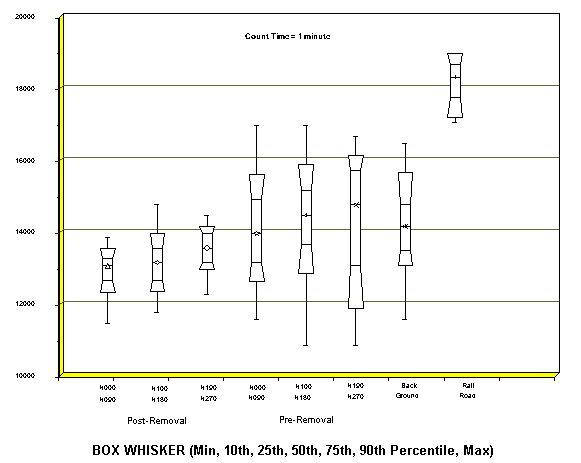
An explanation of why there was no significant difference in the direct gamma measurements between the background area and the burial ground before waste removal is more problematic. A probable explanation is that the controlling factor for the direct gamma measurements was the depth of bedrock. It was noted during trenching operations that the bedrock had a direct gamma radiation value of up to 20 uR/hr. It was also observed that a substantial area of the burial ground had a soil layer that was substantially deeper than the background area. The direct gamma radiation data was re-evaluated by dividing the burial ground into three zones from north to south with the northern-most zone being characterized as the area with the shallowest depth to bedrock and the least waste volume, a middle zone with a moderate depth to bedrock with more waste than the northern zone and the southern most zone which had the majority of waste but with bedrock generally ten feet or more below the surface. The results are shown graphically in Figure 1, a box whisker diagram. The data is expressed as the minimum, 10th, 25th, 50th, 75th, 90th percentiles and maximum values for each of the three zones both before and after the waste was removed. For comparative purposes, the background data is shown in a similar format. Figure 2 shows the same information but in the form of a high/low graph. The graph shows the data mean, the mean +/- two standard errors and the mean +/- two standard deviations.
Not shown is the area with the highest average direct gamma radiation measurements. This area was the railroad which contained ballast comprised of a granitic material. The railroad passed by a public school and athletic field and through the university campus.
Figure 1. Direct gamma radiation at one meter - affected and background areas.
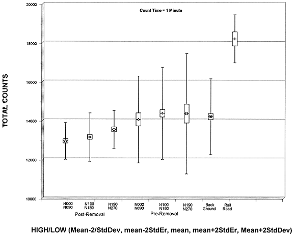
Figure 2. Direct gamma radiation at one meter - affected and background areas.
Gamma Spectroscopy Results
Cs-137 was detected in the background soil samples in 0-6 inch horizon only. The Cs-137 soil concentration ranged from below the minimum detectable level (MDL) to 0.44 pCi/g and averaged 0.24 pCi/g. These range of values are well within the accepted parameters of contamination due to weapons testing fallout and/or Chernobyl. Ra-226 was also detected in the background soil samples. For measurement purposes, the radionuclide Bi-214 was used as a surrogate for the Ra-226 measurement. This relationship can be assumed if the naturally occurring U-238 present is in equilibrium. Limited alpha spectroscopy data indicated that this was the case, consequently, the range of Ra-226 values was based on the reported Bi-214 values. The Ra-226 concentration ranged from 0.35 to 1.12 pCi/g with a mean concentration of 0.71 pCi/g. All other gamma emitting radionuclides detected were associated with naturally occurring U-238, Th-232 and K-40.
Soil samples from a variety of sample types were taken from the burial ground. As previously noted five samples were taken from areas believed not to contain buried waste which were subsequently confirmed. Four of the five samples had detectable Cs-137 in the 0-6 inch profile and one sample had detectable Cs-137 in the 6-18 inch profile. Only four of the 42 pit bottom samples had detectable concentrations of Cs-137 which ranged from 0.08 to 0.14 pCi/g, well below background values. Ra-226 was the only other man-made gamma emitting radionuclide detected in the burial ground. Sixty nine sampling locations were randomly sampled after the waste had been removed and the site backfilled. Samples were collected at a depth of four feet and analyzed for gamma emitting radionuclides. All Ra-226 values (as measured by Bi-214) were within the range of background values with the exception of one value, 1.41 pCi/g, which was 0.29 pCi/g above the background range. Only one of the 42 pit bottom samples had a Ra-226 value outside the background range. The one value, 2.63 pCi/g, was 1.51 pCi/g above the background range and was taken from a depth of approximately ten feet. The non-parametric Kruskal-Wallis Test was used to compare the median Ra-226 concentrations of the background site, the pit bottom samples and the environmental samples taken at the four foot depth increment with the result that there was no significant difference at the p=0.05 level. This result was consistent with the direct gamma measurement results.
Beta Analyses
The majority of the beta analysis was gross beta analysis with limited isotopic analysis for C-14 and H-3. Burial ground samples that had a gross beta value above the background range of 1.33 to 17.2 pCi/g were analyzed for C-14 and H-3. Only one of the 69 environmental samples (samples taken from a depth of four feet after waste removal and backfilling) had a gross beta measurement, 17.3 pCi/g, above the background range. For that sample, the C-14 analytic result was below the MDA and the H-3 value, 2.13 pCi/g, was just above the MDA. The 42 pit bottom samples had gross beta values that ranged from 2.17 to 28.90 pCi/g with only four of the 42 samples exceeding the gross beta range. These four samples, as well as an additional nine samples whose gross beta concentrations were within the background range, were analyzed for C-14 and H-3. The C-14 MDA for the above samples ranged from 0.57 to 0.76 pCi/g. Six of the thirteen samples analyzed had C-14 concentrations above the MDA and ranged from 0.80 to 6.11 pCi/g with only two samples above 2 pCi/g (6.11 and 3.67 pCi/g). The H-3 MDA for the above samples ranged from 1.81 to 2.08 pCi/g. Only two of the 13 samples had values above the MDA (3.92 and 7.21 pCi/g).
Organic and Inorganic Analyses
Acetone was detected in four pit bottom samples, methylene chloride in one pit bottom and chloroform in one pit bottom sample. Acetone concentrations in the soil ranged from 13 to 70 ug/kg. Methylene chloride and chloroform concentrations were 8 and 100 ug/kg, respectively. All were well below State action limits of 2,740, 80 and 680 ug/kg for acetone, methylene chloride and chloroform. Mercury was detected in only one pit bottom at a concentration of 0.224 mg/kg well below the State action limit of 17 mg/kg.
WASTE STREAM CHARACTERIZATION AND DISPOSITION
Approximately 11,000 cubic of waste and suspect soil were excavated and containerized. Representative samples were taken from each B25 box (approximately 100 cubic feet) and/or a combined sample from two B25s. TCLP analyses for volatile organics, semivolatile organics, herbicides, pesticides and metals were performed on all B25 box samples. TCLP metals also included copper and zinc. Total Organic Halides (TOX), reactive cyanide and reactive sulfide analyses were also performed. Radionuclide analyses included gamma spectroscopy, gross beta, C-14 and H-3.
All organic/inorganic analyses were BQL except for one B25 box which contained trace quantities of toxaphene. All inorganic analyses were BQL except for copper (one sample) and zinc (four samples). All TOX, reactive cyanides and sulfides were BQL. Cs-137 concentrations above 1 pCi/g were found in two B25s (1.71 and 7.48 pCi/g). C-14 concentrations ranged from 0.17 to 61.0 pCi/g and H-3 concentrations ranged from 0.41 to 933 pCi/g. The Ra-226 concentration of the B25 waste ranged from 1.85 to 20 pCi/g. Ra-226 concentrations for the approximately 300 cubic feet of hospital decommissioning waste ranged from 30 to 2,164 pCi/g.
Organic/inorganic analyses of the suspect soil in the roll offs included the Target Compound List (TCL) for volatile organics and total mercury. Radionuclide analyses included gamma spectroscopy, gross beta, C-14 and H-3.
All organic/inorganic analyses were BQL. C-14 concentrations ranged from 1.38 to 3.48 pCi/g. H-3 concentrations ranged from 12.7 to 449 pCi/g.
Approximately 3,000 pounds of animal carcasses and 15 gallons of needles, syringes, etc. were processed through the University's biomedical waste contractor. Approximately 150 bottles of unknown liquids, mostly one gallon amber jugs, were segregated intact and processed through University contractors to disposition. Based on field analyses most of the liquids contained xylenes and toluenes.
All of the containerized waste (approximately 11,000 cubic feet) was disposed of as non-hazardous, non-radioactive (Department of Transportation, <2,000 pCi/g) waste in a RCRA Subtitle C facility. Approvals were obtained from the receiving State from both their solid and hazardous waste division as well as their radiological division to dispose of the waste. Part of the approval process included analysis of sample splits by and independent third party laboratory selected by the State (this was above and beyond the split sampling required by the State where the waste site was located) as well as a determination that the radiological hazard was less than 5 mrem per year to the general public using conservative assumptions and the RESRAD model.
The 300 cubic feet of Ra-226 waste was shipped as Class A LSA waste to SEG for volume reduction and transshipped to Chem Nuclear's Barnwell, South Carolina, facility for disposal. The BacTec liquid waste was received and treated by Perma-Fix. Other waste streams (animal carcasses, biomedical and liquid wastes) were processed through the University contractors.
CONCLUSIONS
Based on the results from extensive characterization data, all buried waste and associated soils with low levels of contamination were successfully removed. All containerized waste was characterized, manifested and transported for treatment and/or disposal. Certifications were obtained from the waste brokers and/or receiving disposal facility/state agency that the waste met all acceptance criteria and that the waste had been received and disposed of.
Based on the final report provided by NFS to the customer they were successful in their first application to the authorized State in obtaining an unrestricted release determination for the burial ground both for the organic/inorganic chemicals and the radiological contaminants.