IDENTIFICATION AND LOCATION OF WASTE BURIAL TRENCHES
USING GEOPHYSICAL SURVEYS AND INTRUSIVE INVESTIGATIONS
AT THE WATTS FARM LOW-LEVEL RADIOACTIVE WASTE DISPOSAL SITE,
WILKES COUNTY, NORTH CAROLINA
Robert P. Cannon, P.G., Edward D. Billington, Gary D. Rogers, P.G.
Applied Geosciences and Engineering Inc.
405-A Parkway Drive
Greensboro, NC 27401
ABSTRACT
A common problem in the remediation of low-level radioactive waste (LLRW) disposal sites is the accurate delineation of disposal trench boundaries and the concern for waste being buried in unknown or unauthorized areas. These studies represent a case history of the assessment of the Watts Farm Low-Level Radioactive Waste Disposal Site in North Carolina using multiple non-intrusive geophysical surveys followed by intrusive excavations.
The Watts Farm Disposal Site was operated in 1978 and 1979 as a licensed LLRW disposal facility. The boundaries of trenches where waste was buried was not well known and claims had been made that LLRW was buried in locations other than the reported disposal area. This investigation of the Watts Farm LLRW disposal site and surrounding property was conducted in 1996 to accurately identify the location of the burial trenches and to locate potential unauthorized LLRW disposal locations. Approximately one year after the surveys were conducted, the waste was excavated for final remediation.
The investigations were conducted in two phases, first by multiple geophysical survey methods followed by intrusive excavations using a backhoe. The work was performed for the North Carolina Department of Environment, Health and Natural Resources, which had a high level of interest in discovering all LLRW disposal trenches or pits for subsequent exhumation and disposal off-site.
Waste buried at the site was reported to consist of crushed glass and scintillation vials, and vermiculite and dry laboratory wastes. All dry wastes and most crushed vials were believed to be buried in metal drums, although approximately 500 cubic feet were reported to have been dumped loose into a burial trench. The non-intrusive investigation included geophysical surveys using multiple EM, magnetometer, and ground-penetrating radar (GPR) instruments to locate areas of possible waste burial. Each geophysical method was "calibrated" over the general area of the known waste disposal trenches to determine instrument response to disturbed soil and/or buried waste. The geophysical survey data was plotted and evaluated in the field to guide exploratory excavations immediately thereafter. Geophysical anomalies that could not be explained by visible cultural effects were excavated to determine whether LLRW or other material was buried at that location. The intrusive investigation included excavation of soil and identification of the excavated materials.
The surveys effectively met the dual objectives of demonstrating that waste was not found in unauthorized areas and accurately locating the boundaries of the disposal trenches. Additionally, the surveys discovered waste in areas within the authorized burial area that were not known to exist and would not have been remediated if the surveys had not been conducted. Although the surveys discovered multiple locations of buried farm waste outside of the authorized disposal area, no LLRW was discovered associated with that waste. Using multiple geophysical techniques to identify potential waste burial areas helped to target intrusive excavations and helped identify potential disposal trenches or pits that would have been missed using only one technique.
INTRODUCTION AND ACKNOWLEDGEMENTS
In July and August 1996, Applied Geosciences and Engineering Incorporated (AG&E) conducted geophysical surveys and intrusive investigations at the Watts Farm Low-Level Radioactive Waste (LLRW) Disposal Site in Wilkes County, North Carolina. The majority of the work was performed for the North Carolina Department of Environment, Health and Natural Resources (NCDEHNR) under Contract T6005. A ground-penetrating radar survey of the known burial area was conducted under a subcontract to ERM-SE, Inc. as part of their contract with NCDEHNR to properly dispose of the waste off-site.
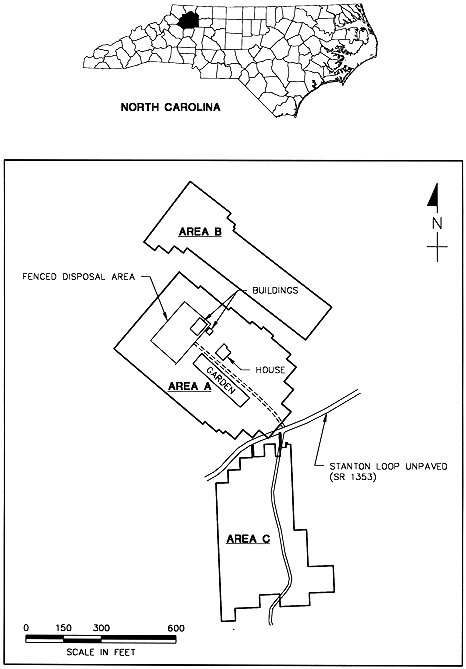
The Watts Farm site is located in Wilkes County, North Carolina, approximately ten miles west-northwest of Wilkesboro (Figure 1). The site lies on a terrace above the North Prong of Lewis Fork Creek and includes some level areas surrounded by moderate to steep slopes. Investigations were conducted in Areas A, B, and C as shown in Figure 1. The area licensed for the disposal of LLRW is located in a fenced area accessed by a gravel driveway from State Road 1353 (Stanton Loop Road).
Fig. 1. Location and Site Investigation Areas
The site operated as a LLRW disposal site for about one year beginning in July 1978. During that time, LLRW materials were buried within the fenced area. This authorized disposal area was reported to include a known burial trench or trenches with reported dimensions of approximately 25 feet wide by 12 feet deep by 60 feet long. Buried material was reported to consist of two types: 1) crushed glass and scintillation vials, and 2) vermiculite and dry laboratory wastes. All dry wastes and most crushed vials were reported to be buried in metal drums, although approximately 500 cubic feet were reported to have been dumped loose into a burial trench. Contaminants thought to be present include Carbon-14, tritium, and organic solvents.
The purpose of the investigations was to locate any unauthorized waste disposal locations at the Watts Farm low-level radioactive waste burial site and to delineate the boundaries of the known burial area. A non-intrusive geophysical investigation and intrusive investigation using a backhoe were conducted. Photographs of the site investigations are shown in Fig. 2. The intrusive investigation included excavation into suspect areas identified during the non-intrusive surveys. In addition, excavations were made in a grid pattern to provide additional assurance that buried waste had not been missed by the geophysical surveys.
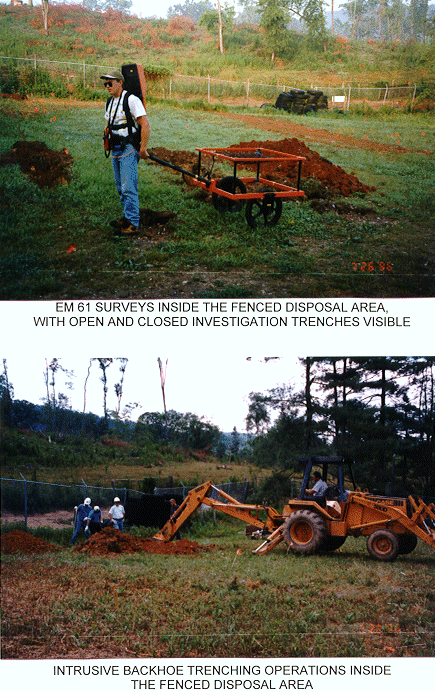
Fig. 2. Photographs of Site Investigations
Non-intrusive and intrusive surveys were conducted in three separate areas of the farm property thought to include all likely property for authorized and unauthorized burial (Areas A, B, and C on Figure 1). Area A is a little larger than six acres and includes the fenced disposal area, the farmhouse, driveway, and garden. Area B (about 3.4 acres) is located in a lower open field between Area A and the North Prong of Lewis Creek. Area C (about 4.8 acres) is located along a farm road in a field across State Route 1353 from Area A.
NON-INTRUSIVE GEOPHYSICAL INVESTIGATIONS
Geophysical surveys were conducted using magnetometer and electromagnetic (EM) methods. Surveys of the fenced disposal area in Area A included ground penetrating radar profiling. The results of the geophysical surveys were used to guide the intrusive investigations.
The geophysical instruments included a Geonics EM-61 metal detector, a Geonics EM-31 terrain conductivity meter, and a Geometrics G858 magnetometer. Ground-penetrating radar surveys were also conducted in the vicinity of the known disposal area using a GSSI SIR-2 with 100 and 300 megahertz antennas to delineate the boundary of the known burial area and determine the location of the individual burial trenches. All anomalies identified by geophysical techniques that could not be caused by known cultural effects were excavated to demonstrate whether LLRW had been buried at these locations. The non-intrusive surveys identified about 50 geophysical anomalies that required further investigation. A total of 2548 linear feet of trenches, 95 pits, and 3 hand dug excavations were made to investigate the geophysical anomalies and other suspect areas. Maps showing the result of the investigations were prepared to identify areas to be excavated for future waste exhumation and disposal. In addition to identifying the outlines of the known disposal trenches and the depth to the top of waste drums, the surveys found waste buried in locations where waste disposal had not been reported, but still within the authorized disposal area. No LLRW was discovered outside of the authorized disposal area. The additional LLRW discovered in the fenced area included plastic and glass scintillation vials, both crushed and intact, and two partially crushed steel drums containing waste.
Non-Intrusive Geophysical Investigations In The Fenced Disposal Area
Of the three EM/magnetometer methods, the EM-61 data proved the most useful for identifying anomalies within the fenced area. Although some of the same anomalies were observed in the EM-31 and the magnetometer data, these instrument readings were much more heavily affected by cultural effects than the EM-61 readings. The cultural features that dominated the EM-31 and magnetometer readings included the metal fence, buried and overhead utilities, underground storage tanks, and a metal building.
The EM-61 contoured data plot for the fenced area shows distinct anomalies in several locations (Figure 3). Anomalies that could not be explained by visible cultural effects were marked for trenching during the intrusive investigation.
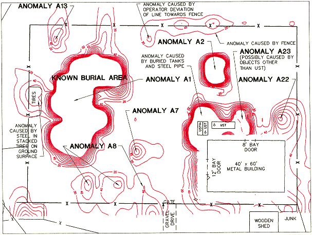
Fig. 3. EM-61 Anomalies in the Fenced Disposal Area
The purpose of the GPR survey was to provide images of the disturbed/undisturbed soil interface and of the buried metal drums. Two GPR antennas were used for this work: a 100 megahertz (MHZ) antenna for deeper penetration and a 300 MHZ antenna for higher resolution. However, it was recognized that the clayey soil at the site would probably absorb some of the radar energy, thus reducing the strength of the reflected signal and the overall effectiveness of the GPR survey.
The GPR data were converted to depth using the time-depth relationship established during a calibration test over a known buried pipe. Signal penetration in the undisturbed areas was found to be extremely limited; no verifiable signals were obtained below the surface reflection. The lack of penetration is attributable to the highly conductive clayey site soils that absorb most of the GPR signal. Signal penetration in the disturbed areas was limited to about 3 feet for the 300 MHZ data and about 5 feet for the 100 MHZ data. The increased signal penetration in the disturbed areas is attributed to the lower conductivity of the less dense, drier backfill material.
The interpretation began with identification of the edge of the excavation from the higher frequency 300 MHZ data. The edge of the excavation was easily identifiable in many locations from the unprocessed data.
The approximate depth and location of the top of drums were mapped from the lower frequency 100 MHZ data. The results of the data interpretation of the processed 100 MHZ data are shown in Figure 4. The approximate depth of fill was also mapped from the 100 MHZ data. The GPR data interpretation was integrated with the results of the intrusive investigation to show the approximate minimum depth of disturbed fill across the site.
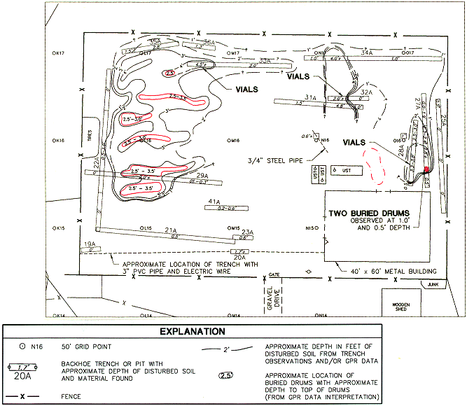
Fig. 4. Disturbed Soil and Location of LLRW in the Fenced Disposal Area
INTRUSIVE INVESTIGATIONS
The intrusive investigation included backhoe excavations and a few hand dug excavations. Trenches were excavated at anomalies identified during the geophysical survey, at mounds or surface depressions, areas with surface or partially buried debris, and at locations in and near the fenced disposal area that were identified as possible areas of waste burial. In addition, about 100 test pits were excavated on 50 foot grid centers in Area A. Each excavation was examined by a N.C. licensed geologist for signs of disturbed soil and foreign material and each soil layer was described, measured, and determined to be disturbed or undisturbed. Additional trenches were excavated to determine the outer boundary of buried waste within the fenced area. A total of 2,548 linear feet of trenches was excavated.
The backhoe excavations and hand dug excavations in Areas A, B, and C were evaluated for the presence of disturbed soil and LLRW. No LLRW was found in any of the investigation areas except within the fenced disposal area in Area A. Many of the geophysical anomalies in Areas A, B, and C were found to be caused by buried farm and household-related debris.
Fenced Disposal Area
The results of the trenching investigation and the geophysical anomalies that were investigated are shown on Figure 4. LLRW was encountered at three locations within the fenced area: 1) scintillation vials were found on the northwestern side of the fenced area in the known disposal area (Trench 33A); 2) scintillation vials were found to the north of the metal building (Trench 32A); and 3) scintillation vials (Trench 28A) and two barrels (Trench 27A) were found on the northeast side of the metal building. Fill soil and non-LLRW material were encountered in several trenches. Excavations were not made into the known disposal trenches as part of this work. However, shallow backhoe trenches were excavated to determine the boundaries of the known disposal area.
Area A, B, and C, Excluding Fenced Disposal Area
No LLRW was encountered in any of the trenches outside of the fenced disposal area. Farm-related material was encountered in several trenches excavated at geophysical anomalies. This material included metal debris such as horseshoes, pipes, and roofing material, and non-metallic debris such as lumber, terra cotta pipe, and pieces of bathroom fixtures. Household waste such as tin cans and bottles was present on the ground surface on the hillslope in the wooded area to the east of the house and fenced area. Some geophysical anomalies were apparently caused by a drain system composed of terra cotta pipe and lumber. A geophysical anomaly in Area B was apparently caused by a water-bearing gravel lense.
CONCLUSIONS
The non-intrusive and intrusive investigations at the Watts Farm site found that 1) the geophysical surveys were sufficient to locate typical buried debris and LLRW contained in metal drums or buried with some metal debris; 2) geologists knowledgeable in the site soil profiles were able to determine whether or not the soil in each excavation had been disturbed; and 3) material related to disposal of LLRW was not found outside of the fenced disposal area.
The approximate extent of disturbed soil, the approximate location of buried drums, and the observed location of LLRW exposed in excavations have been mapped from the non-intrusive and intrusive data. In addition to the known disposal area, the intrusive investigation identified three additional locations within the fenced area that contained LLRW. This integrated data interpretation provided information that was used to guide the excavation of the fenced disposal area. Subsequent excavation of the waste in 1997 demonstrated that the surveys accurately delineated the boundaries of waste burial trenches and pits.