EFFICIENT GROUND-BASED GAMMA RADIATION SURVEYS
OF LARGE AREAS
D. Huffmana, C.H. Clement
Low-Level Radioactive Waste Management Office, Atomic Energy of Canada Limited
1595 Telesat Court, Suite 700
Gloucester, Ontario, CANADA, K1B 5R3
ABSTRACT
The Low-Level Radioactive Waste Management Office (LLRWMO) has developed an automated system of data collection, recording and analysis for performing gamma radiation surveys of large areas in a cost-effective manner. The system integrates the collection of gamma radiation data with corresponding coordinate information and records the information automatically in electronic format. The survey system has been adapted to meet a variety of different project requirements but the basis for its uses remains consistent throughout: the survey system enables a great deal of data to be acquired in an efficient, reliable and reproducible manner. Because of the increased efficiency over more traditional methods of manually reading and recording gamma radiation and coordinate data, approximately 100 times as many data points can be collected per person hour of field time. This overall increase in surveying efficiency has been translated into both a decrease in survey costs and an increase in detection power. This paper focuses on the approach of the LLRWMO towards large-area surface gamma radiation surveying.
INTRODUCTION
The LLRWMO is operated by Atomic Energy of Canada Limited (AECL) through a cost recovery agreement with Natural Resources Canada, the federal department which provides the funding and establishes national policy for LLRW management. Part of the mandate of the LLRWMO is to resolve historic radioactive waste problems that are a federal responsibility1. Historic wastes are LLRW for which the original owner can no longer be held responsible and which are managed in a manner no longer considered acceptable. If they are wastes for which the federal government accepts responsibility, their management comes within the mandate of the LLRWMO.
In order to fulfil this mandate, the LLRWMO is routinely required to characterize areas of land which may have been contaminated by uranium or radium waste. Property areas for LLRWMO surveys have ranged from residential properties to several square kilometre parcels of land. These characterizations can serve several purposes including screening level assessments, contamination detection and delineation, cleanup guidance, and verification that criteria have been met following cleanup. Typically, survey areas are sizeable enough to warrant a significant effort in the planning and logistics of the survey program. Traditional methods of performing gamma radiation surveys of large areas, described briefly below, generally involve a considerable amount of resources for the desired technical product. As these methods are labour intensive, survey programs have been designed around available time and money rather than on technical goals resulting in a program that has little statistical power. Reducing the effort required to conduct a gamma radiation survey while increasing the quantity and quality of the data collected makes for much more efficient program that can realize technically based goals.
This paper discusses a computer-assisted gamma radiation survey system developed by the LLRWMO that has:
The LLRWMO has continually adapted the computer-assisted survey system to meet the various survey requirements encountered by the LLRWMO. A paper discussing the many system variants appears in this conference as a companion to this paper3.
TRADITIONAL METHODS
Traditionally, gamma radiation surveys have been conducted by field personnel using hand-held analog scintillometers. Gamma radiation readings were taken at evenly spaced points on the property, often on a 3x3 metre or larger grid. The area between the grid points was generally scanned by the surveyors, and any anomalous readings detected during the scan recorded. All data collected were recorded manually on paper, and analysis of these paper records was used to determine the results of the survey.
This "manual" method of conducting surface gamma radiation surveys has several limitations. This method is very labour intensive, the scanning operation is quite subjective, can vary from surveyor to surveyor, and large quantities of data (particularly for larger surveys) must be managed by hand. Often the level of survey detail is determined by time available rather than desired survey coverage. More desirable would be a system that increases objectivity in data collection and analysis, minimizes manual data handling, and is more amenable to quality assurance procedures. These goals have been accomplished by introducing computer technology.
COMPUTER ASSISTED SURVEYS
A computer assisted gamma radiation data collection and analysis system was developed by the LLRWMO2. The system uses off-the-shelf gamma radiation detection instruments so that they can be easily replaced and repaired. Most system variants also incorporate a global positioning system (GPS) receiver. Use of the GPS has nearly eliminated time spent on several site setup requirements such as establishing a reference coordinate system and laying out grid point markers. The instruments are controlled by a portable computer running custom software developed specifically for this purpose. The software records all data from the radiation detection instruments and the GPS, pairing gamma radiation measurements with global coordinates. All data is stored electronically, amendable to most spreadsheet, mapping or computer assisted design programs. Custom analysis programs have also been developed so that interpretation and reporting is reproducible and traceable.
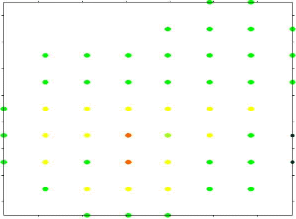
The three figures below show gamma radiation surveys of approximately 1 hectare of land. The first two figures show gamma radiation survey data on a 20 m and 10 m grid spacing, collected in the traditional manner. The third figure shows the output of a computer assisted survey of the same area. The surveys depicted in Figures 1 and 3 required similar amount of time to produce. The survey performed to produce Figure 3 identified an area contaminated with radium residues. Figure 1 does not identify the contaminated material. Figure 2 identifies the material but does little to delineate it.
Fig. 1. Survey Conducted on 20 m Grid Spacing 52 Data Points
Estimated Field and Reporting Time: 3 Hours
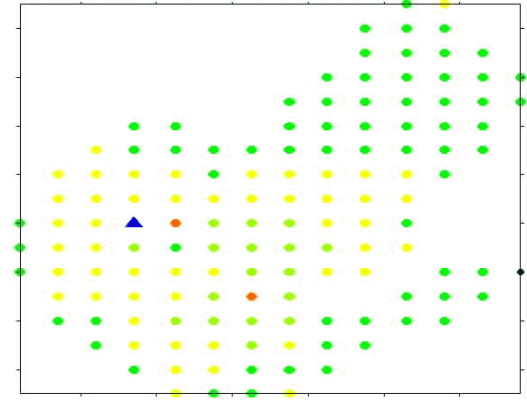
Fig. 2. Survey Conducted on 10 m Grid Spacing: 136 Data Points
Estimated Field and Reporting Time: 8 Hours
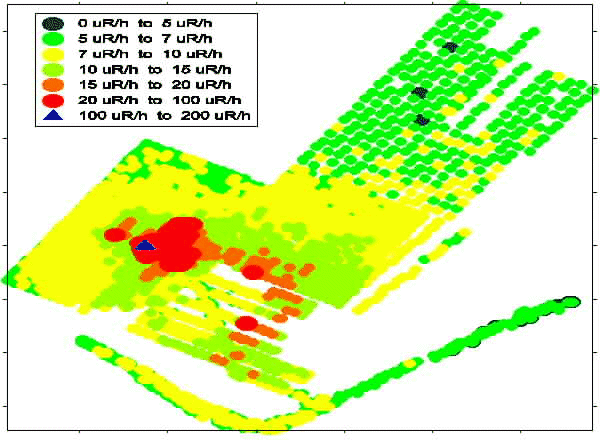
Fig. 3. Computer-Assisted Survey: 5043 Data Points
Estimated Field and Reporting time: 3 Hours
Several years of prototyping lead to the development of a system consisting of two electronic radiation meters each using a 2x2" NaI scintillation detector. To provide portability in the field, these components are then mounted on a frame (initially a golf cart, which has lead to the system becoming known as the "cart"). Over the last few years, the computer assisted data collection system has been developed into a number of variants in response to specific project requirements. A backpack based variant was developed for very difficult terrain. For larger areas, tractors and all-terrain vehicles have been used operating as many as six radiation detection instruments simultaneously. A road-based survey system centred around large volume plastic scintillators mounted in a van has also been developed. The integration of gamma radiation measurements with coordinate information has changed significantly with the advent of the Global Positioning System (GPS). Several variants using different GPS hardware have been developed for coordinate precision requirements ranging from 100 m to less than 1 m. More details on the various data collection system variants can be found in a companion paper3 by the same authors.
AN INTEGRATED APPROACH
The current LLRWMO approach to large area surface gamma radiation surveys integrates several data collection methods. Where possible, the computer assisted data collection variants are used because they are much more efficient in terms of the amount of data collected for a given amount of field time. The specific variants chosen depend on several factors including: required detection thresholds; data density requirements; and, the nature of the terrain to be covered. In areas where the computer assisted systems are still not practical, some data are collected using hand held instruments which log data points. Occasionally, the more traditional method of reading analog values and recording gamma measurements and locations in a log book is used.
Often areas of a site may require different levels of survey coverage or terrains may differ significantly. In these cases several system variants may be used on the site. Once the data have been collected they are integrated for the purposes of data management and analysis, and the reporting of results. Some of the analysis methods have been fine-tuned to specific data "types" (such as very dense data collection required for identification of point sources and data collected on a coarse grid spacing which requires interpolation), although the overall approach is the same. The most sensitive methods are completely automated, and therefore objective and repeatable, and the methods themselves are very amenable to the application of quality assurance processes. Subjective analysis by experts is also employed where the required interpretation reaches beyond what is possible using automated routine.
The general approaches to data collection and analysis fall into several broad categories based on the type of area surveyed and/or the characterization requirements although the primary consideration is the amount of detail required during the survey. It has been the experience of the LLRWMO that the level of detail varies with the size of the property and the difficulty of the terrain. The most detailed surveys could be carried out over large areas and difficult terrain, but the costs may be prohibitive. On the other hand, for small areas the costs associated with a very detailed survey are often not considerably more than for a screening level survey.
When performing an investigative survey of an area, a number of factors must be considered during the planning phase to determine the level of survey detail required to meet the survey objective. An estimate of the required survey grid spacing can be made with an understanding of the ability of the survey instruments to measure radioactivity, and an estimate of the size and specific activity of the contaminated area to be identified. The probability of detection is based on the detectable area and the grid density for the survey. The detectable area is based on: the ability of the measurement instrument to discern elevated gamma radiation readings from normal background radiation; the areal extent of the contamination; and, the source strength of the contamination observable at the surface.
Determining the detectable area of the contamination under investigation requires some knowledge of the nature of the contamination. If the contamination is due to the spread of discrete, isolated contaminated artifacts then the contaminated area requiring identification will be relatively small while contamination due to indiscriminant dumping of truckloads of material will be much larger. As outcome of this determination, statements must be made regarding the goal of the survey effort and assumptions made in the determination. An example of these outcome statements are as follows.
Small Properties and/or Discrete Anomaly Detection Survey
For small areas or areas requiring very high data density (greater than one reading per square metre) the approach generally taken by the LLRWMO is to mount the automated detection system on a hand-pushed cart. Coordinate information is determined using a system of dead reckoning. The high precision required for these surveys is difficult to obtain using global positioning systems, particularly when large sections of the sky are obscured by buildings around which the survey must take place.
For small residential properties it has been found that data can be collected with the automated survey system with a data density of 2 readings per square metre in the same amount of field time as would be required to perform a 3 m x 3 m gridded survey in the more traditional manner. Data densities of 4 readings per square metre have been used by the LLRWMO for finding discrete, low activity particles.
In 1980, evidence of radioactive contamination was found in a residential area of Scarborough, Ontario, known as Malvern. The material existed as discrete particles, typically less than 5 cm in length, contaminated with 226Ra. Redistribution of the soils during construction of the residential development resulted in the spreading of discrete particles over approximately 14 hectares of property leaving isolated radioactive artifacts in a large volume of otherwise uncontaminated soil. Cleanup criteria established for the project were such that where cleanup was undertaken residual concentrations of 226Ra were not to exceed 0.074 Bq/g and all discrete 226Ra contaminated artifacts exceeding 0.148 MBq were to be identified and removed. Several survey campaigns were carried out to identify and better delineate the affected areas. In 1993, forty two urban residential properties were identified requiring remediation. In 1994, a survey of 450 properties was carried out by the LLRWMO using the computer-assisted radiation survey technology. Data were collected on each property on a 0.5 m grid spacing. Statistical tools were developed during this program to identify the presence of contamination. Since individual gamma readings were typically within the range of normal background, contamination recognition algorithms relied on the very dense data grid to identify potentially contaminated areas based on local variability in gamma radiation readings. This survey program identified 25 additional properties requiring cleanup and removed discrete radium contaminated artifacts from more than 50 other properties. The LLRWMO conducted a cleanup of the Scarborough, Ontario neighbourhood in 1995.
Large Open Areas and/or Delineation Survey
In order to delineate contamination over large open areas, the most efficient approach has been to mount the computer assisted data collection system with a GPS receiver on a tractor or all-terrain vehicle. Data densities on the order of one-half to one reading per square meter can be achieved while maintaining survey rates of up to 80 000 square meters (8 hectares) per day.
In 1997, the LLRWMO participated in some site characterization of the well and irrigation fields at an uranium leach mine. Uranium leach mining is a process by which carbonated water is pumped down to a uranium deposit, the uranium dissolves, the solution is pumped out of the ground and the uranium precipitated from the solution. Typically the waste water is either pumped back down a well or used to irrigate fields. Gamma radiation data was collected on a 5 m grid spacing at a rate of over 10 hectares per survey day. A differential GPS unit was used to collect coordinate data with approximate 1 metre accuracy. With these data, areas requiring cleanup could be identified in each of the fields of interest.
Use of Several System Variants
The LLRWMO conducted an investigative gamma radiation survey of a 100 hectare farm in southern Ontario. A portion of the property housed a crude radium recovery laboratory in the 1940s and contamination may have been spread by farming and land grading activities.
Of the 100 hectares, approximately 70 hectares had limited access due to rough terrain and dense brush and has mature trees that predate the contamination; the null hypothesis for this area was that there was no contamination in the area. For this area, survey lines were spaced 100 m apart and readings taken integrating over 10 m increments with a hand-held instrument with data logging capabilities. Similarly, at each 10 m interval, location data was logged using a GPS. At the completion of a survey line, gamma radiation data and position data were downloaded from each instrument to a portable computer and then matched.
Approximately 30 hectares of the property were cleared and cultivated including the location of the old laboratory that was the originator of the waste; the null hypothesis for this area was that contamination was present. For the potentially contaminated area, the intent of the survey was to find as little as 1 dump truck load of contamination, should it exist. This area was surveyed by mounting the automated system onto an all-terrain vehicle. Coordinate information was recorded using a differential GPS unit with approximately 1 m position accuracy. The survey conducted by the LLRWMO successfully identified four distinct contaminated areas. Using traditional survey techniques, a survey taking approximately four times the number of person-hours to complete, with readings on a 20 m grid spacing, would have a very low probability of identifying any of these contaminated areas.
Where evidence of contamination was found with the all-terrain vehicle survey, a detailed cart survey collecting 2 readings per metre square was conducted to better delineate the contaminated area.
Survey over Difficult Terrain
In some cases, the terrain to be covered is impassable by any method other than on foot. Under these circumstances, two approaches have been used. The automated system can be mounted in a backpack and parallel lines can then be walked while collecting data. The other approach frequently collects individual readings with hand-held instrumentation and records the information in a logbook. In both cases, simple hand-held GPS receivers have been used to determine location from time to time, interpolating between determinations. More sophisticated use of GPS data is often impossible due to tree cover obscuring the sky over much of the survey area.
SUMMARY AND CONCLUSIONS
The many variants of the computer assisted gamma radiation data collection system now play a significant role in the collection of field data on LLRWMO projects. Automated methods are preferred, where they can be applied, due to the greatly increased efficiency of data collection, as well as the added benefits of increased objectivity in data collection and efficiency of analysis of electronic data.
The success of the computer assisted gamma radiation data collection system variants ensure their continued used in LLRWMO projects. The development of additional variants is expected to continue as new projects with unique requirements arise. Traditional methods which make use of gridded gamma radiation surveys have not been completely replaced, but they now form only a small part of an integrated approach to more efficient site characterization. The advantages of having the data collected in this manner are many. The survey system:
REFERENCES
FOOTNOTES
a) Author to whom correspondence should be addressed. Mr. Huffman can be reached at the address given above, by phone at (905) 885-9488, fax at (905) 885-7458, or e-mail at huffmand@aecl.ca.