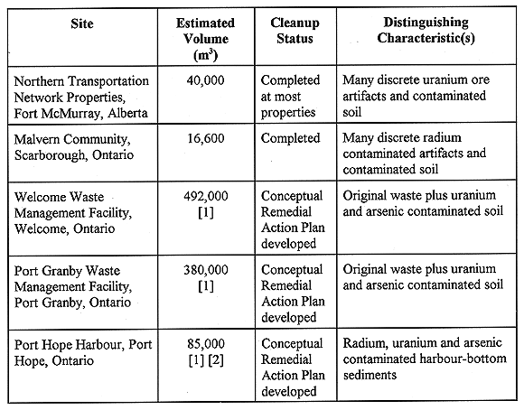
Table I Overview of Sites Selected for this Study
C. H. Clement, D. M. Huffman
Low-Level Radioactive Waste
Management Office
Atomic Energy of Canada Limited
1595 Telesat Court,
Suite 700
Gloucester, Ontario, Canada
K1B 5R3
ABSTRACT
This paper examines the volumetric inventory distribution of contaminated materials at various historic low-level radioactive waste (LLRW) sites in Canada. This distribution shows what fraction of the contaminant inventory is in what fraction of the waste volume irrespective of cleanup or segregation criteria. As well, the volumes of material at the sites are examined with respect to selected criteria.
Five historic radioactive waste sites in Canada are examined in detail. In each case, a large fraction of the contaminant inventory is found in a relatively small fraction of the volume. As well, only a small fraction of the material, ranging from approximately 25% to less than 1% at the various sites, exceeds regulatory limits which would require a licence (for radioactive contaminants) or disposal as hazardous waste (for chemical contaminants).
Segregation of excavated material based on future disposal criteria may lead to significantly reduced interim storage and final disposal costs since each fraction of the waste can be treated in a manner appropriate to its potential hazard. The more expensive treatments can be reserved for a relatively small volume of the most contaminated material, while less expensive methods can be applied to the remainder.
INTRODUCTION
This paper examines the volumetric inventory distribution of contaminated materials at various historic low-level radioactive waste (LLRW) sites in Canada. This distribution shows what fraction of the contaminant inventory is in what fraction of the waste volume irrespective of cleanup or segregation criteria. As well, the volumes of material from the sites are examined with respect to selected criteria. The contamination at these sites dates back to the time of the radium industry and the early years of the uranium industry. At many sites, the original waste volume has been substantially increased due to contamination of soil by natural contaminant transport processes or by physical mixing from activities such as property development. This results in a heterogenous distribution of the contaminants between the original wastes and the native soils contaminated by the wastes. In addition, contaminant distributions were often heterogenous within the wastes themselves. The expectation is that segregation of a large fraction of the contaminant inventory, but in a small fraction of the volume, may lead to significantly reduced interim storage and final disposal costs since each fraction of the waste can be treated in a manner appropriate to its potential hazard. The more expensive treatments can be reserved for a small volume of the most contaminated material, while less expensive methods can be applied to the remainder. The analyses presented in this paper demonstrate that this expectation is true.
SITES SELECTED FOR STUDY
Five sites have been selected for use in this study. An overview of these sites is presented in Table I. The five sites include two examples which contain a fraction of the contaminant inventory in the form of small, discrete pieces of contaminated material (Fort McMurray and Malvern), two which make up a significant volume of the historic LLRW in Canada (Welcome and Port Granby), and one example of contaminated sediments rather than soils (Port Hope Harbour).
Table I Overview of Sites Selected for this Study
Former Northern Transportation Network Sites at Fort McMurray, Alberta
Fort McMurray, Alberta was the final transfer point in the Northern Transportation Company Limited (NTCL) network used by Eldorado Gold Mines to transport uranium ore and concentrate from their Port Radium mine in the Northwest Territories. A 1,400 mile water transportation network was used to carry uranium ore and ore concentrates from the mine site on Great Bear Lake to the barge-to-rail transfer point in Fort McMurray, Alberta. From Fort McMurray, the ore was transported by railcar to its final destination in Port Hope, Ontario for refining. From the 1930s to the 1960s, the NTCL property was used as part of a barge-to-rail transfer point in Fort McMurray.
In the summer of 1992, during investigations of transfer points along the water route, elevated levels of radioactivity were discovered at old industrial properties in the Lower Town site of Fort McMurray. Incidental spillage and tracking during unloading of barges and loading of railcars is the likely cause of the contamination. The uranium contamination is considered an historic waste and falls under the mandate of the Low Level Radioactive Waste Management Office (LLRWMO).
The barge-to-rail transfer areas at Fort McMurray have subsequently been divided into a number of separate properties. Clean-up activities proceeded on each property individually. Since the autumn of 1992 approximately 22 hectares of Fort McMurray property has been released for unrestricted use with 5.3 hectares undergoing clean-up activities under the Fort McMurray Historic Uranium Cleanup Project. The final 5 hectares of property is scheduled to be cleaned up in the near future.
Conventional earth moving technologies were employed in the removal of the wastes from the sites. Radiation surveyors delineated areas of contamination and segregation of materials was performed on site. A small volume of licensable material (approximately 84 m3, and referred to as Category A material) was excavated and removed to storage at the LLRWMO interim storage facility at Chalk River Laboratories of Atomic Energy of Canada Limited (AECL), at Deep River, Ontario. This facility is licensed by the Atomic Energy Control Board (AECB), the nuclear regulatory agency in Canada. Approximately 26 500 m3 of mildly contaminated soil (referred to as category B material and classed as industrial waste) was taken to a disposal cell constructed at the Fort McMurray landfill site. Soil which did not exceed cleanup criteria was left in place as it poses no significant health risk for future uses of the site. An estimated 8000 m3 of mildly contaminated material and 400 m3 of licensable soil remain to be excavated.
The material found at the Northern Transportation Network sites was chosen as an example of an historic LLRW site with a significant fraction of its contaminant inventory in the form of small, discrete pieces, referred to as artifacts in this paper.
Malvern Community, Scarborough, Ontario
Radium contaminated soil was discovered at McClure Crescent in the Scarborough community of Malvern in 1980. Several initiatives to remove it failed when residents who lived close to the proposed interim storage sites objected vigorously. The Malvern Remedial Project (MRP), a joint Canada/Ontario project to complete the cleanup in the Malvern area, was announced in 1992 March. The main elements of the project were to complete the cleanup of soils at McClure Crescent and at a second location subsequently discovered at McLevin Avenue, to sort the soil to remove all licensable material and to store the remaining mildly contaminated soil at the sorting site until a permanent disposal site is available in Ontario. An extended survey of the Malvern community was conducted to confirm that no further areas of similar contamination exist. The largest volume of contaminated material at Malvern is soil with radium-226 concentrations less than ten times the background specific activity. A relatively small portion of the material, approximately 0.3% by volume, was found to have up to approximately one hundred times the background specific activity. However, the majority of the AECB licensable activity was found in the form of short lengths (0.5 to 15 cm) of radium impregnated plastic tubing.
In order to minimize waste volumes, soil-sorting equipment was acquired, assembled and tested. The approach of using an automated soil sorting conveyor system to remove material with licensable amounts of radium, and then to characterize and segregate the soil into clean and mildly contaminated inventories, was customized for application to the MRP. The original version of the system was developed for a partial cleanup at McLevin Avenue in 1990.
A total of approximately 16,600 m3 of soil was excavated as part of the MRP during the summer of 1996. Only about 50 m3 was classified as licensable, approximately half was verified to be clean with a confidence level of 95%, and the remainder was considered mildly contaminated. The actual volume of clean soil was higher, but the level of confidence required to classify material as clean was such that some of this soil was conservatively classified as mildly contaminated.
The material found at the Malvern site was chosen as an example of an historic LLRW site with a significant fraction of its inventory in the form of discrete radioactive artifacts. It also represents the first major application of the soil sorting conveyor system by the LLRWMO.
Welcome Waste Management Facility, Welcome, Ontario
and
Port
Granby Waste Management Facility, Port Granby, Ontario
The Welcome and Port Granby Waste Management Facilities (WMFs) were used as disposal sites for low-level radioactive wastes produced by the former Eldorado Nuclear Limited between 1932 and 1988.
The material at the Welcome WMF represents the largest volume (approximately 492,000 m3) of historic low-level radioactive waste and contaminated soils at a single site in Canada. About one third of this material has been estimated to contain (on average) approximately 40 Bq/g radium-226, 4000ppm arsenic, and 500 ppm uranium. The other two thirds has been estimated to contain approximately 0.1 to 0.4Bq/g radium-226, 50 to 100 ppm arsenic, and 10 to 20ppm uranium (1).
The contaminated material at the Welcome WMF contains an estimated 7,700 m3 of primary waste in the form of chemical residues and sludges produced at the radium refinery, and other contaminated materials from that era. The remainder of the volume is mostly made up of soil subsequently contaminated due to the presence of the primary waste.
The Port Granby WMF is second only to the Welcome WMF in terms of volume of historic low-level radioactive waste found at a single site in Canada. Of the 380,000 m3 of material, about four fifths has been estimated to contain (on average) approximately 50Bq/g radium-226, 4000 ppm arsenic, and 1000 ppm uranium. The other fifth has been estimated to contain approximately 0.1 to 0.2 Bq/g radium-226, 20 to 30 ppm arsenic, and 20 to 50 ppm uranium (1).
Approximately 94,000 m3 of this material is primary waste including large amounts of neutralized raffinate and calcium fluoride, and smaller amounts of radium waste and magnesium fluoride slag. The remainder is made up mostly of soils contaminated due to the presence of this primary waste.
The material at the Welcome and Port Granby WMFs represent a significant fraction of the historic low-level radioactive waste in Canada. It was therefore important to include both of these sites in this study.
Port Hope Harbour, Port Hope, Ontario
The Port Hope Harbour contains contaminated sediments as a result of effluent from the Eldorado radium refinery during the 1930's and 1940's. Along with uranium series radionuclides, a number of heavy metals including arsenic, cobalt, lead and nickel were found to be closely associated with the waste.
This site was selected because it represents a significant portion of the historic low-level radioactive waste in the Town of Port Hope, Ontario, and is an example of contaminated sediments rather than soil.
DETERMINATION OF CONTAMINANT INVENTORIES AND VOLUMES
With respect to inventory and volume determinations, the selected sites fall into two categories: those where cleanups have already occurred, and those where cleanup is yet to be done. Cleanup has already taken place at the Fort McMurray and Malvern sites, and is planned at the Welcome and Port Granby sites, and at the Port Hope Harbour.
The general approach to inventory and volume determination differs between those sites which have and have not undergone cleanup, primarily due to the quality and quantity of the available data. The only data available for the sites which have not undergone cleanup are limited amounts of in-situ site characterization results and results from analyses of soil samples. For sites on which cleanup work has already been undertaken, more detailed data taken during excavation, hauling, segregation, and engineered storage are generally available.
Fort McMurray
Excavated Category B soils were loaded into dump trucks for haulage to the disposal cell at the landfill site. Before each truck left the excavation site a series of gamma radiation measurements were taken with a scintillometer at locations on the top and sides of the load. The average gamma reading on the truck, after corrections for geometry and attenuation, were used to estimate Ra-226 content. Similarly, Category A materials were packaged in drums for shipment to storage. A series of measurements were taken with a scintillometer at locations on each drum and the average gamma reading, after corrections for geometry and attenuation, was used to estimate Ra-226 inventory.
Malvern
During the Malvern Remedial Project (MRP), most excavated material was characterized during the soil sorting operation. The results used in this study are the radium-226 analysis of soil samples representing each 7 m3 batch. Mildly contaminated material which did not pass through the soil sorting system was characterized using similar soil samples collected during placement of the material into an engineered temporary storage mound. A small volume of more active material was placed directly into luggers after excavation and was never processed using the soil sorting system. This material was characterized using a series of scintillometer readings taken on the outside surface of the luggers. Finally, a very small volume of radium-226 contaminated artifacts was also characterized using readings taken on the outside of the drum in which they were stored and shipped.
Welcome and Port Granby WMFs
The data used to develop the Welcome and Port Granby WMF contaminant inventories is a result of a borehole sampling program conducted to develop volume estimates by the Siting Task Force (1). This program consisted of drilling and sampling 21 boreholes at the Welcome WMF, and 15 at the Port Granby WMF. Each sample was analyzed for uranium and radium-226 by HPGE gamma spectroscopy, and by neutron activation and inductively coupled plasma analysis for a large number of chemical contaminants.
At the Port Granby WMF in particular, the inventory and volume estimates are fairly uncertain due to the limited number of boreholes and the heterogeneity of the waste. The results derived for this study do agree fairly well with previously published results (1), although this is not surprising as both are based on the same data set. A much clearer understanding of the inventory and volume of the waste and contaminated soils would be possible if additional boreholes were used to delineate the physical extent of the material. Therefore the estimates presented here are subject to significant change if additional data becomes available.
Port Hope Harbour
The data used in the Port Hope Harbour analysis was taken from the LLRWMO report "Contaminant Inventory and Average Concentrations for Contaminated Sediments in Port Hope Harbour" (3). These data are the result of a borehole sampling program carried out in 1986 for the LLRWMO. The field work was part of investigations on radiological contamination in the Port Hope Harbour and a number of on-land sites, in support of a LLRWMO program to develop plans for the cleanup and transport to disposal sites of historic waste in Port Hope.
The first phase of the two phase harbour survey program consisted of putting down thirteen boreholes within the turning basin and approach channel. During the second phase, three more boreholes were put down to more closely examine the sediment around the perimeter of the harbour. Data on total gamma radiation count rate and water content were gathered down all sixteen holes, and several samples were analyzed for concentrations of radium, uranium and arsenic. Nine composite samples were radiologically and chemically analyzed by Saskatchewan Research Council, and three additional composites were analyzed by Chalk River Laboratories for the LLRWMO.
A relationship between total gamma radiation count rate (primarily from bismuth-214, a uranium series radionuclide) and several of the contaminants was derived. Contaminant inventories were developed using total count data and the relationship between total count and contaminant concentration.
VOLUMETRIC INVENTORY DISTRIBUTIONS
In order to compare volumetric inventories between sites with varying volumes, inventories and contaminants, all results presented here have been normalized with respect to both volume and inventory.
Incremental vs. Excavated Distributions
Two ways of describing contaminant inventories were considered: net inventory and gross inventory. The net inventory is the amount of contaminant present in excess of the mean background concentration. The gross inventory is the total amount of contaminant present, including background amounts. Since the contaminants under consideration here (radium-226, uranium, thorium and arsenic) are naturally occurring, and the contaminant concentrations in significant fractions of the total volume are often of the same order of magnitude as the mean background concentrations, the difference between net and gross inventories can be significant.
The volume of material was also considered from two different viewpoints: contaminated volume and excavated volume. The contaminated volume is the amount of material which has contaminant concentrations in excess of the upper end of the natural background range. The excavated volume is the total amount of material removed from the contaminated site, and includes suspected contaminated material which was later determined to be clean, as well as clean overburden and pockets of clean soil interspersed with contaminated soils.
These two inventory types and volume types have been used to generate two types of volumetric inventory distributions. The "incremental" distribution makes use of the net inventory and the contaminated volume. This allows the distribution of the contaminant within the contaminated material to be seen without the confounding influence of clean overburden. The "excavated" distribution makes use of the gross inventory and excavated volume. Net inventory would not have been appropriate for the excavated distribution since a fraction of the volume is clean material, much of which would have a negative net inventory.
For the purposes of this study, the incremental distribution was chosen as more appropriate than the excavated distribution for several reasons. For three of the five sites excavation has not yet taken place, although it would have been possible to estimate excavated volumes from the characterization data. More importantly, the incremental distribution provides a clearer indication of the distribution of the contaminant in the contaminated volume.
Sites with Multiple Contaminants
In many cases, a site is affected by more than one contaminant. However, it is often true that the ratios between the incremental contaminant concentrations are fairly constant. This effect is due to the way in which a site has become contaminated and the nature of the contaminants. In these cases essentially all of the contaminated material consists of the primary contaminant mix diluted to a varying degree by soil or other materials from on-site. When the incremental concentration ratios are fairly constant, any one of the contaminants can be used as an indicator of the level of contamination in any particular area.
An excellent example of this phenomenon is the material at the Fort McMurray site. The contaminant was primarily uranium ore which, to a first approximation, contains all uranium series radionuclides in secular equilibrium. Therefore, the normalized volumetric inventory distribution of uranium contamination at this site would be essentially identical to that for, say, radium-226 contamination.
Similarly, it has been shown that the Port Hope Harbour contains several contaminants. However, the concentration of most of these contaminants correlate well with radium-226 specific activity. Since radium-226 specific activity is relatively easy to determine with field measurements compared to the non-radioactive heavy metals it can be used as the primary contaminant indicator. Again, the normalized volumetric inventory distribution of radium-226 contamination at this site would be essentially identical to that for the other contaminants.
The multiple contaminant distribution is not nearly as simple at some sites. At the Welcome and Port Granby WMFs many different contaminant mixtures were brought to these sites at different times. However, arsenic is associated with most of the waste at these sites. In fact, if reasonable criteria are selected, cleanup to an arsenic criterion at the Welcome WMF would result in average residual concentrations of the other contaminants within acceptable limits. This is also true at the Port Granby WMF except for a volume of uranium contaminated waste which does not contain significant quantities of arsenic. Nevertheless, for the purposes of developing volumetric inventory distributions in this study, arsenic is used as the primary contaminant for the Welcome and Port Granby WMFs.
Comparison of Distributions Between Sites
Figure 1 compares the volumetric inventory distributions for the five sites considered in this study. As discussed previously, all of these distributions are incremental, and, where multiple contaminants are a factor, based on the "primary" contaminant. The theoretical distribution for homogenously contaminated material is also shown for reference. Note that the Fig. is on a semi-logarithmic scale, and therefore this reference line is curved, not straight as expected for a linear scale.

Fig. 1. Inter-site comparison of
volumetric inventory distributions.
The distributions shown in Fig. 1 show the fraction of the inventory in a given most heavily contaminated fraction of the contaminated volume. For example, the most heavily contaminated 10% of the volume in Fort McMurray contains approximately 51% of the contaminant inventory.
The most important characteristic exhibited by all five distributions is that they lie significantly above the reference homogenous distribution. This means that a significant fraction of the contaminant inventory is found in a disproportionately small fraction of the volume.
This characteristic is not particularly surprising when one considers the nature of the contamination and the manner in which is was placed at these sites. In all cases, a fairly high concentration primary waste was introduced to the site, and the surrounding materials were subsequently contaminated through movement which involved dilution of the source material. This movement is mainly in the form of construction and development activities in the case of Fort McMurray and Malvern, and natural processes in the case of Welcome WMF, Port Granby WMF and the Port Hope Harbour. The primary waste still remains as a small volume of relatively high concentration material, although the bulk of the volume is made up of materials contaminated at a lower level.
Consider, for instance, the case of the Malvern site. A significant fraction of the inventory, approximately 12% of the total, is contained in several thousand small discrete artifacts (short lengths of radium impregnated tubing) totaling less than one fifth of a cubic meter in volume. The Fort McMurray site is similar in that a significant fraction of the contaminant inventory is held in a small volume made up of small pieces of ore and concentrates. This explains the very long left tail on the distributions for these two sites, indicating that more than 15% of the inventory is held in less than one tenth of one percent of the total contaminated volume in both cases.
VOLUME AND INVENTORY WITH RESPECT TO SELECTED CRITERIA
Volumetric inventory distributions are useful for making general arguments regarding the way in which contamination inventories are distributed within a contaminated volume. Most importantly, they do not rely on the selection of specific cleanup or segregation criteria. However, once suitable criteria have been selected additional analyzes can be carried out which result in more readily applicable results.
Criteria Selection
For the purposes of this study, three categories of material have been defined based on contaminant concentration or specific activity. "Clean" material is that material which has no usage restrictions, or for which concentrations or specific activities of all potential contaminants do not lie above the natural background range. Material which exceeds selected regulatory limits or guidelines for any given contaminant is said to "Exceed Regulatory Limits". Material which cannot be categorized as Clean, but which does not exceed the selected limits is classified as "Mildly Contaminated".
Figure 2 shows a typical volume vs. contaminant concentration histogram. This Fig. shows the distribution of contaminant concentrations found in a typical excavated volume, classified into three inventories. An upper decision point (the dashed line) separates mildly contaminated soil from material which is classified as exceeding selected regulatory limits. It can be set below the actual selected regulatory limit (the solid line further to the right) to allow for some uncertainty in the decision while still ensuring that all exceeding material is properly classified. This is operationally practical because the volume of exceeding material is generally quite small, and a decrease in the decision point that allows the use of less precise (and expensive) classification methods will not have a large impact on the volumes in each category. Segregation at the upper decision point is often determined by taking measurements in situ or on trucks loaded with soil using simple, hand-held instrumentation.

Fig. 2. Schematic representation of
a typical volume vs. contaminant concentration histogram.
The lower decision point (the solid line to the left) separates clean from mildly contaminated material. The precise determination of this decision point is critical. If it is set too high, any mildly contaminated material misclassified as clean will contaminate the clean material. If it is set too low, the volume of material classified as mildly contaminated increases, thus increasing future management costs.
Two technical solutions for identifying and using these two decision points have been developed by the LLRWMO. The Large Area Gamma Survey (LAGS) System was developed by the LLRWMO to produce detailed surface gamma radiation surveys (4). The LAGS system is an excellent tool for implementing the upper decision point for surface material in the field. The system was extensively used in Fort McMurray and in Scarborough to determine cleanup boundaries prior to excavation and to verify whether criteria were met following cleanups. The Soil Sorting Conveyor System (SSCS), which was initially developed in 1990, was redesigned and rebuilt on a larger scale and, with enhanced detection capabilities, for use during the Malvern Remedial Project (5). This system was specifically designed to implement the lower decision point discussed above. The SSCS processed more than fourteen thousand cubic meters of soil at the Malvern Remedial Project.
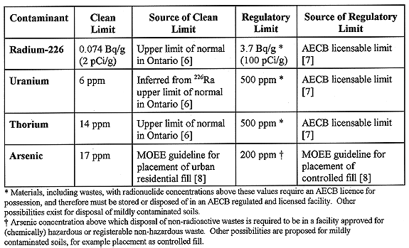
Table II summarizes the criteria selected for this study, as well as the sources from which these criteria were taken.
Table II Criteria Selected for Catergorization of Material
RESULTS
Using the criteria selected for this study, material from each of the five sites was divided into one of the three categories. In the case of Fort McMurray and Malvern, where the work has already been carried out, excavation volumes were used. Note that clean up in Fort McMurray is not yet complete, and in this case only material which has already been excavated is considered here. For the Welcome and Port Granby WMFs, the volume considered is that from the surface to the lowest depth of material which is not clean. This approximates the volume of material which would have to be excavated to remove all material which is mildly contaminated or which exceeds regulatory limits. For the Port Hope Harbour, the total volume of sediments is considered.
Table III and Fig. 3 show the results of this analysis. For three of the sites, the volumes reported here differ from those reported in Table I. In the case of Fort McMurray, the discrepancy is due to the fact that only materials which have already been excavated are considered in this analysis, whereas the larger volume reported in Table I reflects the current estimate of the total volume of contaminated material. For the Welcome and Port Granby sites, the difference is due to the particular criteria selected for this study. The volumes in Table I are those reported previously (1), and are the design waste volumes for a waste disposal facility. The volumes in Table III reflect the slightly different analysis techniques for this study. Even so, the values do not differ by more than about 10%.
Table III Volume Fractions Meeting Selected Criteria for Each of the
Sites Under Consideration

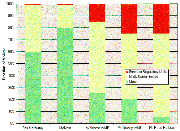
Fig. 3. Volume fractions by
category.
Another way of looking at the volume breakdown into categories is using a volume vs. contaminant concentration histogram. A specific example of this is Fig. 4, which shows such a histogram for arsenic (the primary contaminant) at the Welcome WMF. Note the remarkable similarity to Fig. 2. In this case, the upper segregation criteria was chosen to be equal to the 200 ppm MOEE guideline for placement of controlled fill. However, very little material was found to fall in the 100 to 300 ppm range. Therefore, the upper criteria could have been decreased to as low as 100ppm or increased to as high as 300 ppm without significantly impacting the distribution of volumes in the three categories.

Fig. 4. Volume vs. arsenic
concentration histogram, welcome WMF.
IMPLICATIONS
It is possible to take advantage of the particular characteristics of the volumetric inventory distributions described above. The most important feature is that a significant fraction of the inventory is often found in a disproportionately small fraction of the volume. Appropriate segregation and categorization of materials based on disposal options can lead to significantly reduced interim storage and final disposal costs. Each category of material can be treated in a manner appropriate to its potential hazard (9).
An important factor is the selection of the segregation criteria. As discussed earlier, there is often little choice in the selection of the lower criteria. However, the upper criteria is often quite flexible. Taking again the example case of the Welcome WMF, the upper criteria could have been set anywhere from approximately 100 to 300 ppm without significantly impacting the distribution of volumes in the three categories (see Fig. 4). Choosing a criteria somewhat lower than the legislated limit means that characterization methods need not be as precise to ensure compliance. Therefore, characterization costs can be kept to a minimum without significantly impacting future disposal costs.
Once segregation criteria are selected, and volumes in each of the categories calculated, the implications for a particular project become clearer. At the Fort McMurray and Malvern sites, where much of the contamination was in the form of discrete artifacts, the licensable fraction makes up less than one percent of the total volume. Segregation of this material means a dramatic potential reduction in future disposal costs. Although not to the same degree, the same potential exists at the other three sites. There, the licensable material is contained in only 15-25% of the volume to be excavated.
SUMMARY AND CONCLUSIONS
For all of the historic low-level radioactive waste sites considered here, the volumetric inventory distributions follow the same general trend. A disproportionately large fraction of the inventory is found in a relatively small fraction of the volume. The trend is more pronounced for those sites that include contaminants in the form of discrete artifacts, but is still quite evident for the sites with only bulk contamination.
Although only historic LLRW sites in Canada are considered here, it not unreasonable to presume that this trend might also be evident at other contaminated sites (radioactive or not) throughout the world.
This trend can be useful because it may be possible to segregate and categorize the material based on disposal options. Effective segregation may lead to significantly reduced interim storage and final disposal costs since each category of material can be treated in a manner appropriate to its potential hazard.
REFERENCES