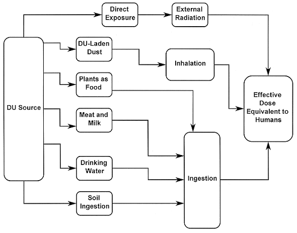
Fig. 1. Conceptual model incorporated
in the RESRAD code. Arrows indicate possible transfer of DU (after Yu et al,
1993).
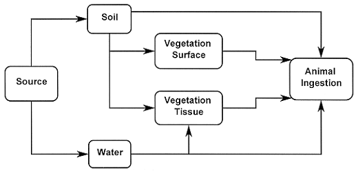
Fig. 2. Steady state model modified
to estimate DU intake by white-tailed deer.
Michael H. Ebinger
Environmental Science Group
Los
Alamos National Laboratory
Los Alamos NM
Tanya P. Oxenberg
U. S. Army Test and Evaluation Command
Aberdeen Proving Ground, MD
ABSTRACT
Jefferson Proving Ground was used by the U. S. Army Test and Evaluation Command for testing of depleted uranium munitions and closed in 1995 under the Base Realignment and Closure Act. As part of the closure of JPG, assessments of potential adverse health effects to humans and the ecosystem were conducted. This paper integrates recent information obtained from site characterization surveys at JPG with environmental monitoring data collected from 1983 through 1994 during DU testing. Three exposure scenarios were evaluated for potential adverse effects to human health: an occasional use scenario and two farming scenarios. Human exposure was minimal from occasional use, but significant risk were predicted from the farming scenarios when contaminated groundwater was used by site occupants. The human health risk assessments do not consider the significant risk posed by accidents with unexploded ordnance. Exposures of white-tailed deer to DU were also estimated in this study, and exposure rates result in no significant increase in either toxicological or radiological risks. The results of this study indicate that remediation of the DU impact area would not substantially reduce already low risks to humans and the ecosystem, and that managed access to JPG is a reasonable model for future land use options.
INTRODUCTION
Testing of depleted uranium (DU) munitions has been an integral part of U. S. Army weapons systems for over two decades (AEPI, 1995). Lot-testing of DU munitions was conducted at Jefferson Proving Ground (JPG) in southeastern Indiana until the closure of JPG in 1995 under the Base Realignment and Closure Act (BRAC). Residual DU from testing was deposited in the soils of one impact area at JPG from 1983 until 1995. Currently, efforts are underway to release the DU impact range for either restricted or unrestricted use. One part of the efforts to release the DU area was to estimate the potential for causing adverse effects to the ecosystem and humans using the area from exposure to DU fragments remaining in the soil. This paper discusses the methods used to evaluate and quantify the possibility of adverse effects to white-tailed deer and humans from exposure to DU, the results of the evaluations, and the risk-based recommendations for release of the JPG DU impact area.
The evaluation of potential risks of adverse effect to ecosystems and humans requires extensive data on the occurrence of DU in the affected area as well as application of pathway analysis models. The environmental data come from the routine radiation monitoring program at JPG and covers the period from 1983 through 1994 for this analysis. Surface radiation survey data also were used for the risk evaluation (SEG, 1995, 1996). The RESRAD code (Yu et al, 1993) was used to evaluate the potential radiological doses to humans at JPG under three land-use scenarios discussed below. In addition, a site-specific model of DU uptake by white tailed deer was developed in order to evaluate possible radiological and toxicological doses to deer. The monitoring data and surface survey data were used as input to the models and risks of adverse effects to humans and deer were estimated.
METHODS
Exposure of humans and various ecosystem components to DU fragments was modeled using pathway analysis methods and site-specific data. This paper presents the results of the human health and ecosystem risk assessments and was conducted to evaluate if the JPG DU impact area could be released for restricted or unrestricted use after closure of JPG. The remainder of this paper will develop and discuss the risk assessments and conclusions drawn from the risk assessments with regard to the release of the DU impact area.
ENVIRONMENTAL MONITORING DATA
Environmental radiation monitoring (ERM) data were reported biannually by JPG personnel. These data consist of radioactivity measurements from soils, groundwater, surface water, vegetation, and wildlife within the DU impact area and in surrounding areas (U. S. Army, 1983), and the data were summarized in a separate report (Ebinger and Hansen, 1996a). The data showed that DU was found in soils and possibly in surface water and groundwater on occasion. These data were compiled into formats compatible with the pathway analysis models discussed below.
RADIOLOGICAL SURVEY DATA
Recent decommissioning efforts were supported by radiological surveys completed in 1994 and 1995 (SEG, 1995, 1996). These surveys provided radiological dose rates at the surface of the soils within the DU impact area. Additional data collected during the surveys included the radioactivity in soil and water samples and in some vegetation samples. The additional data were collected to correlate radiation exposure-rate data and actual concentration in soils and water. The survey data were combined with the ERM data and used in the pathway analysis models. The survey data were also used to estimate the size of the contaminated area, an important parameter in the RESRAD estimates of radiological dose to humans.
PATHWAY ANALYSIS MODELS
RESRAD (Yu et al, 1993) is an analysis model developed by the Department of Energy for evaluation of the possible effects to humans of residual radiation at different sites. Figure 1 shows the RESRAD conceptual model of the pathways for human exposure by DU ingestion, inhalation, and external exposure to radiation. Three scenarios were developed in order to test a range of possible exposures at JPG. The first scenario is for occasional use of the area by day hikers or hunters. Site access was limited to two 2-week periods each year. Game animals collected within the impact area by hunters were consumed as part of the hunter's normal diet, and the radiological dose to the hunter was estimated. The site user was not allowed to consume water derived from JPG sources.
The second and third scenarios were farming scenarios. In the first farming scenario resident farmers grew crops and livestock on the impact area and consumed the vegetable and diary products from the farm. Use of local, potentially contaminated groundwater for human drinking water was not allowed in this scenario. However, contaminated drinking water was used for a fraction of the livestock water with the balance from uncontaminated surface water. The third scenario was similar to the second except that water from a potentially contaminated groundwater source on site was used for human drinking water.
Assessment of potential ecosystem effects from exposure to DU was conducted using a steady state model for estimating exposure to radionuclides by cattle (NCRP, 1984). We modified the cattle model in order to estimate the DU exposure by white-tailed deer, although the model does not account for physiological modifications to absorbed doses such as biological residence time of DU.
The steady state model is shown in Fig. 2. The main input variables for the steady state model are the DU concentrations in soils, water, vegetation, deer body mass, and the amounts of vegetation consumed as food and volume of water consumed. Distributions of food ingestion rates (Alldredge et al, 1974; Mautz et al, 1976; Robbins, 1983), water intake (Lautier et al, 1988), deer body mass (Deblinger et al, 1992), soil ingestion rates (Arthur and Alldredge, 1979; Arthur and Gates, 1988), and DU concentrations in soils and water (SEG 1995, 1996; Ebinger and Hansen, 1996a) were derived and used as inputs to the steady state model.
Fig. 1. Conceptual model incorporated
in the RESRAD code. Arrows indicate possible transfer of DU (after Yu et al,
1993).
Fig. 2. Steady state model modified
to estimate DU intake by white-tailed deer.
Three types of simulations were conducted with the steady state model. Simulation A used the minimal data set of the amounts of food, water, and soil ingested by deer, with DU concentration as constants. In Simulation B, soil concentration of DU was added as a variable. Soil concentrations of DU were distributed between 35 pCi/g and 300 pCi/g with a most likely value of 91 pCi/g. The 35 pCi/g was the NRC license agreement concentration for release of the site, 300 pCi/g represented 75% of all soil concentrations measured (SEG, 1996), and 91 pCi/g was the average soil concentration (Ebinger and Hansen, 1996b). Simulation C was the most conservative assessment and assumed a uniform distribution of DU concentrations in soil from 35 pCi/g to 700 pCi/g. The concentration of 700 pCi/g was approximately the average soil concentration reported by SEG (SEG, 1996).
Uncertainty Analysis
Formal uncertainty analyses for the RESRAD model were not conducted because of the complexity of the model (Ebinger and Hansen, 1996b). However, the input conditions were developed in order to show the effects of a range of factors on the predicted doses to humans. Instead of a probabilistic estimate of doses to humans, the RESRAD results show an expected range of doses. Because the conditions simulated represented the extremes of possible inputs, the predicted doses were expected to bound the actual doses received should the area come under farming. While significant doses were suggested under some input conditions, little actual dose is expected because the scenarios that resulted in the largest doses are not realistic.
The steady state model was developed to accommodate uncertainty analyses. We obtained distributions of expected values for each of the variables in the steady state model, then used these distributions in Monte Carlo simulations with the steady state model. The results of each simulation were a distribution of the predicted intake of DU by white-tailed deer. Expected values and/or confidence intervals were constructed for the predicted intake distributions, and risk of radiological damage and toxicological damage were estimated. Detailed treatment of the uncertainty analysis for the steady state model is given elsewhere (Ebinger and Hansen, 1996b).
RESULTS AND DISCUSSION
Table I shows the distribution of dose rates predicted from the input distributions, and Fig. 3 shows the distribution of the predicted dose rates for one set of simulations (see Ebinger and Hansen, 1996b, for all input and output distributions). Although the dose rate distributions varied in form and in selected statistical measures for each simulation (Table I), the largest dose rates were well below levels of concern for possible reproductive effects on deer (IAEA, 1992). Radiological dose rates were transformed to toxicological doses by converting the activity concentration that was ingested into a mass concentration using the specific activity of DU of 0.37 pCi/µg. The highest toxicological dose to deer was about two orders of magnitude lower than the threshold for nephrotoxicity in various organisms of 1 mg-U/g-kidney (Wrenn et al, 1985; Yuile, 1973; Zhao and Zhao, 1990). The tissue concentrations of DU predicted with the steady state model agreed well with the tissue concentrations of U in white-tailed deer harvested at the Aberdeen Proving Ground (Ebinger et al, 1996), and provide indirect support of the low radiological and toxicological doses to deer at JPG.
Table I Selected Statistics from Steady State Model Simulations to
Predict Dose Rates to Deer from DU Ingestion
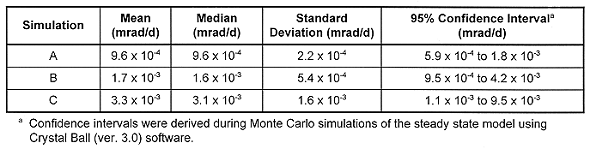
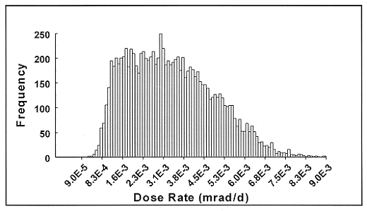
Fig. 3. Results from steady state
model, Simulation C. Graph is the frequency distribution of predicted dose rates
to white-tailed deer. Soil concentration, deer body mass, and feed intake are
the parameters that were varied in this simulation.
Current hunting programs at JPG result in removal of white-tailed deer, turkey, and other game animals. Due to a large number of unexploded ordnance, however, hunting is restricted to areas outside of the DU impact range. The results of the steady state model suggested that there is no significant risk to humans from consuming the game animals taken from areas in or near the DU impact range. Thus, doses to humans by way of ingestion of DU from game are expected to be lower than predicted using the results of the steady state model.
RESRAD results for each scenario are summarized in Table 2 and shown in Fig. 4 for Farming Scenario #2 (see Ebinger and Hansen, 1996b, for complete RESRAD results). Results from the Occasional Use Scenario suggest that minimal dose to humans occurs as a result of visiting the site for two 2-week periods each year. Inhalation of DU-containing dust was the largest contributor to the total dose expected as a result of occasional site use. Farming Scenario #1 results suggested that minimal dose to humans occurs when the water used for livestock is not contaminated. The dose to humans increased to about 47 mrem/y when well water contained 2 pCi/L U and was 10% of the livestock water supply, and 1987 mrem/y when 50% of the livestock water was contaminated with 2 pCi/L U. In Farming Scenario #2 and when no contaminated water was used, the first dose to humans was about 12 mrem/y and occurred at the beginning of the simulation. This initial dose was due solely to inhalation of DU-containing dust. A similar dose occurred at about 750 years into the simulation due to DU leaching through soils into the water supply wells. Doses increased dramatically when water with DU concentrations were 2 pCi/L and the percentage of contaminated water in the drinking water supply ranged from 10% to 50%.
Table II Maximum Doses and Times of Occurrence from RESRAD
Simulations.
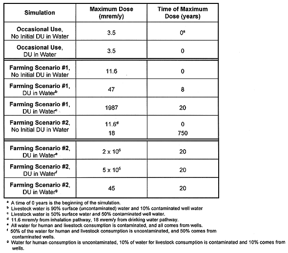
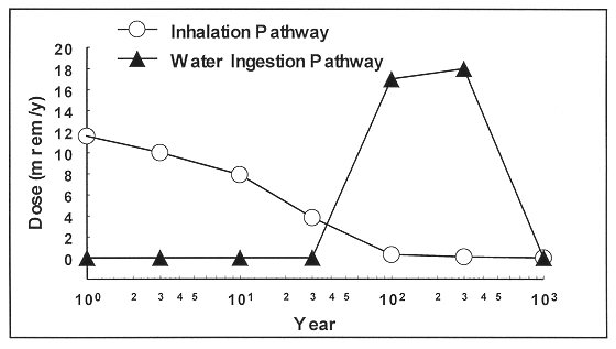
Fig. 4. Results from RESRAD
simulation of Farming Scenario #2, with no DU initially present in groundwater.
Dose to humans is from inhalation (early in simulation) and drinking water
(later in simulation).
Farming at JPG is unrealistic because of the large number of unexploded ordnance in the DU impact area and throughout the northern portion of the reservation. Without extensive and costly remediation of the ordnance areas, the risk of injury or death due to accidents with unexploded ordnance is much greater than the risk of cancer incidence or nephrotoxicity due to exposure to DU fragments. The farming scenarios presented above are intended to illustrate the possible adverse effects of different land use options.
CONCLUSIONS
The results of the steady state model showed that there is little expected adverse effect to deer from ingesting DU from vegetation, soil ingestion, and water. The model results showed that the soil concentration and the amount of food consumed by deer, respectively, affect the predicted dose to deer the most, with a small contribution from soil ingestion and almost no contribution from water consumption. The steady state model showed considerably less dose to deer than suggested in the RESRAD simulations because water consumption rates for deer were less than those for cattle. Also, crops were consumed by livestock and residents in the farming scenarios and not in the steady state model simulations, providing more exposure pathways in the former. Results of the steady state model also compare favorably to field data obtained from white tailed deer at Aberdeen Proving Ground (Ebinger et al, 1996). The results of model simulations and compared to field data on deer exposure to DU do not support extensive remediation of the affected area at JPG. In other words, the high cost of remediation would produce only small benefit by reducing already low risk estimates.
The RESRAD simulations indicate different potentials for adverse effects to humans, and the possibility of adverse effects depends on land use. The results of modeling the occasional use scenario suggested that increased adverse effects could not be measured in occasional visitors to the affected area who consume all game animals hunted at the site. These results suggested that hunting programs at JPG could continue without endangering the health of site users due to DU exposure.
Intensive use of the affected area for farming, however, increased the predicted risk of DU exposure significantly. Increased time on the site resulted in slight increases in DU ingestion mainly through the inhalation pathway. Large increases in doses to humans occurred when: 1) meat and vegetables produced on-site are consumed by the resident farmers; and 2) residents used local groundwater that had been contaminated with DU for drinking water. As mentioned above, doses to humans increased significantly even when drinking water is uncontaminated but livestock consume contaminated water and food. Thus, intensive use of the impact area for farming is not recommended.
The results of ecosystem modeling and human health effects modeling suggest that managing the JPG site as an occasional use area would create a public resource with little additional risk of adverse effects due to exposure to DU. The occasional use scenario is a plausible land-use option at JPG for either hunting, wildlife viewing, or both. Such a land use would provide additional public land in the state of Indiana and could be supported without additional remediation efforts at least for DU. There would be little remediation of the DU impact area required since the risks of adverse effects to humans or ecosystem components is low. Managing access to areas with unexploded ordnance would require remediation, but the details of such remediation is beyond the scope of the current investigation.
Use of JPG as a family farm is not recommended without extensive remediation, both of DU fragments and unexploded ordnance. Farming increases the possibility of exposure of humans and livestock that would use the DU impact area as farmland.
REFERENCES