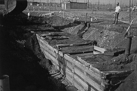
Fig. 1a. Photograph showing 116-B-5
exposed crib.
Nancy Werdel
U.S. Department of Energy
Richland
Operations Office
Glenn Van Sickle
Bechtel Hanford, Inc.
John April
CH2M HILL Hanford, Inc.
ABSTRACT
This paper presents the findings of the 100-B/C Demonstration Project conducted at the U.S. Department of Energy's Hanford Site in southeastern Washington State. The purpose of the 100-B/C Demonstration Project was to initiate remedial action in the 100 Area source sites and to address uncertainties in the remedial design planning. A series of objectives, defined through the Data Quality Objectives (DQO) process, were addressed during the excavation of three waste features. In addition, the opportunity to implement two new technologies was taken. These technologies consisted of advanced characterization using both the sonic cone penetrometer and gamma logging to delineate contamination boundaries during remediation of the 116-B-4 site and using the SonSub™ soil excavator during the 116-C-1 site excavation.
This project initiated remediation for the source sites at the Hanford Site and paved the way for the larger remediations in the 100 and 300 Areas. The lessons learned during the implementation of this project benefited the remedial designs and procurements for these larger projects and will benefit professionals involved in remediation throughout the U.S. Department of Energy complex.
BACKGROUND
In 1988, the mission at the Hanford Site changed from producing weapons-grade plutonium to environmental cleanup. Since then, much of the work in the Hanford Environmental Restoration Program has focused on the assessment phase of the Comprehensive Environmental Response, Compensation, and Litigation Act of 1980 (CERCLA) process. In late 1994, the Environmental Protection Agency - Region 10 (EPA), the Washington Department of Ecology (Ecology), and the U.S. Department of Energy - Richland Operations Office (RL) held discussions on how best to address issues related to issuance of the first Record of Decision (ROD) for the 100 Area cleanup at Hanford. Out of these discussions came the concept of conducting a demonstration project prior to issuing the ROD that would address the major uncertainties by initiating remedial action in the 100 Area.
An engineering evaluation and cost analysis was performed on the 116-B-4, 116-B-5, and 116-C-1 sites within the 100-B/C Reactor Area prior to the start of the 100-B/C Demonstration Project. This was submitted for a 30-day public comment period. On June 28, 1995, an action memorandum for the response action was issued by EPA.
In the early spring of 1995, meetings were held among the EPA, Ecology, and RL to discuss the concept of the demonstration project and to outline the objectives and expectations to address environmental restoration uncertainties. This activity was initiated in conjunction with the ongoing Streamlined Approach for Environmental Restoration (SAFER) Pilot Program for the 100-B/C Area.
The SAFER approach adopts the observational approach developed by the geotechnical engineering discipline in the 1930's and the seven-step DQO concept. The first approach basically promotes getting more information through data and field investigation and, based on this information, initiate planning that would address the uncertainties faced by the engineer. The second approach formulates the process of placing boundaries on the problem to keep from expending resources to address unnecessary uncertainties. These two approaches are combined in the SAFER process.
The SAFER process was used to facilitate the discussion process with key stakeholders. With this input the project objectives were developed. These objectives mainly focused on the uncertainties that each stakeholder was facing. The project objectives were as follows:
FIELDWORK
Source sites to be remediated during the demonstration project were selected based on their ability to help meet the above objectives. The 116-B-5 site was selected because it was believed to be a "shallow" contaminated site, the 116-B-4 site was selected based on its size and depth to remove the engineering structure, and the 116-C-1 site was selected based on its classification of being a deep site which would test the excavation stopping rule and groundwater impacts.
During the planning phase of the demonstration project, conceptual models were developed for each site to determine the best approach for remediation. These conceptual models were based on process knowledge/history of the B Reactor, process history of the selected sites, and information compiled in the limited field investigation.
The SAFER process was also applied to identify potential field conditions that could be encountered that could alter the decision process during the course of remediation. Subsequent to identifying these decision rules the planning phase was finalized so that a remedial action subcontractor could be procured.
116-B-5 Site
The 116-B-5 Crib began operation in 1950 to receive liquid waste from the 108-B Building associated with the B Reactor (first full-scale operating reactor in the world). The crib received effluent associated with the P-10 Tritium Separations Project for the Weapons Program. It was estimated that hundreds of liters of mercury were disposed of in the 116-B-5 Crib along with solvents and degreasers, such as carbon tetrachloride, methyl alcohol, and trichlorethylene. Other contaminants of potential concern included chromium and barium.
The use of conceptual site models provided an excellent tool for remedial action planning. This allowed physical and chemical data needed for contingency planning to be organized for effective remedial action decision making. Although a significant amount of information was available for the demonstration sites, a fair amount of work is required to sift through this data to support the specific objectives of remedial action planning.
What was encountered during remediation fit the conceptual model; however, the levels of contamination encountered during remedial action did not exceed preliminary remediation goals. The crib structure was removed, and verification sampling was performed. Tritium levels were tested to allow for free release of the concrete rubble material. During the planning phase it was thought that there would be approximately 300 m3 of waste generated during remedial action. There were no waste materials generated and excavated material was used for backfill. Figures 1a and 1b show the exposed crib structure and completed site excavation.
Fig. 1a. Photograph showing 116-B-5
exposed crib.
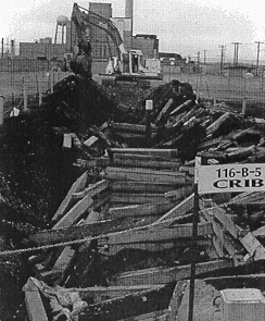
Fig. 1b. Excavation/demolition of
116-B-5 crib.
Clean up verification was performed using the RESidual RADioactivity (RESRAD) model to verify clean up criteria for radionuclides of 15 mrem/hr for the upper 4.6 m (15 ft) of the waste site. Also, the Model Toxics Control Act (MTCA) Method B clean up criteria was verified by evaluating levels of hazardous constituents to clean up levels for each of these constituents.
116-B-4
The 116-B-4 French Drain, was located east of the B Reactor Building. The waste site operated from 1957 to 1968 and received liquid discharges from decontamination of aluminum spacers and dummies used to maintain the position of fuel in the B Reactor. Decontamination fluids were neutralized and discharged to the French drain. It is estimated that the French drain received 300,000 L of contaminated chromic and nitric acid solutions from the dummy decontamination wash pad at the B Reactor. Other contaminants of potential concern consisted of Plutonium, Europium, Cobalt and Cesium.
During the planning phase it was thought that the French drain consisted of a 4 foot in diameter annulus that extend to twenty feet below existing grade. The total yardage estimated for removal consisted of 30.6 m3 (40 yd3). However, after initial excavation it was determined that no engineering existed, but that native/disturbed soils were used to receive effluent. This created a larger area and depth which the effluent could move through the soil profile. This resulted in the 30.6 m3 (40 yd3) estimate to increase to an actual volume of 3,060 m3 (4,000 yd3). Figure 2 shows the site set up at the 116-B-4 site.
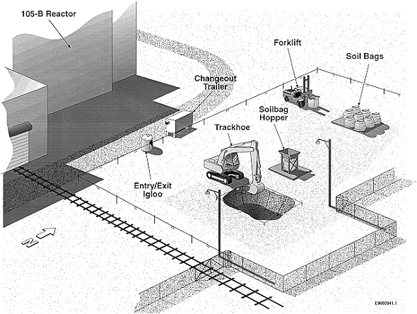
Fig. 2. 116-B-4 site setup.
The initial excavation consisted of a 6.1 by 4.3 by 6.1 m (20 by 14 by 20 ft) deep excavation. At this stage of the remediation it was determined that additional information was needed before excavating the remainder of the site. The sonic cone penetrometer was mobilized to drive points on each side of the excavation so that gamma logging could be performed. The objective of this investigation work was to define the limits of excavation or the site so that the remediation contractor can be directed since they were working under a fix price basis. In addition to this it was also beneficial to define the limits of excavation due to the close proximity to the B Reactor Building and other nearby waste sites. This approach worked very well in providing the information necessary to support stakeholder decision process.
The final excavation consisted of a 27.5 by 21.4 by 6.1 m (90 by 70 by 20 ft) deep excavation. RESRAD modeling was used to verify cleanup criteria for radionuclides. In addition, data from confirmation sampling was used to verify that MTCA Method B clean up criteria was met. Subsequent to performing this the excavation was backfilled.
116-C-1
The site consisted of an unlined 15.3 by 152.5 m (50 by 500 ft) long trench that received effluent from the retention basins during B Reactor cladding failure during operations. Approximately 169 billion liters (44.5 billion gallons) of high activity cooling water was diverted to the 116-C-1 Trench during operation form 1952 to 1968. The trench was backfilled with sand and cobbles and was marked by a depression near the center of the trench. Precise design information for the trench was unavailable because of poor record keeping at the time of trench construction.
The conceptual model for the site was built based on ground penetrating survey, old photographs during operation, and process information for the B Reactor Building. The ground penetrating radar revealed an effluent pipe system at approximately 7.6 m (25 ft) below grade which conveyed effluent from the retention basins. In addition the approach used at the 116-B-4 site was applied at the 116-C-1 site. The sonic cone penetrometer and gamma logging was used to perform advanced characterization at the 116-C-1 trench to delineate the site and gain useful information for planning for contamination at depth. It was planned to evaluate the information gathered from advanced characterization against what was actually found to calibrate the approach for other investigation for future sites in the 100 Area. Figure 3 shows the excavation operation set up for the 116-C-1 site during remediation.
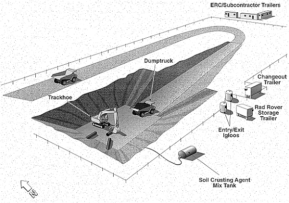
Fig. 3. 116-C-1 site setup.
RESULTS
The remainder of this paper will discuss the results of the demonstration project from the standpoint of expectations developed during planning and what was actually found during remediation. It will also focus on the most significant objectives and what was derived from this information. In addition this paper will include discussion of technologies demonstrated during implementation of this project.
Cost Model
The original plan was to validate the Micro Computer Assisted Cost Estimating System (MCACES) cost model using data collected during the demonstration project. However, as the project began, it was decided to revise the cost model, thus validation was not possible. The demonstration project, however, did contribute cost data to the MCASES revision.
As seen in Table I, the original cost estimate per cubic yard as reported in the 100-BC-1 Focused Feasibility Study Report was $401/LCY (loose cubic yard). This estimate includes transportation and disposal. The revised MCASES model, using data from 116-C-1 fieldwork, which reduced the cost to $71/LCY (includes transportation and disposal). The actual cost seen from the demonstration project, however, shows a cost of $116/LCY (transport and disposal not included). The higher cost is believed due to the startup nature of the demonstration project. Additionally, the specifications to the subcontractor were written with more direction from the contractor than full-scale remediation would require. Full-scale remediation will experience efficiencies over the demonstration project.
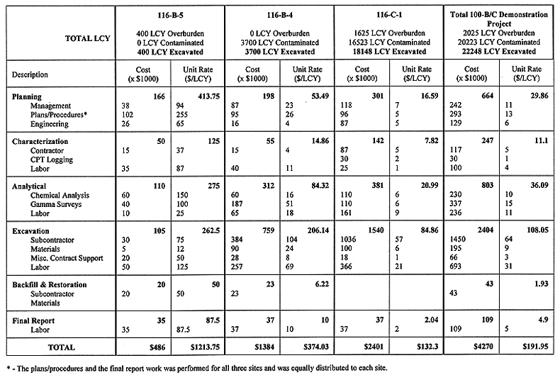
Table I 100-B/C Demonstration Project Costs by Phase
Observational Approach/SAFER
The project confirmed the value of using SAFER. This approach provided the framework for the stakeholders to understand the risks involved in starting early action without having final cleanup criteria and other uncertainties defined. It provided the necessary boundary conditions to initiate action without having all of the answer, but was used to remediate, get more data, evaluate against uncertainties and change the models to facilitate effective planning for future site remediation in the 100 Areas.
Stopping Rules
Stopping rules (i.e., when to stop digging) were evaluated against stopping rule criteria developed during proposed plan preparation and ROD negotiations. These criteria were developed to address when and how much contamination do you leave based on other criteria that could impact when to stop digging. These criteria are reduction of risk by decay; protection of human health and the environment; cost to continue remediation (weighed with other factors) available disposal space at the disposal facility; work safely; presence of or potential impact to cultural and natural resources; use of institutional controls; and long term monitoring cost.
During the demonstration project, additional data was gathered for the stakeholders to evaluated, discuss and therefore better understand when these rules are implemented. However, each element of the balancing factors were not tested due to site conditions revealed during site remediation of the demonstration sites.
Sonic Technology
The use of the Sonic Cone Penetrometer with gamma logging proved to be successful in obtaining advanced characterization data for all of the demonstration sites. For example, on the 116-B-4 site initial excavation revealed that the contaminated soils were not completely excavated. This site was near the historical B Reactor. Use of the sonic cone penetrometer provided boundary data which showed the contamination stopped 4.6 m (15 ft) north, south and east of the initial excavation. However, contamination did extend west near the B Reactor Building. This provided the information necessary for the stakeholders to decide on site boundaries for determination of site remediation of the 116-B-4 site. Figure 4 shows the sonic drill rig at the 116-B-5 site. This tool was used at the 116-B-5 and the 116-C-1 sites and provided advanced data for planning the excavations. In addition, this technology was also used for the Group 1 sites remediation planning for the 100-B/C Area. The Group 1 sites contain approximately 300,000 LCY of radioactive contaminated soils.
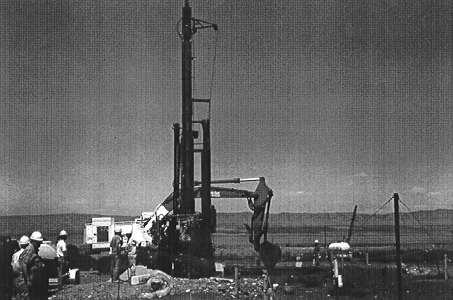
Fig. 4. Photograph of resonant sonic
rig at 116-B-5.
SUMMARY
The 100-B/C Demonstration Project helped answer many questions and uncertainties related to the cleanup of waste sites at Hanford. More complete discussions of the results are found in the 100-B/C Demonstration Project Final Report (April, et al., 1996). It should be noted that many of these results, such as design information, logistical data, and analytical results were transferred immediately to the Group 1 remedial action project. Finally, the greatest contribution of the demonstration project was showing that risk can be managed when addressing remediation uncertainties by executing the observational approach.
BIBLIOGRAPHY
APRIL, JOHN G. et. al, 100-B/C Demonstration Project Final Report, BHI-00752, Rev. 0, Bechtel Hanford, Inc., Richland, Washington, (1996): 4-22 --25.