Table I Summary of hazards for public use of DOE site in Nevada
based on the NRAMP Preliminary Risk Assessment results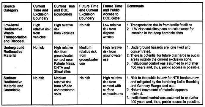
W.B. Andrews
Senior Program Manager
Pacific
Northwest National Laboratory
E. J. Bentz
President
EJ Bentz & Associates (EJB&A)
D. H. Baepler
Harry Reid Center for Environmental Studies (HRC)
University
of Nevada Las Vegas (UNLV)
C. B. Bentz
EJB&A
A. Hechanova, P. A. Jonker, T. Johnson, M. D. Pandian, and D. D. Weber
HRC,
UNLV
ABSTRACT
The team of the Harry Reid Center for Environmental Studies (HRC) at the University of Nevada Las Vegas and the firm of E. J. Bentz & Associates (EJB&A) of Springfield, VA was awarded in April 1995 a cooperative agreement by the US Department of Energy Environmental Management Program Office of Science and Risk Policy (EM-52) to conduct an independent stakeholder-based risk assessment and risk management evaluation of environmental management activities in Nevada and to transfer this experience to other sites. The NRAMP is demonstrating the application of risk assessment and risk management techniques with direct stakeholder involvement.
No significant radiological hazards to the public were identified at the present time due to institutional control of the current combined DOE and U.S. Air Force exclusion area. However, hazards would be severe if public access occurs to underground contaminants from underground nuclear tests. Access to these contaminants would require drilling and removal of the contaminants to the site surface. Hazards from ground disturbing human uses of areas with surface contaminants at the Nevada Test Site are significant on at least 10 percent of the Nevada Test Site at the present time and significant hazards exist at portions of the current NTS border from surface contaminants.
The PRA does not answer all technical concerns. Complete information on NTS contaminants is not publicly available because information on nuclear weapons source terms remains classified. Long time-frames (more than 100 years) have yet to be addressed. Radiological contaminants will exist at hazardous levels for thousands of years at DOE sites in Nevada. Future waste storage volumes and forms at the NTS are not known and are the subject of current policy discussions.
The PRA does not answer all stakeholder concerns. Comprehension of risk assessment information is difficult because of its voluminous and technical nature. A technical risk assessment cannot address all stakeholder concerns. This limitation is because of weaknesses in current risk assessment techniques as well as the vast range of stakeholder interests. The goal of developing a broad participation and a public consensus is also elusive. Diverse opinions have been expressed and recorded, but consensus has not been achieved.
BACKGROUND
The Nevada Risk Assessment / Management Program (NRAMP) is a joint effort of the University of Nevada Las Vegas - Harry Reid Center for Environmental Studies and the firm of EJ Bentz and Associates to develop new sources of information and approaches to risk assessment, risk management, risk communication and public outreach as these objectives relate to the ecological and human health effects of radioactive and hazardous waste site remediation and waste management activities. NRAMP is being conducted using a cooperative agreement with the U.S. Department of Energy's (DOE) Environmental Management Program - Office of Science and Risk Policy (Cooperative Agreement No. DE-FC01-95EW55083).
The Preliminary Risk Assessment (PRA) is a first effort by the NRAMP to apply a risk assessment process with public involvement as described in the National Research Council's report, Building Consensus Through Risk Assessment and Management of the Department of Energy's Environmental Remediation Program to sites in Nevada. Major themes of the NAS's recommendations include working closely with stakeholders to develop credible independent assessments of risks at radioactive and hazardous waste sites and to evaluate options for site restoration and future land use from the perspective of stakeholders. Specific objectives of the NAS recommendations addressed in the PRA are to provided information on the risks to human health, identify data gaps and uncertainties and find methods for filling or reducing them, recommend ways that identified risks can be reduced, and recommend how public participation should be part of risk evaluation.
Stakeholders contributions to the basis of the PRA were to refine the NRC recommendations on the communication of information in ways that could be understood by the public, develop a comprehensive list of what they wanted to know about DOE sites in Nevada and to seek ways where they could "make a difference" in decisions related to the future of DOE sites in Nevada. Not all identified stakeholder issues were addressed in the PRA due to limited information and resources. Ecological risk, worker risk and time frames beyond 100 years, for example, may be considered in future NRAMP activities. Some stakeholder interests, such as equity in waste disposal and land ownership by Native Americans, are beyond the scope a risk assessment. However, discussions of these issues may benefit from credible and comprehensive risk information.
The combination of scientific recommendations by the NAS and stakeholder interests in specific information about DOE sites in Nevada is the basis of this paper. For these reasons, draft PRA results were subjected to both peer review and extensive public review by both the NRAMP Public Working Group and the NTS Community Advisory Board. Results of this collaboration can be best summarized in the following sections on what we know about DOE sites in Nevada, what we don't know about DOE sites in Nevada, and recommendations for further public input.
WHAT WE KNOW ABOUT DOE SITES FROM THE PRELIMINARY RISK ASSESSMENT
Present and Historic Uses of DOE Sites in Nevada
The DOE Nevada Operations Office (DOE-NV) manages four locations in Nevada that have been used for development and testing of nuclear devices. These locations include; 1) the Nevada Test Site (NTS); 2) the Tonopah Test Range/Nellis Bombing and Gunnery Range; 3) Project Shoal Test Area, and; 4) Central Nevada Test Area (Project Faultless Site).
The Nevada Test Site, located in the southeastern portion of Nevada, is operated as the on-continent test site for nuclear weapons testing. The NTS encompasses approximately 1,350 square miles (3,500 km2) and is surrounded on the east, west, and north by the Nellis Air Force Base Bombing and Gunnery Range. Together with the Tonopah Test Range, these two properties provide a 15-mile to 64-mile (24- to 104-km) buffer zone between the test areas and public lands. The Bureau of Land Management manages federal lands on the southern and southwestern borders of the NTS. Las Vegas, the major metropolitan center near the NTS, is approximately 65 miles (100 km) from the southeast corner of the site. Prior to withdrawal of the these lands from public use, there was a long history of human use as indicated by the large number of prehistoric and pioneer sites within the NTS borders.
Nuclear weapons have been tested in the atmosphere, near surface and underground in Nevada. Between January 27, 1951 and July 17, 1962, a total of 100 atmospheric tests were conducted on the NTS. In addition, between 1951 and 1968, 13 nuclear tests were detonated close to the surface, which resulted in throw-out of earth upon explosion (referred to as "crater" shots). A total of 815 underground nuclear tests were conducted in Nevada between 1963 and 1993. Approximately 260 of these were conducted below or near the water table. Large areas of surface, near-surface and subsurface radioactive contaminants remain from these activities.
There are two low-level radioactive waste (LLW) disposal sites located on the NTS, one in Area 3 and another in Area 5. The Area 3 Radioactive Waste Management Site (RWMS) has been operating since the late 1960's. The Area 3 RWMS was built in the location of seven nuclear subsidence craters that were created as a result of underground nuclear tests. To date, four craters have been used for waste disposal. The "U3ax/bl" disposal unit operated from the late 1960's until 1987 and accepted mostly bulk wastes from the cleanup of NTS sites previously contaminated by atmospheric testing. The wastes are mostly in the form of contaminated soil and scrap metal debris from nuclear test operations. The U3ax/bl unit is currently awaiting final closure. A second disposal unit " U3ah/at" is currently operating. This unit is currently accepting wastes from NTS and TTR cleanup in addition to wastes from other sites in the DOE system.
The Area 5 RWMS has accepted non-bulk packaged LLW from on-site since 1961 and began accepting off-site DOE waste in 1978. The majority of wastes in the Area 5 RWMS are disposed in shallow burial trenches. The Area 5 RWMS is also home to the Greater Confinement Disposal (GCD) boreholes, which are used primarily to dispose of high activity wastes (e.g., tritium and 90Sr) and transuranic wastes. Transuranic wastes in the GCD facility contain waste forms that are not suitable for disposal in the Waste Isolation Pilot Plant (WIPP) near Carlsbad, NM. Also located at this RWMS is a TRU interim storage facility that stores TRU waste to be shipped to the WIPP facility when it opens.
The Tonopah Test Range and Nellis Bombing and Gunnery Range (TTR/NBGR) is adjacent to the NTS on the west, north, and east boundaries. Five safety-shot tests (in the years 1957 and 1963) were conducted on the TTR/NBGR wherein nuclear devices were subjected to conventional explosives to determine whether the device could attain criticality under accident conditions. The yields for the five tests are all reported as zero although plutonium was dispersed into the air and onto the ground in each test.
The Project Shoal Test Area, in west-central Nevada, was the site of a 12-kiloton underground nuclear test in 1963. The device was detonated 366 meters below ground surface in granitic rocks of the Sands Springs Range. The hazardous materials evaluated in this PRA resulting from the detonation residue are the radioactive contamination in the aquifers in the area and the chemical contaminants on the surface of the site.
The Central Nevada Test Area (CNTA) is in remote desert in the south-central Nevada area of Hot Creek Valley. The CNTA is bordered on the southeast by U.S. Highway 6, approximately 60 miles (100 km) northeast of Tonopah and 110 miles (180 km) southeast of Ely. The CNTA was the site of the Project Faultless underground nuclear event, a 200 to 1000 kiloton detonation 975 meters below land surface on January 19, 1968. The hazardous materials evaluated resulting from the Faultless test in this PRA are the radioactive contamination to the aquifers in Hot Creek Valley, Nevada, and the chemical contaminants present on the surface of the site.
Basis for the Preliminary Risk Assessment
The approach taken in the PRA was to use risk assessment techniques to evaluate present and future hazards for existing contaminants. Contaminants at these sites were categorized into the following five categories:
| Source Categories | Examples |
| Industrial Sites | Chemical toxins at spill sites, waste sites, and landfills |
| Low-Level Waste Disposal | Radioactive materials in bore holes and landfills |
| Surface Soils | Soil with radioactive contaminants from testing |
| Transportation-Related | Radioactive material in shipments to the NTS |
| Underground Test Areas | Radioactive material in a subsurface test cavity |
Residual man-made radionuclides in surface soils present one of the most serious hazards to human health and the ecology at the Nevada Test Site because of the ease of access to the contamination and the fact that the contamination has reached beyond the border of the NTS. At least sixteen man-made radionuclides have been reported with elevated levels (i.e., significantly above their natural background level or, if not naturally occurring, at a concentration level of potential concern) measured in the soil, ten of which contribute significantly to short term and long term hazards.
Subsurface groundwater radioactive contamination resulted from underground nuclear tests. Risks to human health and the environment could occur if contaminated groundwater is brought to the surface. The nearest publicly accessible area in a potential direction of groundwater flow from the Pahute Mesa area is at the edge of the Nellis Air Force Range. NRAMP can only roughly estimate the radiologic source term because of data classification for national security reasons and scientific uncertainty. NRAMP used existing sampling data and estimates of inventories (modeled from the hydrologic source term) to estimate the potential risk from contaminated groundwater.
Support activities at the NTS also resulted in numerous hazardous waste sites. These sites chemical storage sites, landfills, and waste dump sites. There are 1,502 such "industrial sites" in Nevada. Of these 1,502 sites, 534 are reported as removed or cleaned. The remaining 968 sites are reported as "yet to be cleaned" or "unknown." Those reported as "unknown" are assumed "yet to be cleaned." Of the 968 sites, 740 do not have information on latitude and longitude. The remaining 228 had information on latitude and longitude. Of the 228 sites, 40 are under the waste category "Miscellaneous."
No members of the public currently live on or adjacent to contaminated DOE sites in Nevada. For this reason, a fictitious (hypothetical) public person was assumed to engage in specific activities for the purpose of this PRA. The following land use (human activities) were considered reasonable by the NRAMP public working group if contaminated lands were to be used as they have been in the past with no restrictions:
| Public Land Use Scenarios | Examples |
| Cultural | Native American ceremonies |
| Industrial | Mining for valuable ore |
| Ranching | Ranches with cattle and home-grown crops |
| Recreational | Hiking |
| Residential | Isolated housing units |
Public use of the site is currently not allowed or considered in the analysis except for controlled casual access. It was also assumed that unrestricted public access could take place after 100 years.
The use of a fictitious person to evaluate risks at DOE sites in Nevada has several strengths and weaknesses. Major strengths of this approach are that it allows a full range of possible land uses to be examined to better understand how harm could occur and what appropriate cleanup actions might be. This approach also compares the contaminant hazards on a consistent basis so that cleanup activities can be prioritized. A major weakness to this approach is that actual future land uses and exposures are not known and meaningful comparisons of this study to other studies is limited.
Results of the Preliminary Risk Assessment
General
Table I Summary of hazards for public use of DOE site in Nevada
based on the NRAMP Preliminary Risk Assessment results
Underground Test Areas
Surface Soils
Industrial Sites
Low-Level Waste Disposal Sites
Transportation-Related Sources
WHAT WE DON'T KNOW ABOUT DOE SITES FROM THE PRELIMINARY RISK ASSESSMENT
More Information Needs to be Made Available or Collected
The PRA Doesn't Answer All Stakeholder Concerns about the NTS
STAKEHOLDERS AND THE NRAMP HAVE OPPORTUNITIES TO "MAKE A DIFFERENCE"
The DOE and stakeholders are faced with a daunting number of complex decisions that will affect the future of DOE sites in Nevada. It is obvious by the size, complexity and continued federal use of the NTS that it will not be "cleaned" in the context of contaminant removal. Technology, resources, and disposal facilities for this material are not present. The DOE site remediation program does not have this goal. This situation invokes a real feeling of loss to many Nevadans and Indian Nations. Given the lack of trust in federal, state, and local government, there are strong concerns about the long-term management of these sites to avoid public health risks and financial burdens.
REFERENCES
Preliminary Risk Assessment - DOE Sites in Nevada. Nevada Risk Assessment / Management Program. Harry Reid Center for Environmental Studies, University of Nevada Las Vegas, Las Vegas , Nevada. December 1996.