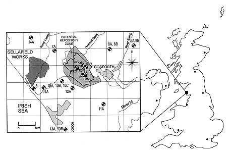
Fig. 1. Locations of
the deep boreholes at Sellafield site.
Adrian Bath
Golder Associates (UK) Ltd.
Nottingham,
NG12 4DG, UK
Anna Littleboy
Nirex, Harwell, OX11 0RH, UK
ABSTRACT
Nirex is investigating the suitability of a site in West Cumbria as a location for the deep geological disposal of solid intermediate and certain low level radioactive wastes. The host rock is low permeability metamorphosed volcanic rock overlain by Permo-Triassic sedimentary rocks. Three distinct groundwater régimes have been identified at the site.
Geochemical investigations at the Sellafield site have been carried out with the objectives of: (i) Supporting the development of conceptual and numerical models of the hydrogeology of the area; (ii) Constraining models of the fluid evolution history of the area; and (iii) Characterizing the key chemical characteristics of the groundwater that will eventually resaturate the repository after closure.
This paper focuses on the first two of these objectives by discussing the key hydrochemical features of the Sellafield site and the inferences which can be drawn from this evidence.
Determination of the spatial distribution of groundwater salinity (and hence density) is particularly important to ensure correct interpretation of measured groundwater pressures in terms of present potential for flow. Variable density groundwater flow models are required for this system. Modeled output is evaluated by comparison with observations of both groundwater head and salinities. The hydrochemistry and mineralogy of the three régimes have been used to understand the past history of groundwater movement. The distribution of salinity, stable isotopes and halide ratios have been used to understand past and present groundwater processes. Comparisons of hydrochemical data with groundwater flow modeling have elucidated the driving forces and boundary conditions prevailing at the site, and their past evolution. These interpretations can be used to refine groundwater flow models which are used in repository performance assessment.
INTRODUCTION
Geochemical investigation is one of the primary approaches to characterizing sites which are being evaluated for deep nuclear waste repositories. There are multiple end-uses for geochemical data in site characterization. One of the most important uses is in conditioning the conceptual hydrogeological models of the system, both as it is now and as it has evolved over time. This requires integrated geochemical, hydrogeological and palaeohydrogeological interpretation (Richards et al., 1996).
A conceptual hydrogeological model of a groundwater system is a hypothesis for how the system operates (Konikow and Bredehoeft, 1992). A key process in the operation of all groundwater systems is the tendency to flow in response to gravity potential. Whereas the effects of surface topography on gravity potential differences diminish with depth, the tendency of groundwaters to become saline (and thus more dense) with increasing depth may significantly modify the gravity potential. Density variations in a groundwater system are consequently a significant factor in determining flow conditions, i.e. directions and rates of flow (Lusczynski, 1961), particularly where deep groundwaters are being considered. Thus determining the chemical variations ('hydrochemistry) in a deep groundwater system is of direct relevance to present day hydrogeological interpretation, in addition to enabling the hydrochemical evolution and groundwater history to be conceptualized.
Groundwater hydrochemistry and its relationship to mineral chemistry provide an integrated record of past water rock interactions and groundwater movement. This record can be examined to elucidate past groundwater flow processes, and thus understand the hydrogeological history of the site under investigation and constrain the range of possible conceptual models.
This paper focuses on the importance of hydrochemistry in understanding the hydrogeology of a potential repository site which is located in a low permeability fractured rock in deep saturated zone groundwaters. In addition to influencing the interpretation of the densities and flow potentials in the system as it is presently configured, hydrochemistry offers evidence for how the variable density groundwaters have evolved over timescales which are comparable with those relevant to performance assessment.
THE SELLAFIELD SITE, NORTHWEST ENGLAND
Nirex is investigating the suitability of a site near Sellafield in Northwest England as a location for deep geological disposal of solid intermediate and some low level radioactive wastes. The site is on the coast of the Cumbria region, between inland hills and the Irish sea (Fig. 1). The potential repository location is in metamorphosed Ordovician volcanic rocks, the Borrowdale Volcanic Group (BVG) which lies at depth, below 300 - 400 m in the Potential Repository Zone. It is overlain by Permo-Triassicsedimentary formations (a Permian breccia called the Brockram and the Sherwood Sandstone Group) and a superficial veneer of glacial sediments. The Borrowdale Volcanic Group outcrops in the hills to the east of the Potential Repository Zone, whilst the Permo-Triassic sediments thicken westwards into the offshore Mesozoic East Irish Sea Basin. The disposition of topography and hydrogeological units causes the dominant groundwater flow to occur in a generally east to west direction (towards the coast) in the sandstone formations. Groundwater movement in the volcanic rock occurs predominantly through fractures and faults in the metamorphosed rock mass which generally has a low hydraulic conductivity (Michie, 1996).
Fig. 1. Locations of
the deep boreholes at Sellafield site.
GROUNDWATER CONDITIONS IN DEEP BOREHOLES AT SELLAFIELD
At the end of 1996, twenty seven boreholes have been drilled by Nirex in its investigations of the potential repository site. The locations of these are shown in Fig. 1. The boreholes are all within an area of about 50 km2; the deepest borehole is 1950 m deep and many extend to 1000 m depth. Groundwater pressures were interpreted from the results of short-duration drawdown and recovery tests, carried out systematically at 50 m intervals as drilling progressed. In situ groundwater pressures are being continuously measured by long-term monitoring systems (Westbay multi-packer installations) in many of the boreholes. Hydrochemical data were obtained by analyses of groundwater samples taken during longer pump-out tests carried out over discrete intervals at the completion of borehole sectors.
These investigations have shown that there are large variations of groundwater salinity at the Sellafield site (Bath et al., 1996) (Fig. 2). Fresh groundwaters occur in the shallow parts of the system, extending to the base of the sandstone in the Potential Repository Zone. In the western part of the site, where the sandstones thicken towards the basin, the fresh water zone becomes shallower and overlies increasingly saline groundwater. At depth in this region, there are brines (>60 g/l chloride) which occupy the lower part of the sedimentary sequence and the underlying volcanic rocks.
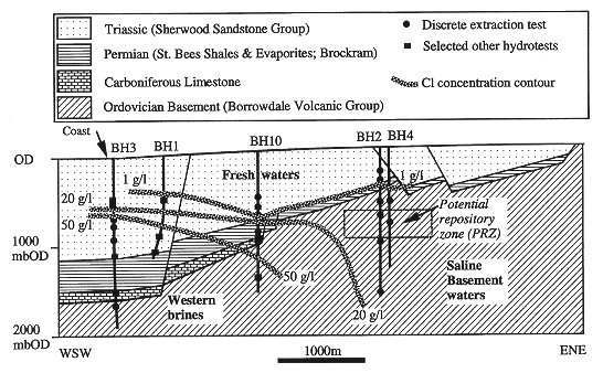
Fig. 2. Cross-section through
Sellafield Site, showing salinity distribution ('bOD' is below Ordnance Datum,
i.e. below sea level).
Groundwater in the volcanic rocks in the Potential Repository Zone is saline (up to 18 g/l chloride). The vertical transition from fresh to saline groundwaters here is associated with the lithostratigraphical boundaries (and corresponding contrasts in hydraulic properties) between basal sandstone and uppermost Borrowdale Volcanic Group. The salinity gradient in this 'Saline Transition Zone (STZ) is steep, rising from fresh water to >10 g/l chloride over a short interval. Saline groundwater is also found in the Borrowdale Volcanic Group rocks to the east of the potential site, where the sedimentary cover thins and disappears at the eastern margins of the site. Density, and thus salinity, plays an important role in determining hydraulic gradients and the inferred potential for groundwater movement. The saline groundwater in the Potential Repository Zone is subject to a topographically-controlled westward hydraulic gradient and also to an upward vertical gradient. Fresh water which occupies the shallow parts of the groundwater system flows westwards along the topographic hydraulic gradient. The principal discharge of the groundwater system is inferred to be controlled by the presence of the western brines and by intrusion of sea water into shallow sedimentary rocks offshore, both of which inhibit horizontal westwards movement of groundwater.
The observed distribution of salinities and thus of variable densities, and the inferred controls existing on directions and rates of groundwater movement, has led to an illustrative conceptual model for the groundwater system (Black and Brightman, 1996). This conceptual model (Fig. 3) is the starting point for numerical modeling of the present groundwater flow conditions. The conceptual model is also the starting point for developing interpretations of the groundwater history of the area. This is done by examination of the hydrochemical evidence for how the variable density groundwaters have evolved.
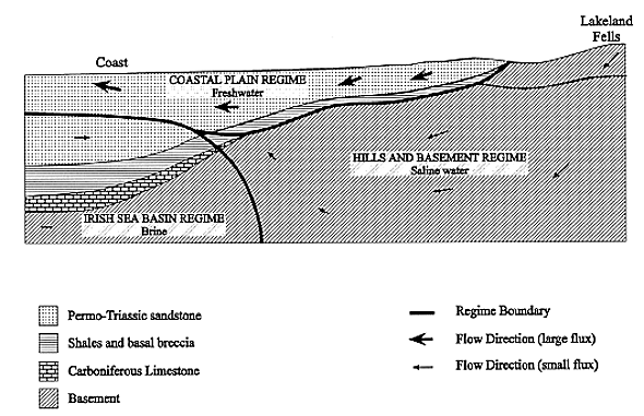
Fig. 3. Schematic illustration of
the conceptual groundwater regimes for the Sellafield area (from Black and
Brightman, 1996).
EVOLUTION OF VARIABLE DENSITY GROUNDWATERS
Evidence for the evolution of the variable density groundwaters comes from interpretation of the sources of salinity and of the origins of water in the system (Bath et al., 1996). Hydrochemical and isotopic parameters provide 'fingerprints which characterize likely sources and also resolve the mixtures which occur throughout the system and particularly in the salinity transitions. The most effective parameter for characterizing the different water sources, in terms of water source and/or probable recharge age, is the isotopic composition of the water itself (18O/16O, 2H/1H). Salinity sources are characterized by the ratio of the trace solute bromide (Br) to chloride (Cl) (which is the dominant anion solute in saline groundwaters and brines). Because the halide solutes, Cl and Br, are conservative, i.e. generally unreactive, they are also good indicators for resolving mixing relationships between different groundwater bodies.
Differentiation of salinity sources has been a significant achievement of investigations at Sellafield. As might be expected, the brines contained in the thick sedimentary sequence at the western edge of the site have Br/Cl typical of basinal brines (about 0.0010 by mass). However saline groundwaters in the basement at the eastern part of the site have higher Br/Cl(about 0.0017). The origin of this distinct basement fingerprint is thought to be salinity which has evolved geochemically from basinal brines which penetrated the inland basement in its geological past. An alternative explanation is that salinity in the basement groundwaters is derived from an entirely separate source than for the basinal brine. The existence of two distinct saline groundwater bodies has had a significant effect on the modeling of physical groundwater conditions through the implications for selecting appropriate boundary conditions for the model. Br/Cl data indicate that groundwater in the Potential Repository Zone and just downgradient contains a mixture of the two salinity sources. Groundwater modeling aims to replicate this mixing process as well as simulating the distribution of environmental groundwater heads (which are themselves dependent on the salinity-density profile at any point).
Stable oxygen and hydrogen isotope compositions of groundwaters across the
site are also significant in differentiating water sources. The light isotopic
ratios observed in all sampled groundwaters, relative to the seawater ratio,
show that the water is meteoric. Brines have isotopic compositions (e.g. around
-5 to -6‰
![]() 18O)
which are consistent with their inferred ancient (i.e. pre-Quaternary) source in
the basin. Fresh groundwaters, occurring at relatively shallow depth (for
example, occupying the sedimentary rocks in the vicinity of the proposed
repository), have isotopic compositions which are mostly similar to modern
groundwater recharge (-6 to -7‰
18O)
which are consistent with their inferred ancient (i.e. pre-Quaternary) source in
the basin. Fresh groundwaters, occurring at relatively shallow depth (for
example, occupying the sedimentary rocks in the vicinity of the proposed
repository), have isotopic compositions which are mostly similar to modern
groundwater recharge (-6 to -7‰![]() 18O),
suggesting a post-glacial age (i.e. <10,000 years). The underlying saline
groundwaters, occupying the volcanic basement in the vicinity of the repository,
have a significantly lighter isotopic composition (-7 to -8‰
18O),
suggesting a post-glacial age (i.e. <10,000 years). The underlying saline
groundwaters, occupying the volcanic basement in the vicinity of the repository,
have a significantly lighter isotopic composition (-7 to -8‰
![]() 18O).
This pattern characterizes older groundwaters whose recharge ages are
attributable to the Quaternary glacial period which prevailed in NW Europe
between about 2 million and 10,000 years ago.
18O).
This pattern characterizes older groundwaters whose recharge ages are
attributable to the Quaternary glacial period which prevailed in NW Europe
between about 2 million and 10,000 years ago.
These data, and other hydrochemical and isotopic data which support the inferences concerning salinity sources and recharge ages, lead to an interpretative model for groundwater evolution in the Sellafield area. Brines in the Irish Sea Basin sedimentary rocks (which have themselves evolved by dissolution of evaporate minerals) have invaded the underlying basement rocks and those lying to the east of the basin. More recently, at various stages of the Quaternary period, the present saline groundwaters have evolved by recharge of meteoric water followed by its mixing with brines (or the diluted relicts of brines) as the groundwaters flowed in response to gravity potential. As described earlier, the gravity potential for flow has been modified by changing salinity and density. Stratification of salinity at the present day reflects the spatial variation of cumulative groundwater fluxes depending on the transmissivities of different hydrogeological units. The most marked evidence of this is the sharp saline transition zone which is located above the Potential Repository Zone.
Thus hydrochemical and isotopic data describe the present-day system of variable salinity and density groundwaters, and suggest that the saline groundwaters occupying the Potential Repository Zone and surrounding rocks have evolved in Quaternary time by groundwater flow. The direction of flow has been controlled by an interface and zone of mixing with the basinal brines. Further evidence of this evolution is provided by the presence of zoned minerals which have grown in open fractures. These provide a record of the temporal sequence of hydrogeological/hydrochemical conditions which constitute the palaeohydrogeology of the system. Studies of drillcore samples from Sellafield show that the composition and crystal morphology of the most recent generation of fracture-lining calcite varies (Milodowski et al, 1997). These variations appear to correspond with the changes in groundwater salinity. Research is in progress to investigate whether compositional-zoning in calcite indicates similar responses of the salinity mixing zones to transient changes at the boundaries of the system as those indicated by modeling. Of particular interest is the question of whether the variable density deep groundwater system has evolved to a condition of stability with respect to the effects of climate change, i.e. glaciation, fluctuating freshwater recharge and sea level change.
MODELING OF VARIABLE DENSITY GROUNDWATERS
Groundwater flow models of the system at Sellafield have been constructed to develop further the understanding of variable density flows in the area. A range of modeling techniques have been used to explore different aspects of the site hydrogeology. The integration of model construction and calibration with hydrochemical information and understanding has enhanced understanding of the flow processes operating at the site.
Initially, 2D and 3D coupled modeling work was performed to examine the links between groundwater hydrochemical observations at Sellafield and concepts of physical hydrogeology. The majority of the work used a 2D vertical cross section model to simulate coupled flow and solute transport, using very long transient simulations to determine pseudo steady state flows for multiple sources of a single salinity type. Two sources of salinity were introduced at the eastern and western boundaries of the model. The transient effects of glacially induced sea level changes over the last 40,000 years were examined. Modeling results were compared with the detailed distributions of pressure, salinity and other hydrochemical indicators as measured in the boreholes. For the 3D work, the transition to brines to the east of the model was shown to affect the direction of flow paths indicated by particle tracking (Littleboy et al, 1996).
Matches to the heads and salinity data were improved by modification to the conceptual model. Modifications which were considered included the introduction of a small groundwater flux through the base of the model (which was placed at 3500 m depth). This might, for example, originate as a small thermal/convective flux from depth. However, in this instance, a deep crustal geochemical signature would be expected which is inconsistent with observed hydrochemical and isotopic data. An alternative modification was the incorporation of a zone of slightly increased transmissivity at the base of the model. There is no physical evidence for the existence of such a zone. However, the enhancement in transmissivity was small and was within the range that might be expected as a result of decreased viscosity as temperatures increase.
The model results were also compared with observed trends in bromide/chloride ratios (Fig. 4). Qualitative agreement was achieved with modeled ratios of mixing between groundwater from different sources although this mixing model remains qualitative because the composition of the eastern saline groundwater source is not known. Similarly, model predictions for groundwater 'age were in general agreement with estimates based on O/H isotope compositions (Fig. 4).

Fig. 4. (a) Modeled outputs for ratio
of two salinity sources and of groundwater 'ages' at the location of Boreholes
10 and 12 at Sellafield. (b) Observed Br/Cl ratios and 18O
compositions in Boreholes 10 and 12 (from Richards et al, 1996).
Evidence from the hydrochemical data indicates that the variable density system has evolved with time. Further modeling work was therefore conducted on three sub-parallel cross sections to simulate the transient transport of salinity, either from one or two sources of salinity. Sensitivities to changes in boundary conditions were also examined (for example boundary condition changes that represented ice loading and changes to recharge).
The modeling indicated that none of the steady state simulations using a single source of salinity was able to match simultaneously the borehole measurements of both groundwater pressure and salinity. Conceptual model changes similar to those described above (incorporation of a zone of slightly enhanced transmissivity to the base of the model) improved the match. Best results were obtained by transient simulations which incorporated a second source of saline groundwater. This was modeled by allowing equilibration of the deep basinal brine in the west with an eastern source of saline groundwater. The eastern source was then switched off in the model and the transient flow system produced during 1 million years of freshwater recharge was simulated. Inspection of the results showed that the best match to existing data was obtained after approximately 12,000 years of freshwater recharge.
A third modeling study was also performed to test the hypothesis that the observed pressure and salinity at Sellafield are the result of basin evolution. The modelling used a combination of 2D and 3D simulations to describe the geological evolution of the site from the end of the Carboniferous period. The model indicated that the deposition of Triassic halite-containing mudstone beds (the Mercia Mudstone Group) would have resulted in a basin filled with dense brine derived from the dissolution of halite. At the end of the Triassic period this brine occupied all the sedimentary sequence and the underlying basement rocks, including those beneath the eastern massif. This model result is consistent with the hypothesis that the observed salinity with a basement fingerprint is historically derived from the western brine, subsequently modified by water-rock interaction and dilution, producing a hydrochemically distinct groundwater body.
The conditions at about 2 million years ago as predicted by this brine migration model were used as initial conditions for a simulation that applied transient boundary conditions to the top surface to represent changing sea levels during a glacial/post glacial cycle. The result from this calculation compares reasonably with the observed pressures and salinities at the boreholes.
This modeling work has enabled an improved conceptual understanding of the past and present groundwater flow processes at Sellafield to be developed. This has suggested that the site hydrogeology has evolved as a result of the migration of brines from the basin across the site in the geological past. These brines have subsequently been modified into a distinct groundwater body. Processes such as the effects of glaciation have acted on the system to develop a more actively circulating groundwater body nearer the surface. This conceptual understanding can be applied to transient modeling to produce results which compare well with independent data from the boreholes.
The consistency of model output with independent data from the boreholes (pressures, salinities, geochemical indicators) builds confidence that the physical hydrogeological processes can be accurately modeled. This information can be used to generate groundwater flow models which can be used to calculate the potential for radionuclide migration through the geosphere in a performance assessment (Nirex, 1995).
CONCLUSIONS
Nirex has a program of geochemical interpretation which is integral to understanding the evolution of groundwater at the Sellafield site. Not only are the data used to understand the mixing processes and sources of the different groundwater bodies which occur at the site, but they can be used to constrain groundwater flow models and to help elucidate plausible concepts of the evolution of the site. The data can be used quantitatively (salinity), semi-quantitatively (groundwater 'ages), and qualitatively (mineral morphologies and zonations) to build confidence in the understanding of the site.
The hydrochemical evidence suggests that the variable density system at Sellafield has evolved as a result of brine migration in the geological past, followed by chemical processes which have acted to modify saline groundwaters to the east of the site into a distinct groundwater body with a basement salinity 'fingerprint. Transient processes during the Quaternary period have developed a more active, fresher water system nearer the surface. In this manner, the three groundwater regimes identified previously can be linked into a self consistent hypothesis of groundwater evolution.
REFERENCES