REPRESENTATIVE RECHARGE RATES IN A COMPLEX UNSATURATED
HYDROGEOLOGY
E. Vold, B. Newman, K. Birdsell, B. Gallaher
D. Krier,
P. Longmire, D. Rogers, E. Springer
Los Alamos National Laboratory
Los
Alamos, NM
ABSTRACT
This study summarizes analyses used for the determination of representative
recharge rates in a semi-arid terrain of complex topography for the purpose of
modeling the performance assessment of a mesa top low-level radioactive waste
disposal facility. Four recharge rates are identified based on different
terrains. The terrain is first broadly grouped into canyon bottoms and mesa
tops, with each covering about half the topography. The canyon bottoms are
considered wet or dry depending on the local infiltration conditions and the
influence of mans' activities. The mesa tops are separated into locations which
are undisturbed and disturbed by laboratory operations. Disturbed locations at
the disposal facility include the disposal pits utilized for shallow land burial
of low-level radioactive waste, covering approximately half the mesa top area.
Several sources of data and analyses have been synthesized to estimate the
resulting recharge rates. Data and analyses include:
- detailed surface water balance calculations with site-specific parameter
values provided as input
- chloride profiles and analysis of implied flux at several borehole
locations
- analyses of liquid and vapor phase vertical flux from moisture profiles
with stratigraphic unit averaged unsaturated hydrologic properties
- comparison of moisture content field data with values implied from Darcy
flux calculations for assumed unit gradient conditions and for stratigraphic
unit averaged unsaturated hydrologic properties
- liquid flux calculated under self-consistent gradients from field observed
moisture profiles and analytic determinations of in-situ moisture potential and
conductivity at limited locations
- distributions in near surface soil moisture contents expressed as an
equivalent vertical flux under unit gradient assumptions
- limited comparisons to tracers available from past disposal operations.
The results indicate subsurface recharge rates of 5 cm/yr or more under wet
canyons and 5 mm/yr or less under dry canyons. A complex flow is indicated under
the mesa surface, with negligible liquid phase movement and a vapor dominated
flux within much of the mesa volume under undisturbed conditions. However, the
mesa recharge rate may be dominated by the disturbances from disposal
operations. Data cannot yet be used to distinguish a difference in mean recharge
rate through the disturbed and the undisturbed locations on the mesa top. The
best estimate for recharge on the mesa is 5 mm/yr, although a range above and
below this value are being considered in the site performance assessment.
INTRODUCTION
This study continues hydrogeologic analyses (1) in support of the site
Performance Assessment (2) for the Low-Level Radioactive Waste (LLRW) disposal
facility at Los Alamos National Laboratory, Area G. The recharge rate is a
critical element of the site conceptual model and has a dramatic influence on
the site performance regarding contaminant transport to the deep aquifer used as
drinking water. Several analyses are summarized in this paper and are used to
estimate the best set of recharge rates needed to characterize the local
hydrology relevant to release from the disposal facility.
A cross-section (N-S) of the layered stratigraphic units beneath the long
(W-E) and narrow (N-S) mesa top disposal facilities is sketched in Fig.1 (not to
scale). The units within the mesa are highly fractured especially the upper most
unit (to ~ 60 ft depth at most locations). Approximately 30 disposal pits which
received low level waste have been backfilled with crushed tuff and covered with
tuff and a top layer (~ 10 cm) of indigenous soil. Five pits are currently open
and actively receiving waste. Existing pits are spread throughout the present 60
acre site, with the total disposal unit surface area occupying approximately
half of the mesa top area. The canyon to the south of Area G mesa is considered
a 'wet' canyon (perched aquifer) while the canyon to the north of the Area G
mesa is dry. The topography and most subsurface units slope ~ 3% from the west
down to the east.
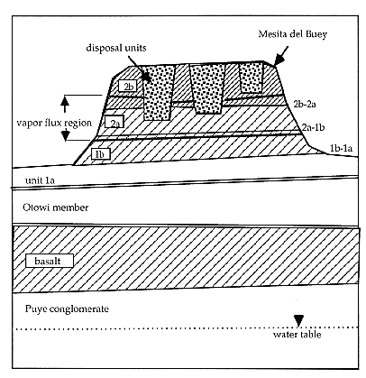
Fig. 1. Sketch of the stratigraphy
cross-section underlying the disposal facilities at Area G. The figure
dimensions are not to scale; the mesa top to canyon floor distance averages
about 100 ft, the canyon floor to the water table is about 800 ft, the mesa
width varies from 400 to 1200 ft. The cross-hatched regions indicate the more
fractured stratigraphic units. The 'vapor flux region' is discussed in the text.
Numerical modeling of transport through the unsaturated zone from the
disposal facility was initiated last year in a 2-D geometry similar to that
shown in Fig.1 (3). This year's effort involves 3-D modeling and requires more
detailed specification of the geometry, hydrologic properties and ground surface
boundary conditions specified to match observed field conditions. Boundary
conditions applied to the numerical computations specify a liquid moisture flux
at the surface which propagates downward to the saturated zone at about 900 ft.
Thus, the unsaturated zone transit time is effectively determined by this
imposed surface recharge rate.
Data needed in the model include the van Genuchten hydrologic parameters
(4),  ,
N,
,
N,  res,
sat
and the unsaturated conductivity, Kunsat(). The
mean values (and variance) for these parameters have been characterized for each
of the units shown in Fig. 1 using site-specific core data down through the
Otowi layer (5,6). Several of the on-going recharge analyses summarized here
utilize these 'stratigraphic-unit averaged values' even though it is known that
the hydrologic parameters are highly variable within each stratigraphic unit. It
is important to determine if model results using the mean values are consistent
with the fielddata, since it is these mean values used in numerical modeling of
the site performance. Initial hydrologic considerations reported last year (1,3)
indicated a best estimate for the recharge rate of 1 mm/yr through undisturbed
locations on the mesa, although the recharge rate varies considerably at
different locations and appears to vary with depth. The variations in recharge
indicate the possibility of significant lateral moisture movement at or below
the base of the mesa, vapor phase interactions within the mesa, or other effects
yet to be determined (7). These issues are explored in the analyses summarized
here.
res,
sat
and the unsaturated conductivity, Kunsat(). The
mean values (and variance) for these parameters have been characterized for each
of the units shown in Fig. 1 using site-specific core data down through the
Otowi layer (5,6). Several of the on-going recharge analyses summarized here
utilize these 'stratigraphic-unit averaged values' even though it is known that
the hydrologic parameters are highly variable within each stratigraphic unit. It
is important to determine if model results using the mean values are consistent
with the fielddata, since it is these mean values used in numerical modeling of
the site performance. Initial hydrologic considerations reported last year (1,3)
indicated a best estimate for the recharge rate of 1 mm/yr through undisturbed
locations on the mesa, although the recharge rate varies considerably at
different locations and appears to vary with depth. The variations in recharge
indicate the possibility of significant lateral moisture movement at or below
the base of the mesa, vapor phase interactions within the mesa, or other effects
yet to be determined (7). These issues are explored in the analyses summarized
here.
ANALYSES
Mesa Top Locations
Detailed surface water balance calculations in the SPUR code (8) predict the
near surface infiltration and percolation beneath the plant rooting depths, by
parameterizing the important physics and relating these parameters to
semi-empirical coefficients. Recharge, or a deep percolation rate, of 4-5 mm/yr
was previously found (9) through a closed disposal unit at Area G. Subsequent
efforts to refine the input parameter values and to examine the sensitivity of
the percolation rate to the input parameters, shows that the model results are
very sensitive to parameters over a range within their uncertainty.
Refining the precipitation estimate at Area G led to a greatly reduced
infiltration (<1mm/yr) through the disposal units predicted by the model.
This result, combined with a small runoff quantity in the surface water balance,
implies evapotranspiration accounts for nearly all of the precipitation.
However, field data for evapotranspiration from surface flux measurements at
Area G (10) and preliminary analyses from eddy correlation meteorological data
indicate the evapotranspiration may be several cm/yr less than the precipitation
rate. This leads to the possibility that some or all of this water in the
surface balance which is unaccounted for ends up as infiltration to the matrix
or to the fracture network.
Profiles of chloride (Cl-) concentrations in samples taken from
three boreholes at mesa top locations within Area G show the greatest
concentration values throughout much of the 'mid-depths' of the mesa volume
(11), as is evident in the profiles in Fig. 2 for borehole 54-1117. The high
chloride concentrations correspond to estimates of the vertical flux which are
negligible in this middle region. Specifically at Area G, the Cl ion data shows
that in the near surface of the mesa to about 40', the recharge rate estimate is
3-6 mm/yr, below 40' to depths of ~70-80', the flux estimate is less than
1mm/yr, and near the base of the mesa (>80' depth) the recharge rate
apparently increases to 5 mm/yr (11). This analysis indicates a moisture sink in
the dry mid-depth region and a moisture source in the region near the base of
the mesa.
Vertical moisture flux estimates have been made from several borehole
moisture profiles using stratigraphic unit averaged hydraulic properties (7).
These estimates are sensitive to local variations in moisture content and
hydrologic properties, and to the averaging used to represent the wide
distributions in hydrologic parameters from the field samples. An example is
shown in Fig. 3(a) which indicates the liquid phase vertical flux in the same
borehole, 54-1117.
This is a particularly dry borehole (located near the mesa edge) which
strongly reveals the characteristics of a dry, vapor dominated flux region.
There is negligible liquid flux throughout most of the profile, except near the
moisture spike at the 1b-1a unit interface horizon identified as the 'vapor
phase notch' (VPN), near 80 ft depth at this location (see Fig. 2(a)). In this
region the flux is consistently upward and decreasing in magnitude above the
moisture spike, while the flux is downward and decreasing in magnitude below the
moisture spike at the unit interface. This curious behavior of moisture
appearing to migrate vertically away from the moisture spike is seen in all the
profiles taken through this interface at Area G (7). This behavior can also be
seen in Fig. 3(a) which shows the vertical liquid flux and an apparent moisture
source term (defined in (7) as the vertical gradient of the vertical component
of flux) near the VPN in borehole 54-1117. The moisture profiles could also be
consistent with vertical variations in hydrologic properties which remain as yet
unresolved.
Profiles showing the magnitude of the liquid flux and the vapor flux derived
using methods from (12) are shown in Fig. 3(b) for borehole 54-1117. It is seen
that the vapor flux clearly dominates liquid flow from ~40 ft to 75 ft. This
region agrees with depths where the chloride data increases (Fig. 2(a)), and
where the chloride flux analyses indicate a small or negligible liquid recharge
rate. In this dry borehole, vapor flux dominates over a majority of the profile.
In similar analyses over several borehole profiles at Area G, it was determined
that the vapor flux.
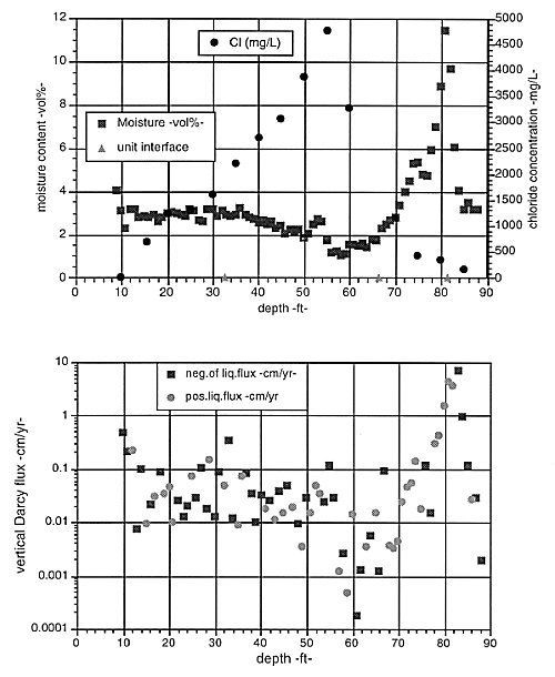
Fig. 2. (Top) Moisture and chloride
profiles in the mesa top monitor hole, 54-1117. (Bottom) Vertical moisture flux
derived from the moisture profile and stratigraphic unit averaged hydrogeologic
properties. 'Neg. of liq. flux' indicates points where liquid flux is downward,
'pos.liq.flux' indicates points where flux is upward.
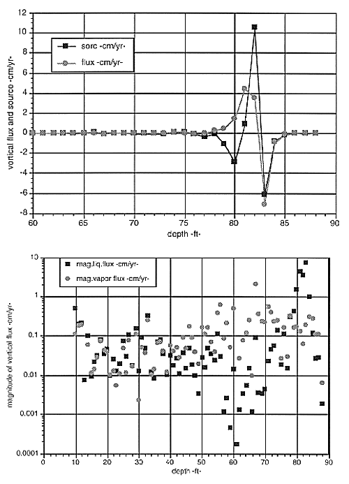
Fig. 3. (Top) Vertical moisture flux
and moisture source in the region of the moisture spike (~80 ft) derived from
the moisture profile and stratigraphic unit averaged hydrogeologic properties.
(Bottom) Magnitudes of the derived liquid flux and the vapor flux in the mesa
top monitor hole, 54-1117 dominated region is very nearly half of the depth
profile through the mesa (12) and agrees closely at most locations with the
region where liquid flux is negligible (7).
This type of flux analysis was completed at several borehole locations at
Area G (7), and shows that a complex flow is indicated under the mesa surface
with the average downward liquid flux of 9 mm/yr (over a wide distribution) near
the surface which decreases in magnitude down to about 30-40 ft depth where the
liquid phase flux becomes negligible. Analyses indicate the vapor flux is
significant, of magnitude ~ 2 mm/yr, only in a region coincident with this zone
where the liquid flux is negligible. Below ~75-80 ft near the base of the mesa
and the elevation of the adjacent canyons, the analyses indicate a possible
source of moisture (as was seen in Fig. 3 ), although the data uncertainty also
allows the possibility that there is a local horizon with unique hydrologic
properties. A deep source of moisture is consistent with the chloride profile
flux results near the base of the mesa.
Recent data provides matric characteristic curves and saturated conductivity
for several borehole samples vertically traversing the vapor phase notch region
beneath Area G. These data can be used to infer vertical flux implied by the
Darcy equation with the matric potential at each field location rather than
'unit-averaged properties' as in the previous analyses. Preliminary review of
these data concur there is a moisture source at the VPN, at the 1a-1b unit
interface.
Additional analyses are made by matching field moisture data with the
calculated moisture profiles for varying percolation inputs into a numerical
model. This has been done both in a simplified unit gradient analysis and in
detailed 2-D unsaturated transport computations (3) as reported last year (1).
These results suggest the same three recharge rate regions under the mesa as
discussed previously, and indicate a deeper fourth region with an increased
moisture flux of about 1 cm/yr within the stratigraphic layers below the canyon
floor elevations. The indicated recharge source near the base of and beneath the
mesa may be lateral movement from canyons or from the west in the gently sloping
stratigraphy. On-going 3-D computational studies are expected to shed some light
on this issue.
Near surface soil moisture data was collected at over 200 sample points
throughout Area G, and a distribution was determined (13). Using the average
soil hydrogeologic properties, and assuming that a unit gradient condition
exists, the distribution in moisture content can be expressed as a distribution
in vertical flux calculated from the Darcy equation. This data indicate a
negligible difference between locations on or off of the disturbed disposal unit
covers and this forms the basis for specifying a single recharge rate on the
mesa top. The data show a broad distribution in recharge over orders of
magnitude, though it is difficult to interpret how the mean of the distribution
is related to the actual recharge rate. The results are consistent with an
estimate for recharge near 5 mm/yr.
Moisture profiles vertically transecting an open disposal unit (7) indicate
a mean moisture content of 8-8.5% by volume, consistent with limited data from
some earlier disposal units (9). The unsaturated hydraulic conductivity
evaluated at this moisture content using properties for unit 2 of the Bandelier
Tuff (used as disposal unit fill) is 5 mm/yr. This value sets the nominal
recharge rate for the mesa top at this disturbed site. In this case, unit
gradient conditions are assumed to apply after the vertical profiles relax to a
mean value of moisture content.
Canyon Locations
Recharge to the adjacent canyons is needed in specifying the complete 3-D
model input for the site performance assessment calculations and could be
important beneath the mesa site if lateral flow is significant, as indicated
under certain conditions in preliminary computational work this year (14). The
results indicate subsurface recharge rates of 5 cm/yr or more under wet canyons
(consistent with some tracer studies indicating relatively rapid transport
beneath some canyon sites) and about 5 mm/yr under dry canyons.
At limited locations, there are matric characteristic curves and saturated
conductivity values at several vertical borehole points, which allow a direct
evaluation of Darcy's equation for the vertical moisture flux using the locally
determined matric potential. This avoids the problem of choosing appropriate
averages for the matric properties and is a more direct evaluation of the flux
than other methods but is subject to large experimental uncertainty and local
variations in the field data set. Results (15) within the mesa and beneath
Canada del Buey (a dry canyon adjacent to Area G) are generally consistent with
the flux results using the stratigraphic unit averaged properties to evaluate
the potential and conductivity from the local moisture profile. The flux in
Canada del Buey is about 5 mm/yr from either method using the geometric mean of
the saturated conductivity and the moisture profile results in the Otowi layer,
which is sufficiently deep that near surface effects are dampened out.
Preliminary evaluation of chloride profile data at the Canada del Buey location
suggests a smaller flux, ~0.5 mm/yr. The discrepancy is not fully resolved but
the larger flux value is used as the 'nominal' boundary condition in the dry
canyon adjacent to Area G for the numerical evaluation of the site in the
Performance Assessment.
Moisture flux results for a 'wet canyon' location from the analysis using
the moisture profile and stratigraphic unit average properties are shown in Fig.
4, using a composite profile from two boreholes (MDC-M5.1 and MDC-M5.9) in close
proximity but with moisture data available over different depths. The derived
fluxes are orders of magnitude larger than seen in the mesa top boreholes, and
settle down to a deep infiltration rate in the Otowi member (the lowest depth
unit in the Figures) of about 30-50 cm/yr. This flux estimate is presumed to be
higher than a typical 'wet canyon' due to a nearby effluent discharge and
because the mean saturated conductivites were used in this analysis. The
geometric mean is assumed to represent a more appropriate average over
non-stratified variations in hydrologic parameter values and is lower by a
factor of two. Some tracer studies summarized in (5) indicate relatively rapid
transport beneath some canyon sites. These results and in comparison to lower
flux estimates from some canyon boreholes (15) indicate a recharge rate of 5
cm/yr is appropriate for the 'wet canyon' adjacent to Area G.
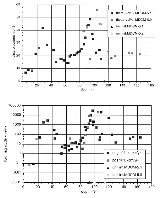
Fig. 4. (Top) Moisture content (theta
-vol%-) verses depth in colocated wells in Mortendad Canyon, MDC M-5.1 and MDC
M-5.9 (data from Ref.(5)). (Bottom) Vertical moisture flux verses depth in
colocated wells in Mortendad Canyon, MDC M-5.1 and MDC M-5.9 derived from the
moisture profiles and stratigraphic unit averaged hydrogeologic properties.
DISCUSSION
There are four separate analyses (1,7,11,12) which confirm a similar picture
of hydrology within the mesa interior characterized by three vertically distinct
regions. The three vertical regions include a near surface region to a depth of
10-60 ft (varying at different locations) where the mean vertical liquid phase
flux ranges from about 0.5 cm/yr (by chloride profiles (11)) to about 1 cm/yr
(7) and this value decreases with depth. The second region occupies the 'middle'
half of the mesa interior, where liquid phase flux is negligible (7), or less
than 1 mm/yr (11), and vapor phase flux dominates (12). The third region lies
near the base of the mesa and is associated with a moisture spike in the
vertical profile at the 'vapor phase notch' or interface between the vitrified
(1a) and de-vitrified (1b) stratigraphic units.
Flux analysis from the moisture profiles in this third region indicate an
apparent source of moisture at the 1a-1b unit interface with significant liquid
phase movement (in the range of several mm/yr to several cm/yr) upward and
downward from that plane. This is accompanied with evaporation (or other sink
mechanism), which decreases the magnitude of the liquid flux going away from the
interface plane (7). The chloride profile data shows the increased chloride
concentrations extend from about this interface plane upward through the region
where the vapor phase flux is seen to dominate, which is consistent with the
assumption of a vapor flux drying this region and driving the local moisture
flux upward towards the vapor dried region. Recent analysis shows the vapor flux
within the mesa is anomalously large (16). The magnitude is consistent with that
expected from a model for diffusion driven by barometric pumping in the presence
of the effective permeability characteristic of the fractured mesa at Area G
(17).
A possible physical mechanism for the apparent source at the VPN is lateral
flow along the unit interface from the adjacent canyons (dominantly north-south
flow) or from canyon sources to the west along the 3% slope from west to east of
the stratigraphic units. Another possible mechanism is deep infiltration through
fractures. This seems plausible at Area G where fractures are frequent above the
vapor phase notch, and the depth from the mesa top is only 100 feet, but it
seems less likely to account for the moisture spike seen at this unit interface
throughout the plateau region, where the plane of the VPN is several hundred
feet below the mesa top at some locations.
CONCLUSIONS
Hydrogeology beneath the mesa surface is complex and remains incompletely
resolved, based on differences in recharge implications from surface water
balance modeling, preliminary evapotranspiration data, and from the several
geophysical profile analyses. The different geophysical analyses concur that
there is a wide variability in recharge and that there appears to be three
regions within the mesa with distinct recharge rates at different depths,
implying a subsurface sink and a source for moisture at two different horizons.
Vapor phase transport and evaporation play an important role in reducing the
tuff moisture content in the middle region within the mesa interior which thus
reduces liquid phase transport through the mesa. Fractures are indicated to play
a key role in this vapor flux and may also be important in transient liquid
infiltration as far as the base of the mesa. The disturbed hydrologic conditions
due to disposal operations may overwhelm the natural benefit of the vapor phase
barrier to liquid transport. Data suggest recharge on the mesa top varies
considerably with location but does not seem to depend on whether the location
is on top of a covered disposal unit or an undisturbed area. A single best
estimate of the average recharge on the mesa top at Area G is currently 5 mm/yr.
The uncertainty in this value leads us to consider a range for the recharge
about this nominal value in the site Performance Assessment.
Recharge to the canyons is estimated at 5 cm/yr beneath a 'wet canyon',
(Pajarito Canyon to the south of the Area G mesa) and 5 mm/yr beneath the dry
canyon (Canada del Buey) to the north of the Area G mesa. This canyon recharge
rate will play a minor role in the site Performance Assessment provided there is
negligible lateral moisture movement from beneath the canyons to locations
beneath the disposal facilities on the mesa top. However, if lateral movement is
significant, the transit time through the vadose zone beneath the mesa may be
controlled by canyon recharge moving laterally beneath the mesa and then
downward, rather than by the low recharge rate through the mesa itself.
Additional field and computational study is needed to resolve these issues if
they are critical to the performance outcome for the site.
ACKNOWLEDGMENTS
This work was supported by the U.S. Department of Energy, Waste Management
Programs, as part of the technical analysis in support of the disposal site
Performance Assessment for Los Alamos, Area G.
REFERENCES
- E. VOLD, K. BIRDSELL, D. ROGERS, E. SPRINGER, D. KRIER, H.J.TURIN, "HYDROGEOLOGIC
ANALYSES IN SUPPORT OF THE Conceptual Model for the LANL Area G LLRW Performance
Assessment", Report LA-UR-96-369, Los Alamos National Laboratory, Los
Alamos, NM, 1996, and in proceedings to Waste Management '96, DOE Conference,
Tucson, Az., Feb. 1996.
- D. HOLLIS, E. VOLD, K. BIRDSELL, J. TURIN, P. LONGMIRE, E. SPRINGER, W.
HANSEN, D. KRIER, R. SHUMAN, "Performance Assessment of LANL TA-54, Area G,
LLRW Disposal Facility - Preliminary Draft", CST-14, RWMDCC #
REPORT-54G-013,R.0, Los Alamos National Laboratory, Los Alamos, NM, August,
1995.
- K. BIRDSELL, W. SOLL, N. ROSENBERG, B. ROBINSON, "Numerical Modeling
of Unsaturated Groundwater Flow and Radionuclide Transport at MDA G", Los
Alamos National Laboratory Report LA-UR-95-2735, Los Alamos, NM, 1995.
- VAN GENUCHTEN, M. TH., "A closed-form equation for predicting the
hydraulic conductivity of unsaturated soils", Soil Science Society of
America Journal, 44, 892-898, 1980.
- ROGERS, D. B., and B. M. GALLAHER, The Unsaturated Hydraulic
Characteristics of the Bandelier Tuff, 132 pp., Los Alamos National Laboratory
Report LA-12968-MS, May 1995.
- D. KRIER, P. LONGMIRE, R. GILKESON, H.J.TURIN, "Geologic,
Geohydrologic, and Geochemical Data Summary of MDA G, TA-54, LANL", Los
Alamos National Laboratory Report LA-UR-95-2696, (also App.2A to ref.2), Los
Alamos, NM, 1995.
- E. L. VOLD, "Analysis of Liquid Phase Transport in the Unsaturated
Zone at a Mesa Top Disposal Facility", Los Alamos National Laboratory
Report LA-UR-96-370, Los Alamos, NM, 1996.
- J.R. WIGHT, and J.W. SKILES, eds., SPUR (Simulation of Production and
Utilization of Rangelands) Documentation and User Guide, U.S. Dept. of
Agriculture, Agricultural Research Service, ARS 63, 372 pp., 1987.
- E. SPRINGER, "Area G Performance Assessment: Surface Water and Erosion",
Los Alamos National Laboratory Report LA-UR-95-2497, (also App.3D to ref.2) Los
Alamos, NM, 1995.
- E. VOLD and B. EKLUND, "Preliminary Summary of Evaporation
Measurements Made at Los Alamos, Area G", Los Alamos National Laboratory
Report LA-UR-96-3499, Los Alamos, NM, 1996.
- B. D. NEWMAN, "Vadose Zone Water Movement at Area G, LANL, TA-54:
Interpretations Based on Chloride and Stable Isotope Profiles", Los Alamos
National Laboratory Report LA-UR-96-4682, Los Alamos, NM, 1996.
- E.L. VOLD, "An Analysis of Vapor Phase Transport in the Unsaturated
Zone with Applications to a Mesa Top Disposal Facility, Part I", Los Alamos
National Laboratory Report LA-UR-96-973, Los Alamos, NM, 1996.
- E. VOLD and B. EKLUND, "Preliminary Summary of Soil Moisture
Measurements Made at Los Alamos, Area G", Los Alamos National Laboratory
Report LA-UR-96-3498, Los Alamos, NM, 1996.
- K. BIRDSELL, W. SOLL, K. BOWER, A. WOLFSBERG, T. ORR, and T. CHERRY, "Simulations
of Groundwater Flow and Radionuclide Transport in the Vadose and Saturated Zones
Beneath Area G", Los Alamos National Laboratory Report LA-UR-97-157, Los
Alamos, NM, 1997.
- D.B. ROGERS, B.M. GALLAHER, E.L. VOLD, "Vadose Zone Infiltration
beneath the Pajarito Plateau at Los Alamos National Laboratory", Report
LA-UR-96-485, Los Alamos, NM, 1996.
- E. VOLD, and B. EKLUND, "Determination of an In-Situ Vapor Diffusion
Coefficient at a Mesa Top Waste Disposal Facility", Los Alamos National
Laboratory Report, LA-UR-96-1848, Los Alamos, NM, draft report May 22, 1996.
- E. VOLD, "A Model for the Effective Diffusion of Gas or the Vapor
Phase in the Unsaturated Zone Driven by Periodic Atmospheric Pressure
Fluctuations", Los Alamos National Laboratory Report, LA-UR-96-4871, Los
Alamos, NM, Dec., 1996.