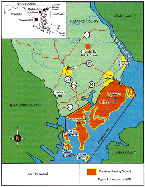
Fig. 1. Location of APG.
Bruce R. Parrish and Donald Urbani
General Physics
Corporation
Ralph Cardenuto, Raphel Corpuz and Matthew G. Wiherle
Aberdeen Proving Ground
ABSTRACT
An assessment of radioactive contamination and unexploded ordnance (UXO) at the Depleted Uranium (DU) testing area of the Transonic Range at the Aberdeen Proving Ground (APG) was conducted in the spring of 1996. DU penetrators were tested at the Transonic Range from 1973 through 1979. Since DU penetrator testing ceased at the site in 1979, the need to release the site for nonradioactive use has become the goal of the U.S. Army Research Laboratory (ARL), and the APG Health Physics Office.
APG is a Test and Evaluation Command installation within the United States Army Materiel Command. The mission of the installation is to develop and test military materials and to train officers and enlisted personnel in the use and maintenance of munitions. The installation was established in 1917 as two separate military reservations, APG and Edgewood Arsenal. Both were consolidated into APG in 1971. APG is located in northeast Maryland, has approximately 73,000 acres of land and water and has approximately 55 tenant organizations, many of whom are engaged in munitions development and testing.
This paper discusses implementation of the work plan, radiation survey, and soil data, and the electromagnetic survey results. It discusses comparison of radiation survey data from site structures to guideline values for depleted uranium. It also discusses correlation of gross beta and gamma count rate data from site walkover radiation surveys to soil samples analyzed for depleted uranium content. This correlation allowed delineation of areas greater than the guideline value. This delineation was necessary in order to scope remediation efforts for soil contaminated with DU. In addition to the radiological data, other site data such as UXO density will be presented.
INTRODUCTION
An extensive radiological and hazardous material characterization of the Depleted Uranium Study Area (DUSA) was conducted in order to meet licensee requirements; determine the extent of depleted uranium (DU) contamination; and to gather sufficient data to determine the best remedial options.
The need to perform a radiological characterization is found in NRC's Branch Technical Position (BTP) "When to Remediate Inadvertent Contamination of the Terrestrial Environment." (1). According to the BTP, licensee sites which are no longerused to conduct licensed activities should be remediated to unrestricted use levels within two years of last licensed activity to preclude migration of the radioactivity. A determination was made in 1995 to cease licensed activities at DUSA.
The DUSA is located at a site within the boundaries of the Transonic Range in the Aberdeen Area of Aberdeen Proving Ground (APG). APG lies along the western shore of the Chesapeake Bay in Harford and Baltimore Counties, Maryland, approximately 15 miles northeast of Baltimore (Fig. 1). APG covers 72,516 acres of land and water. The northern portion of APG is referred to as the Aberdeen Area (AA) and the southern portion of APG is known as the Edgewood Area (EA) (2). The AA became a formal military post, designated as APG, in 1917. The EA (formerly Edgewood Arsenal) was appropriated by Presidential Proclamation in 1918.
Fig. 1. Location of APG.
DUSA is located on the southern portion of the Transonic Range and was known as "Lower X-ray" operated by the U.S. Army Research Laboratory (ARL). The DUSA was used for hard-impact testing of DU penetrators. DU penetrators were gun launched against armor targets to test their effectiveness. DU is depleted of the natural percentage of U-235, and contains U-238, U-235 and U-234 all of which are radioactive. The DU penetrator testing is known to have contaminated target material and the surrounding structures and soil. Contaminated materials and soils have been removed from the area since 1979, however a complete characterization has not been performed.
METHODS
Initial steps for the project included collection of a site history of DUSA, development of a work plan, quality assurance plan and a health and safety plan. Prior to developing a work plan, a historical review of the site was necessary to determine the level of effort and resources needed to devote to the project. Once the level of effort was identified, these plans were efficiently developed.
HISTORICAL DATA
The DUSA is located on the southeast end of the Transonic Range and was used for DU testing from 1973 through 1979. Testing consisted of gun launching DU penetrators from two locations at targets mounted adjacent to the X-ray units to the south (see Fig. 2). Stripper/deflector plates located in between the launch or shooting locations were designed to strip or deflect the sabot away from the penetrator while in flight to the targets. Penetrators were either completely stopped in the targets or penetrated (either partially or completely) the targets and impacted into backstops located a short distancebehind the targets. Most of the tested DU melted into the targets and backstops, however some DU fell onto the soils around the X-ray units and targets or was scattered into the surrounding area.
Except for shot target and other designated contaminated materials, most radioactive wastes were handled through established radwaste disposal channels. Shot target and other designated materials were stored onsite in a wooded area located to the east of impact area. The shot target and other designated materials have been remediated, recycled and or disposed in an approved disposal site.
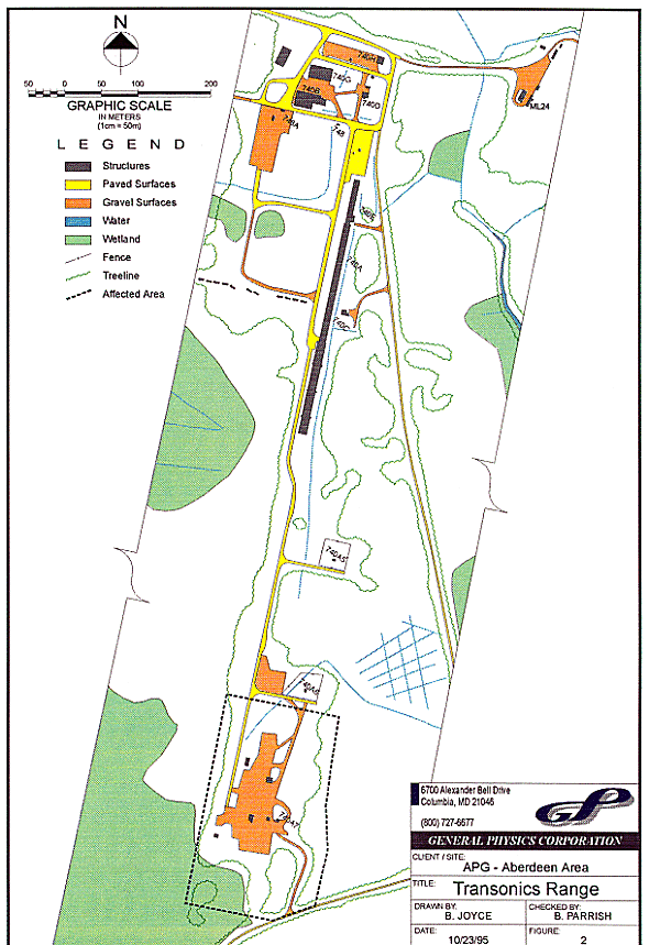
Fig. 2. Transonics range.
Initial site cleanups were undertaken to reduce the radioactive waste inventory and thus allow other non-radiological testing to be conducted at the site. This effort included removing shot target and other materials from the storage area and removal of contaminated soil, sand or other materials. It was estimated that approximately 12 acres should be considered suspect areas.
Soil samples collected by the licensee, post testing, showed levels in excess of the guideline value around the radioactive waste storage area and behind the backstops. Most of the soil contamination was found in storage area. Of the 165 soil samples collected from this area, 37 were greater than the 35 pCi/g guideline value (3). Concentrations ranged from less than 1 pCi/g to a high of 520 pCi/g.
With few exceptions, the areas behind the backstops showed soil concentrations below the limit for free release with few exceptions. Soil samples collected in and around remaining site structures were below the release limit.
Site Description
Figure 2 shows the following site structures: two X-ray facilities (X-ray 1 and 2) with associated target supports; backstops and stripper plates; an electronics support structure; a security container; and the backstop to the Transonic Range. Each of the structures known as X-ray 1 and 2 contain X-ray equipment mounted in U.S. Army equipment trailers. The trailers are surrounded by steel plate, ranging from one half inch to six inches thick. Neither X-ray structure contains penetrations or drains. Test program material was stored in the security container. The original security container was moved to a location west of the Transonic Range Building (740 C) and replaced with a newer container. The replacement Security Container has been classified as an unaffected structure.
The radiological status of X-ray 1 and 2 and associated backstops, stripper plates and supports was unknown but thought not to be contaminated. Scoping surveys were included in the work plan to characterize them. The status of the backstop for the Transonic Range was also unknown. Interviews with range personnel indicated that DU penetrators were not directed at this backstop.
PROJECT WORK PLAN
There were six tasks identified in the work plan as follows:
Task 1 included conducting a geophysical survey to determine site boundary and to divide the site into 200 foot by 200 foot grids for Tasks 2, 3 and 5.
Once the site was free of surface ordnance the Task 2 walkover radiation survey using a 2-inch by 2-inch sodium iodide detector and a 18-inch wide gas flow proportional counter could be accomplished. The walkover radiation survey used CHEMRADs radiation survey technique that transmits detector location and countrate data to a positioning detector interfaced with a computer. This walkover technique enables generation of site maps with contamination contours. As a result of the activities conducted in Task 1, the site survey was expanded outside of 12 acres to cover 14 acres as a result of the activities conducted in Task 1 and areas of higher activity near the site boundary.
Originally Task 3 was to determine the location of submerged UXO and potentially contaminated items using EM-61. However, after considering the hazard of inadvertently detonating proximity fuzed UXO with EM-61, the EM-61 survey was replaced with an all metals magnetometry and ferrous magnetometry survey using CHEMRAD's survey technique.
The Task 4 structure surveys included the electronics building, two X-ray structures and target supports, and the two security boxes. The surveys included measurements for removable radioactive contamination and non-removable gross alpha and beta-gamma radiation. Surveys were conducted in accordance with the methods outlined in Ref. 5. Fixed (non-removable) radiation survey results were compared to Ref. 4 values to delineate are as requiring additional work.
Task 5 was implemented using the preliminary walkover radiation survey results to pinpoint sampling locations. Soils were collected at 50 locations. At each location a sample was taken from the top 4 inches and another taken at 4-8 inches in depth. Soils were analyzed for isotopic uranium. A modification to the work plan was made in order to characterize the site soils for disposal at ENVIROCARE, Utah. This modification consisted of collecting composite samples from the 5 most contaminated grids to analyze for acceptability at the burial site.
RESULTS AND DISCUSSION
Task 1
The 12-acre site and adjoining ranges had been used to test projectiles containing DU, high explosives and other material therefore, the potential for UXO encounters existed. Prior to conducting walkover radiation surveys and collecting soil samples, a UXO survey for surface ordnance was conducted using hand held magnetometry instruments. The U.S. Army Technical Escort detachment was contacted to render hazardous UXO items safe. Because the radiological history of the site was uncertain, a health physicist accompanied the UXO team while the UXO survey was conducted. Radiation surveys showed levels between 0.15 to 0.20 µSv/h (15 to 20 µR/h) south of the backstops to 0.15 µSv/h (15 µR/h) from the backstops to the X-ray buildings and 0.05 to 0.1 µSv/h (5 to 10 µR/h ) from the X-ray buildings north. No removable contamination was discovered during Task 1.
Hazardous UXO were cataloged and recorded on a site map. UXO that were too hazardous to move was designated for field disposal. Those UXO requiring field disposal were surveyed for radiation as well as the general area around the item to ensure that detonation of the UXO would not result in significant dispersal of DU into the surrounding area. A total of 121 UXO items were found during the surface survey. Approximately two thirds of the items were 105 and 155 mm projectiles and almost half of the items contained high explosives. Most of the UXO was found behind the Transonic Range Catchbasin (grid reference A2). The next highest grid containing UXO was grid A3 (13).
Task 2
Chemrad's gross gamma and beta survey results from the walkover survey included dot maps and contours of gross count rate from the gas flow proportional counter and the sodium iodide detector. The beta dot and contour maps show the relative concentration of beta emitting radioactive material lying in the top layer of soil. Beta particles emitted below the surface layer of soil would be absorbed by the soil and would go undetected. The gamma dot and contour maps show the relative concentration of gamma emitting radioactivity lying on the top layer of soil and at a greater depth.
Chemrad incorporated the isotopic uranium results from the 100 soil samples collected and analyzed in Task 5 with their count rate data and generated site contours at beta and gamma count rates equivalent to 35 pCi/g, 70 pCi/g and 105 pCi/g. The data shows, much of the site is affected with beta concentrations in excess of 35 pCi/g. Gamma levels in excess of 35 pCi/g appears to be localized in grids B1, B2, C1, and C2.
Beta concentrations greater than 70 pCi/g were found, in a 50'x50' area in A4; a 75'x75' area in B4 and B3; a large area of 200'x50' in C1 and C2; and numerous 5'x5' areas. Areas showing gamma levels in excess of 70 pCi/g were a 200'x 25' hot spot, and 12 areas 5'x5' to 10'x10'in Grids C1 and C2.
Figure 3 shows the combined beta and gamma count rates equivalent to 105 pCi/g (or three times the guideline value). For gamma contours, the area is reduced to one area 100'x25' in Grids C1 and C2. Areas distinct in each contour level (35, 70 and 105 pCi/g) are the areas on the west side of A4, two areas west of A2, one area south of Building A7, and one area in C1, C2.
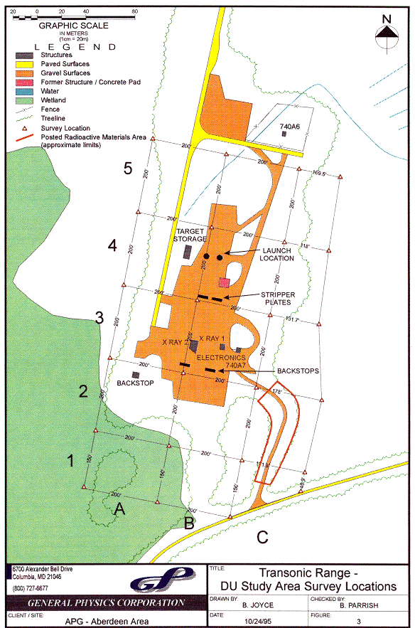
Fig. 3. Transonic range - DU study
area survey locations.
Task 3
Chemrad also conducted a walkover survey using an all metals magnetometer and a ferrous only metal detector of grids A2, C1, and C2. A significant portion of grid A2 is dominated by the Transonic Catch Basin and could not be surveyed. Because of the nature of the catch basin, (i.e., to stop projectiles) much of the grid has a high metal content. Grid C1 and C2 also contain significant amounts of metal. Almost half of C1 and C2 registered metal content despite a rigorous effort to remove surface metal during the initial stage of the project. Thus, metal remains below ground in C1 and C2.
Fig. 4. Transonics range - beta and gamma survey areas over 105 pCi/g.
Task 4
The results of the removable activity surveys for the site structures did not indicate the presence of gross alpha activity or gross beta-gamma activity greater than the guideline values (i.e., greater than 1,000 dpm/100 cm2 (4). Of the 100 removable contamination samples collected, less than 10 percent of the samples reported activity in excess of minimum detection limits.
Fixed contamination results for site structures showed fixed beta-gamma activity above guideline values on the electronics structure, X-ray 1 and 2. Additionally, several of the target stands, stripper bases and backstop bases showed levels in excess of guideline values ( i.e., 15,000 dpm/100 cm2 (4)).
The roof of the electronics structure is contaminated in excess of guideline values between the roof plates.
The trailer in X-ray 1 did not show contamination in excess of the guideline values. The radiological status of the soils under the trailer could not be determined. Significant portions of the steel walls of X-ray 1 exceed the guideline values. Areas of significant contamination included the 6-inch wall facing the target, the 6-inch wall facing the launching locations and the one-half inch thick roof. Significant levels were detected on the base plates of each wall and the support I-beams.
The trailer in X-ray 2 did not show contamination in excess of the guideline values. Much of the soil inside of X-ray 2 was unaccessible and could not be readily sampled. Significant portions of the one-half inch thick roof, 4 inch wall facing the target and interior wall next to the target exceeded the guideline values.
Task 5
Isotopic uranium analysis was conducted on all soil samples. Table I lists the range of total uranium activity detected in each grid.
Table I Summary of Range of Total DU in Soil
In general, isotopic distributions of U-234, U-235, U-238 appear to be those described for Depleted Uranium since the ratio of U-238 activity is > 80% with U-234 at less than 20%. If the activity was natural uranium, U-238 and U-234 would be at 50% since the daughter, U-234, is found present at this level when in natural equilibrium with its parent U-238.
The majority of the contamination appears to be found in the top 1-3 inches of soil. The concentrations from the next 3-6 inches of soil exceeded the top 3 inches in only 8 of 50 sample locations (16%). Only in one instance was the concentration at 1-3 inches less than the guideline value and the concentration at 3-6 inches greater than the guideline value.
The correlation between Chemrad's walk-over radiation survey count rates and DU soil concentrations is good. However, the micro R readings do not correlate well with soil results. In a few instances the soil concentrations were much greater than predicted based on micro R readings.
To screen for non DU contamination, the sample which had a total uranium content of 102,000 pCi/g, was also analyzed for gamma emitting radionuclides and Technetium-99 (Tc-99). No other significant gamma emitting radionuclides were detected in this sample. Tc-99 was also not detected in this soil sample.
Composite soils from grids A2, A3, B1/2, C1 and C2 were analyzed for acceptability at ENVIROCARE's disposal facility. Samples were analyzed for physical and chemical properties including Toxicity Characteristic Leachate Procedure (TCLP) for listed hazardous semi volatiles, and metals, pesticides, herbicides, and explosives. Additionally, samples were analyzed for total volatiles, metals, pesticides and herbicides. No significant concentrations of hazardous materials or explosives were detected. In those instances where hazardous materials were detected, only trace levels (i.e., microgram per liter (µg/L)) were found. These levels were well below the regulatory limits for the hazardous component.
Gamma spectroscopy of the composite soils also did not indicate significant levels of man-made radionuclides or significant amounts of naturally occurring radioactivity. For example, Cs-137 (generally considered man-made) was detected but at concentrations at or less than a pico Curie per gram (pCi/g).
CONCLUSIONS
Based on the radiation surveys no removable contamination was found on the structures surveyed at DUSA. However, fixed radiation levels in A7, X-ray 1 and 2 are in excess of the Ref. 4 guideline values.
Soil data does not show the presence of radionuclides other than isotopes of U-238 and U-235 above ambient levels. The approximate distribution of the uranium isotopes is that of depleted uranium.
All areas showed soil concentrations in excess of guideline values for depleted uranium with the highest concentrations in grids C1, C2, B2, B3, A1 and A4. Much of the contamination is limited to the top 3 inches of soil. Also, it appears that much of the contamination is localized to well defined areas. Any remedial actions will require careful planning and implementation because it is likely that subsurface UXO will be encountered in particular, grids A1, C1 and C2 showed high concentrations of ferrous and non ferrous metal from the magnetometry survey.
The soil does not contain hazardous materials, pesticides, herbicides or explosives above the regulatory limit and would be suitable for disposal at ENVIROCARE's disposal facility in Utah..
REFERENCES