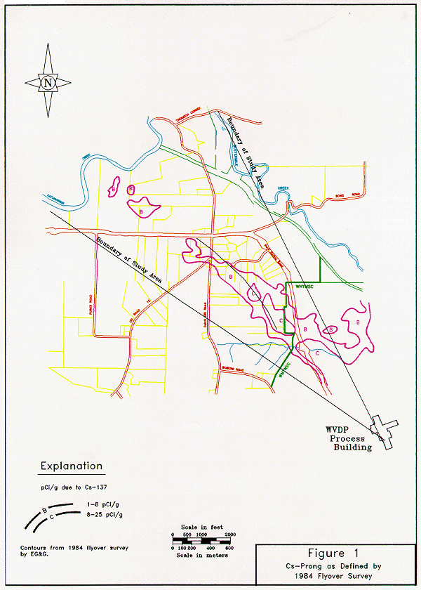
Fig. 1. 1984 aerial survey.
Martin J. Willett
Senior Project Manager
New York
State Energy Research and Development Authority
Larry W. Luckett, CHP
Dames & Moore
ABSTRACT
In 1968, a filter failure at a nuclear fuel reprocessing facility operated by Nuclear Fuel Services at the Western New York Nuclear Services Center (WNYNSC) in West Valley, New York resulted in an airborne release of fission products with deposition of radioactivity on nearby private properties. Ground and aerial surveys performed over the area between 1969 and 1984 identified detectable concentrations of Cesium-137 (Cs-137) at levels below the existing U.S. Nuclear Regulatory Commission (NRC) guidelines necessitating corrective actions.
In 1993, New York State regulatory guidelines and proposed federal cleanup standards for site decommissioning were revised. This prompted The New York State Energy Research and Development Authority (NYSERDA) to evaluate whether the contaminated area would meet the newly revised standards. An investigation of the off-site properties was initiated using an innovative and cost-effective method to quantify radioactivity in soils within the area. This methodology, which met the intent of NRC guidance in NUREG/CR 5849 without the expense of extensive sampling and analysis, was used to evaluate an affected area of more than 404.7 hectares (1,000 acres) encompassing 56 private parcels. Throughout the investigation NYSERDA adopted a proactive public involvement process, keeping property owners and the local community informed of findings.
The WNYNSC Off-Site Radiation Investigation was performed in phases of field sampling, measurement, and analysis. The observations and survey results indicated that the area of deposited Cesium 137 (Cs-137) was adequately bounded and quantified by the survey procedures used. Within a 18.8 hectare (46.5 acre) focus area, test plots were used to calibrate field instrumentation and determine the vertical and spatial distribution of contamination. As a result, eight instrument readings in each 10m x 10m grid provided rapid quantification and location of Cs-137 and an indication of the average and 95th percentile Cs-137 activity which was required to meet regulatory requirements.
An assessment of potential doses to individuals in the off-site area indicates that, under current and postulated future land uses, conservative assumptions on personal exposure result in a projected annual dose to the maximally exposed individual below .08 mSv. The calculated upper bound doses are in the range of doses suggested by proposed federal criteria (.15 mSv per year) and New York State guidance (.10 mSv per year). Regulatory agency review of the study concluded that the characterization was thorough and that no additional action was required.
INTRODUCTION
The Western New York Nuclear Service Center (WNYNSC) is located approximately 50 kilometers (30 miles) south of Buffalo, New York. The WNYNSC occupies 1,354 hectares (3,340 acres) almost entirely within the town of Ashford in Cattaraugus County. Facilities at the WNYNSC include a former, commercial, nuclear fuel reprocessing plant that was operated by Nuclear Fuel Services, Inc. (NFS) from 1966 to 1972. Title to the WNYNSC is held by the New York State Energy Research and Development Authority (NYSERDA) on behalf of the people of the state of New York.
In 1968, NFS reported an airborne release of radioactivity that exceeded the release rate authorized under its operating license. During the release, winds carried radioactive materials to the west and northwest, some of it reaching areas outside the WNYNSC boundary and on to private properties. The private properties affected consisted primarily of open field, cultivated farmlands, and woodlots (1).
A surface soil sample taken northwest of the process building main stack and near the WNYNSC boundary in 1971 showed a radioactivity concentration of 2.14 Bq per gram (58 pCi/g) of Cs-137 (dry). In 1979, an aerial survey of the area surrounding the WNYNSC was performed that identified an area of gamma radiation slightly above detection level of .095 - .11 µSv/hr (9.5 - 11 µR/hr) to the northwest of the process plant and extending beyond the WNYNSC boundary (2). The elevated radiation levels outside the boundary of the WNYNSC were attributed to Cs-137 and contributed .014 -.024 µSv/hr (1.4 - 2.4 µR/hr) to the total gamma exposure in that area. Subsequent aerial surveys (Fig.1) confirmed the presence of the off-site area which, due to its shape and radioactive content, has been referred to as the "Cesium Prong" (3).
In 1982, as part of the West Valley Demonstration Project (WVDP) baseline characterization study, a limited ground survey of the off-site area was performed to verify the results of previous aerial surveys. During that survey, two soil samples taken closeto the center line of the off-site area of the prong were found to contain 1.11 Bq/g and .28 Bq/g (dry) (30 and 7.6 pCi/g). Gamma radiation readings, taken during the ground survey, noted areas as "detectably elevated" which showed gamma radiation levels from .01 - .03 µSv/hr (1 - 3 µR/hr) above the area background level of .10 - .13 µSv/hr (10 -13 µR/hr). An assessment of the data in light of radiation safety standards in effect at that time, found that no further actions were necessary (4). However, changes in regulatory standards since 1982, necessitated the reassessment of data and the resulting conclusions of the 1982 baseline characterization activities.
Fig. 1. 1984 aerial survey.
In 1993, eleven years after the WVDP baseline characterization survey, NYSERDA initiated a ground-level survey. The objective for conducting another ground-level investigation of the radioactive material distribution in the off-site properties was to ascertain more accurately the data extrapolated from the previous aerial and ground surveys. This data would then be used to determine whether under current or projected land uses, personal exposures resulting from residual contamination in the off-site area will meet proposed regulatory guidelines and what, if any, measures might be necessary to limit individual exposure to that radioactivity. The information obtained was documented (5) and used in the Environmental Impact Statement (EIS) being prepared for completion of the WVDP and closure of existing facilities at the WNYNSC.
APPLICABLE REGULATIONS AND REGULATORY GUIDANCE
In 1994, both the Environmental Protection Agency (EPA) and the NRC issued draft regulations for radiological cleanup standards that recommended a dose limit of .15 mSv/yr (15 mrem/yr) in excess of natural background radiation over the first 30 years (6,7). In an internal administrative guide, the New York State Department of Environmental Conservation (NYSDEC) described a dose guidance for sites contaminated with radioactive materials, which states that residual contamination must to be as low as is reasonably achievable, and less than .10 mSv/yr (10 mrem/yr) above that received from background radiation (8). Understanding how the regulators would apply the new standards was necessary for NYSERDA to determine survey data objectives and to present the public with a clear understanding of what criterion would be used by the regulators to evaluate the site status.
Since the basis for establishing soil radioactivity guidelines is to limit individual health risks by controlling the accumulated radiation dose to the individual (9), expressing the release criterion as a dose rate rather than a total dose introduces uncertainty in applying the limit to the off-site properties. The basic assumption in stating the limit as an annual dose rate is that it will be acceptable for the entire duration of the exposure. In the case of a residential exposure scenario, the assumption is that the residents of the site will be exposed for thirty years. In the area adjoining the WNYNSC, the only significant radionuclide is Cs-137 with a half-life of 30.2 years. This means that if an initial dose rate of .15mSv/yr (15 mrem/yr) were present at the site, it will be reduced to only one half as much in 30 years, resulting in an estimated dose to a resident 30 percent below the accumulated dose basis for the guideline. One consequence of this is that property with residual radioactivity of short half-life may be identified as requiring management or cleanup when it actually was already below the level that would produce the equivalent accumulated dose.
INVESTIGATION PLANNING
Although previous information from past surveys of the area did not indicate that there were any safety concerns, NYSERDA needed to develop a community information plan that would keep local residents, public officials, and news media informed without undue alarm. To assist with public relations planning, NYSERDA initiated discussions with several government agencies including, county health department and legislative officials, local town board members, the NRC, EPA, NYSDEC, and the New York State Department of Health. As a result, a community relations plan, which included regulatory involvement, property owner notification, press releases, and periodic public meetings was initiated. NYSERDA's staff visited each residence within the off-site area to explain the purpose of the investigation and gain access to each property. During the investigation, quarterly public meetings were held to keep the local community, public officials, and property owners informed of the progress and results of the investigation. The local news media was notified and kept informed during each phase of the study and a newsletter was sent to a regional audience of interested citizens. A more detailed discussion on the public relations activities can be found in a paper entitled Knock, Knock! Who's There? The Government. A Case Study in Proactive Public Involvement and Risk Communication in the WM'97 proceedings.
Field survey plans were made in consultation with interested regulatory agencies and local environmental groups, to ensure that a comprehensive plan involving each agency's concerns and requirements were incorporated. In addition, due to the large uncertainties associated with historical data and changes in regulatory guidance, contingency plans for remedial actions had to be addressed prior to field activities. Plans would also have to be executed without repeated or prolonged field activities to maintain public support. To accomplish this, a phased approach using field instruments to estimate Cs-137 concentrations in soil rather than extensive soil sampling was used. The investigation began with a scoping survey, designed to quickly measure the radiation levels and spatial distributions of contaminates within the larger area. A subsequent characterization phase was implemented to evaluate the "focus area" identified during the scoping survey. The sampling plan was designed to be flexible, expanding or contracting as the data necessitated while providing enough detail and sensitivity to evaluate potential doses to residents at or below regulatory guidelines.
SCOPING SURVEY, CHARACTERIZATION ON A COARSE GRID
During the period November 1993 through January 1994, field activities for measurements of gamma radiation and collection of surface and near surface soil samples at 44 locations in the 404.7 hectare (1,000 acre) area were performed. Coarse-grid sampling locations were established to allow detailed measurements in the affected areas showing the largest deviation from background as identified in aerial surveys (1979 and 1984 aerial surveys). A 100-meter grid pattern was designed for the area outlined in the 1979 aerial survey falling within 0.5 km of the WNYNSC site boundary. This grid pattern expanded to a 200-meter pattern beyond 0.5 km of the WNYNSC boundary and extended out to 1.8 km. In addition, three background locations were identified to provide radioactivity and radiation levels for areas that were not affected by radioactive emissions from prior reprocessing or WVDP activities.
Radiation data was gathered at each sampling location using three different types of instruments. Radiation levels were measured using a high pressure ionization chamber (HPIC) and a tissue-equivalent dose rate meter (microrem meter). Surface (0 to 10 cm) and near-surface (10 cm to 25 cm) soils were analyzed in the field for Cs-137 using a sodium iodide (NaI) detector coupled to a multi-channel analyzer capable of detecting .021 Bq/g (.56 pCi/g) of Cs-137 in the soil. When field screening indicated Cs-137 concentrations exceeding .074 Bq/g (2 pCi/g), the soil sample was sent to a commercial laboratory for analysis of gross alpha, gross beta, and gamma and alpha spectroscopy. Following field activities, the goal was to correlate field instrument data (HPIC and microrem meter), the soil screening measurements, and the contract laboratory soil analysis data to allow the estimation of Cs-137 levels in the upper soils of the study area, using only field survey instrument readings. The correlation would allow identification of Cs-137 levels without the time and expense required for sample collection and laboratory analysis.
Because HPIC and microrem readings do not have the capability to compensate for variations in ambient radiation sources (comic or terrestrial), they were not sensitive to the very small increases in radiation level due to the slightly elevated concentrations of Cs-137 found in the surface soils. Therefore, instrument readings were not able to be correlated to the Cs-137 present in the soil on the off-site properties. Average HPIC readings in the off-site study area were generally within the range measured at background locations 2.01 nC/kg to 2.32 nC/kg (7.8±0.6 to 9.0±0.6 µR/hr) with the exception of five readings between 2.58 nC/kg and 2.84 nC/kg (10 and 11 µR/hr). The slightly elevated readings occurred in the area identified by previous aerial surveys as having the highest radiation levels in the off-site prong. Microrem levels were slightly higher than average readings taken at background locations but were less than or comparable to the national average level (.06 µSv/hr) and Cs-137 concentrations in soil ranged from less than .037 Bq/g (1.0 pCi/g) to .444 Bq/g (12 pCi/g).
The scoping survey confirmed the location of elevated Cs-137 concentrations shown on aerial survey reports and allowed NYSERDA to focus on an area of approximately 19 hectares (46.5 acres) near the WNYNSC boundary for more extensive evaluation. The scoping survey also showed that field instruments used to extrapolate Cs-137 concentrations in soil have to be capable of responding to only the radiation of the Cs-137 at concentrations as low as .148 Bq/g (4 pCi/g). This was confirmed when a preliminary dose assessment of the area was performed, using the coarse-grid survey data, to plan for the next phase of the investigation.
RADIOLOGICAL CHARACTERIZATION ON A FINE GRID
The Fine-Grid Investigation (FGI) was designed to provide data of sufficient quality to meet proposed regulatory guidelines for determining current and future site status. By using instruments correlated to Cs-137 in the soil, NYSERDA was able to design a survey method that met the regulatory guidance found in the NRC manual NUREG/CR 5849 (10) and reduced the time and expense required to perform the investigation. The major elements of the FGI survey method are described below.
To understand the environmental fate of contaminates within the FGI area, a thorough review of land use activities was undertaken. After reviewing historical maps and aerial photographs it was found that areas currently being used for residences or other human uses (disturbed areas) and woodland areas (undisturbed areas) have remained in about the same conditions since 1968. This information made it possible to evaluate how environmental factors and human uses redistributed the radioactive materials within the FGI area and assisted in planning the FGI survey strategies. This information also made it possible to predict how future land use scenarios would affect the redistribution of contaminates.
The major components of the FGI survey include:
The FGI was performed between July 1994 through September 1995. Before beginning systematic measurements over the area, an evaluation of instrument sensitivity to Cs-137 in the soil and the deposition patterns of the radioactive materials within the study area were performed. Soil samples were taken in 5 cm depth increments to 30 cm from the surface. The samples were collected in five undisturbed and five disturbed 10m x 10m test grids. These grids were located throughout the off-site study area and were representative of each cover and terrain type. Thirty duplicate and 28 laboratory split samples representing 30 percent of the 193 samples collected were sent to an EPA-certified laboratory for quality assurance. The analysis of soil activity by depth indicated that 90 percent of the Cs-137 activity in the 0-15 cm soil layer was confined to the top 10 cm. Approximately 70 percent of the soil activity was in the top 5 cm and appeared to be associated with organic humus soil on the ground surface. In the study region, this organic humus soil is approximately 5-10 cm thick, overlying more impermeable clay.
In order to infer soil concentrations of Cs-137 from field instrument measurements, linear regression analysis was used to correlate field instrument response with the concentration of Cs-137 in the top 5 cm of soil as reported by the laboratory. A replication of the method was performed by the NYSDEC in the FGI area to confirm the method and correlation. A single-channel analyzer, the Eberline ESP-2 with a SPA-3 .79cm x .79cm (2in x2in) NaI detector adjusted to respond to only the pulses corresponding to the energy from Cs-137, was determined to be sensitive enough to infer Cs-137 levels in the soil. The validity of the instrument correlation of counts to soil activity was verified by comparing the activity estimated from survey readings with analytical results for soil samples taken at intervals during the survey. As expected, the correlation was better for higher activity levels. Although less precise at lower levels, the instrument was found to overestimate the actual soil concentration, and thus was conservative for this application.
Fine Grid Survey Results
The FGI survey data set consists of over 35,000 instrument readings in three modes and analysis of over 200 soil samples. The surface area surveyed contained over 1,500, 10m x 10m grids. The average concentrations in each 10 m x 10 m grid ranged from .12±0.05 Bq/g (3.3 ± 1.4 pCi/g) in disturbed areas to 1.28±0.30 Bq/g (34.7 ± 8.2 pCi/g) in the undisturbed woodlands. Cs-137 concentrations at subsequent depths were based on the concentration ratios observed in soil samples sent for laboratory analysis from locations in the initial test grids.
Where the surface area had been disturbed by human impacts, radiation from Cs-137 was only slightly distinguishable from ambient gamma radiation background. Within the undisturbed woodlands, this survey delineated an area with statistically elevated Cs-137, similar to the area identified in the aerial surveys.
Analysis of surface soils showed that the Cs-137 concentration might vary by a factor of two to three within a meter or two of the measurement location. This variation appeared to be due to local surface effects, (e.g., driplines from trees and limited variations in thickness of the humus), rather than isolated particles of higher activity.
Walkover surface measurements identified 29 10m x 10m grids where the peak count rate observed in one quarter of the grid was greater than three times the average count rate in that grid. Detailed resurveys of these grids demonstrated that hot particles were not present.
The gamma radiation dose rate survey results indicated that there were localized regions in the study area in which the dose rate averaged over an area of 50m x 50m (an area determined to be a reasonable size for evaluating residential scenarios), was .012 to .015 µSv/hr (1.2 to 1.5 µRem/hr) greater than the ambient background of .037 µSv/hr (3.7 µRem/hr). This level of external gamma radiation dose rate is within the variation of dose rate reported around the WNYNSC by previous aerial surveys (3).
The local variations in soil radioactivity appeared within the broad Gaussian pattern of deposition from an airborne plume; on a large scale, the Cs-137 concentration decreased with distance from the peak value along the central radial, and it decreased with distance away from the central radial. Local terrain and surface characteristics had minor influence on the gaussian pattern. Figure 2 shows the Cs-137 soil concentrations from this survey compared to the contours of the 1984 aerial survey. The deposition area is located by the two surveys; however, the FGI provides the additional detail.
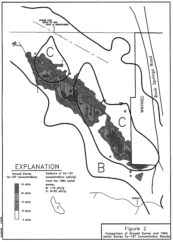
Fig. 2. Comparison of ground survey
and 1984. Aerial survey Cs-137 concentration results.
DOSE ASSESSMENT
A dose assessment for the WNYNSC Off-Site Radiation Investigation was performed to determine a potential radiation dose to an individual in the FGI study area due to the concentration of Cs-137 in the soil. The dose assessment process uses the 95 percent confidence level of the average activity in the soil (inferred from instrument readings of gamma radiation at the ground surface), along with conservative assumptions on individual exposure and land use. An estimate of the potential dose to an individual is calculated using the computer code RESRAD (11). The RESRAD code is an analytical tool for modeling environmental transport of residual radioactivity in the soil. Additionally, the code enables the calculation of potential doses to individuals when appropriate exposure parameters are defined. The code is recognized and used in analysis and comparative studies by both the NRC and the EPA.
Plausible scenarios of current and future land use were identified using actual land use data and standard scenarios described by the NRC and the EPA. The four land use scenarios that were evaluated included:
Values of the critical scenario parameters and corresponding doses are summarized in Table I. Upper bound doses, calculated with the RESRAD environmental transport and dosimetry computer code, indicated that: in current land uses, potential annual doses for the maximally exposed individual are below .05 mSv (5 mrem) in the current year; in future land uses, the most conservative scenario assumption (i.e., the scenario in which a residence house trailer is located in the 50m x 50m area with the highest Cs-137 contour) results in a projected annual dose to the maximally exposed individual below 0.08 mSv in the current year. Due to the radioactive decay of Cs-137 with a half-life of 30.2 years, annual doses in subsequent years will naturally decrease by 2.2 percent each year.
Table Ia Summary of Parameters Used in Scenario Modeling
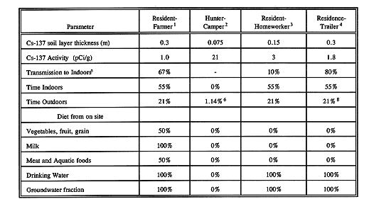
Table Ib Summary of Doses by Pathway for Reference Exposure
Scenarios

CONCLUSION
The WNYNSC Off-Site Radiation Investigation was performed in phases of field sampling, measurement and analysis. The observations and survey results indicate that the area of deposited Cs-137 was adequately bounded and quantified by the survey procedures used. The instrument measurements provided a valid representation of the surface deposition that made more extensive sampling and laboratory analysis unnecessary. Eight readings in each 10m x 10m grid provided an indication of the average and 95th percentile Cs-137 activity to meet the characterization and interpretation requirements identified in the NRC manual NUREG-5849.
The dose assessment indicates that, under current and future land uses, conservative assumptions on personal exposure result in a projected annual dose to the maximally exposed individual below . 08 mSv (8 mrem) in the current year. The calculated upper bound doses are in the range of doses suggested by proposed federal decommissioning criteria .15 mSv/yr (15 mrem per year) and state guidance .10 mSv/yr (10 mrem per year).
REFERENCES