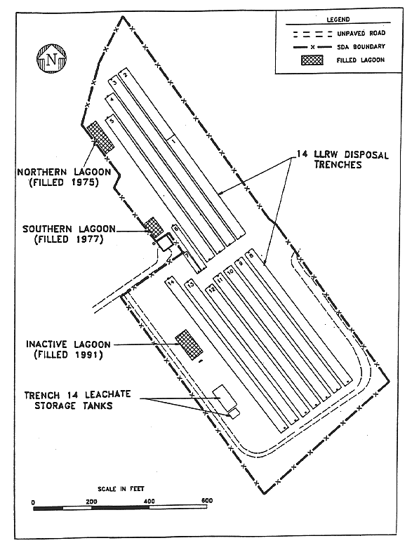
Fig. 1. State licensed disposal area.
T. L. Sonntag, M. R. Weishan, D. D. Miller
New York
State Energy Research and Development Authority
ABSTRACT
The New York State Energy Research and Development Authority (NYSERDA) has completed three projects designed to reduce or eliminate water accumulation in the state-owned, shutdown, commercial, low-level, radioactive waste disposal area (SDA) at West Valley, New York. Results to date have shown that these projects have successfully reduced water infiltration into the disposal trenches, which has minimized the potential for a release of leachate from the disposal area and reduced leachate generation.
Currently, NYSERDA is working to develop a long-term management strategy for stabilizing and closing the SDA. This process is expected to take several years before site closure activities can begin. As implementation of any final closure option will require treatment of the trench water in the SDA, limiting further water accumulation will significantly reduce the final closure costs.
This paper discusses our experiences leading to selection and implementation of three different technologies, particularly their effectiveness at reducing water accumulation.
INTRODUCTION
The state-owned, shutdown, commercial, low-level, radioactive waste disposal area (SDA) occupies approximately 6.07x10⁴ square meters of the 1.35x10⁷ square meter Western New York Nuclear Service Center (Center). The Center is the site of the world's first commercial nuclear fuel reprocessing plant and is located 50 kilometers south of Buffalo, New York, near the hamlet of West Valley. The New York State Energy Research and Development Authority (NYSERDA) holds title to and maintains the Center on behalf of the people of New York State, with the exception of approximately 8.09x10⁵ square meters under exclusive use and possession of the United States Department of Energy for the purpose of carrying out the West Valley Demonstration Project.
State-Licensed Disposal Area Description
From 1963 to 1975, Nuclear Fuel Services (NFS) operated the SDA as a disposal site for low-level radioactive waste. Approximately 6.65x10⁴ cubic meters of packaged waste were disposed of in two sets of parallel trenches referred to as the North and South areas. Each area contained seven trenches and were numbered 1 through 7, and 8 through 14, respectively (Fig. 1). Typically, trenches were 170-meters long, 6-meters deep, and varied in width from 6 meters at the bottom to 11 meters at the top, except for two specially constructed trenches (Trenches 6 and 7). Wastes placed in the trenches were then covered with soil that was excavated during trench construction.
Fig. 1. State licensed disposal area.
The disposal trenches were excavated into the native Lavery till, which, due to its clay content and overconsolidation, is highly impermeable. However, samples taken from boreholes have indicated that the upper three meters of the till is fractured as a result of weathering and is generally more permeable than the deeper unweathered till.
Early Water Infiltration
Due to the humid environment in the region and the very low permeability of the unweathered till, water enters the trenches through the upper weathered till or the trench covers and accumulates there. Water that enters the trenches and contacts the disposed wastes mobilizes the radionuclides and other waste contaminants contained in the wastes and is called leachate. In 1975, leachate levels rose above the original ground surface and seeped laterally through two trench caps into an adjacent brook at the north end of the SDA. NFS immediately ceased disposal operations and waste has not been disposed of since.
Following the seepage incident, NFS pumped and treated leachate from the disposal trenches. To minimize infiltration of water, NFS redesigned and reworked the trench covers. Individual mounded caps replaced the single umbrella-type cover over the northern trenches. The clay cap thickness was increased from 1.2 to 2.4 meters. Several trench caps were stripped and new compacted clay was added. While these improvements successfully reduced water infiltration, they did not completely eliminate it (1).
Site Management by NYSERDA
In 1983, NYSERDA assumed management responsibility for monitoring and maintaining the SDA. Initially, NYSERDA improved maintenance practices to further reduce water infiltration; the grass cover was improved to reduce surface desiccation, routine rolling of the caps was initiated to seal any desiccation cracks near the surface; and regrading of swales between caps was done to improve drainage.
Responding to rising leachate levels in Trench 14 in 1986, NYSERDA removed a relatively large, permeable, stratified sand and gravel body located west of Trench 14 and replaced it with compacted silty-clay till. Historical information suggested that the sand and gravel body extended eastward through Trench 13 and into Trench 12.
Following this work, Trench 14 water levels rose at a much slower, but steady rate until sudden increases in the Trench 14 leachate level occurred as a result of heavy rainfall and snowmelt in late 1990 and early 1991. This was followed by a dramatic rise in the Trench 13 leachate level providing evidence of the suspected hydraulic interconnection through a sand and gravel body between Trenches 13 and 14 (Fig. 2).
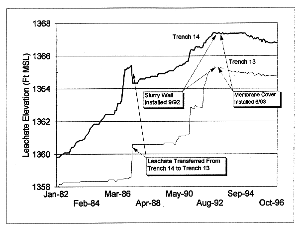
Fig. 2. Trench 13 & 14 leachate
levels.
TRENCH 13/14 INFILTRATION CONTROLS PROJECT
In early 1991, NYSERDA initiated a study to identify the source and pathway of the water entering Trenches 13 and 14 (2). The study evaluated the potential for horizontal migration of groundwater as well as vertical infiltration through the cap of these trenches by installing 28 shallow- and deep-screened piezometers south and west of Trenches 13 and 14. Precipitation, groundwater levels, and trench-water levels were monitored concurrently. The study did not identify a single source for water infiltration or quantify the relative magnitude of each source. Consequently, NYSERDA decided to install both a vertical below-grade barrier and a surface barrier to address leachate accumulation in Trenches 13 and 14.
Design Considerations
The Trench 13/14 Infiltration Controls project was performed as an interim measure under a RCRA section 3008(h) Order on Consent. Since a final closure strategy for the SDA had not been decided upon, NYSERDA chose to avoid complex, multi-barrier technologies that might need to be removed at a future date. Methods evaluated to minimize lateral flow included a slurry wall, soil freezing, and sheet piling. Methods to limit vertical seepage, including soil cover improvement, installation of a geomembrane cover, and bioengineering management were also investigated. NYSERDA chose a slurry wall to divert horizontal groundwater flow in combination with a geomembrane cover to obstruct the vertical seepage of precipitation through the cover. The slurry wall was selected due to its natural properties, relative ease of implementation, relatively low construction cost, and absence of maintenance or operating costs. A geomembrane cover was selected as past, soil-cover improvement work had only limited success and bioengineering management (which had not gone beyond the research in test lysimeters) may not have provided the needed immediate results. A very low-density polyethylene (VLDPE) geomembrane material was selected over other geomembrane materials for its combined flexibility, resistance to cold stress, resistance to tearing or stress cracking, and relative low cost.
The 276-meter long and 9 to 10-meter deep slurry wall was aligned alongside the west (upgradient) edge of Trench 14 and partially wrapped around both the north and south ends. While the primary intent of the slurry wall was to isolate the trench from the adjacent weathered till, the underlying unweathered till was known to contain isolated sand and gravel deposits. Since it could not be determined if these sand and gravel deposits intersected the trenches, it was decided to extend the wall to a level below the lowest trench elevation, thereby reducing the possibility of a deeper groundwater infiltration route.
The VLDPE cover extended from the center line (high point) of Trench 12 across Trenches 13 and 14 and over the slurry wall, terminating in a perimeter drainage collection/anchor trench. Additional Vee-shaped wind anchors were installed in the drainage swales between trench caps to reduce the effects from wind uplift. The perimeter anchor trench was filled with stone and perforated pipe to function as a collection channel conveying precipitation runoff away from the trenches. The perforations limited the amount of runoff entering the drainage pipe which in turn limited peak runoff.
The VLDPE cover was left exposed to limit the impact on future closure options, allow for closer monitoring for possible sinkhole formation, and allow visual observation of the geomembrane for areas of possible leakage. As NYSERDA staff need safe, routine access to areas of the VLDPE cover for collection of environmental data, strips of textured geomembrane were added to the cover providing a slip-resistant pathway.
Construction
The slurry wall was installed during a three-week period in September 1992. The soil excavated from the slurry trench was mixed with bentonite clay and water along the side of the slurry trench, then bulldozed into the trench to form a barrier with a permeability less than that of the unweathered native soil.
Following completion of the slurry wall, work began to prepare the trench caps for installation of the geomembrane cover. This included stripping the grass and topsoil cover from the trench caps, regrading areas to accommodate membrane cover installation, and excavating the primary drainage channel for the membrane cover. Due to heavy rain and snow in November, installation of the geomembrane cover was delayed until the spring of 1993. The geomembrane was installed over a geofabric, which prevented any small stones from penetrating the geomembrane. Work was completed in June 1993.
Performance
Since installation of the slurry wall and geomembrane cover, the water levels in Trenches 13 and 14 stabilized then started a slight decreasing trend (approximately two to four cm/yr) (see Fig. 2). Since recharge to the trenches was cut off, water levels were expected to drop due to downward flow through the unweathered till. In 1995, NYSERDA performed an evaluation of the expected rate of level reduction based on properties (vertical hydraulic conductivity and effective porosity) of the unweathered till, and waste configuration in the trenches (4). The predicted range of annual decreases in leachate levels were consistent with field observations for Trenches 13 and 14.
Routine visual inspections of the VLDPE geomembrane have identified a few minor holes, all smaller than 0.5 cm, which were repaired. In the spring of 1995, test sections were collected from the VLDPE geomembrane to determine if any degradation of the material had occurred in two years of exposure to the elements. In all cases, the materials met or exceeded the manufacturer's specifications for new material.
Special slit-trench monitoring wells, installed to monitor for groundwater mounding outside the slurry wall, have not exhibited a discernable buildup that could overtop the slurry wall and infiltrate into the trenches.
BIOENGINEERING MANAGEMENT PILOT PROJECT
Bioengineering Management was originally identified as a potential alternative trench cover when NYSERDA did its initial investigation into infiltration control technologies in 1991 (3). NYSERDA believed that further investigation of this technology was warranted due to its potential to have a longer useful life with the same effectiveness as traditional barrier covers (e.g. geomembranes, etc).
Bioengineering management is an innovative trench-cover approach consisting of rows of rigid panels to enhance runoff, coupled with vegetation planted between the rows to provide evapotranspiration (ET). Results from test lysimeters at the U.S. Department of Agriculture's Experiment Station in Beltsville, Maryland (5) have shown bioengineering management to be a successful method of controlling deep water percolation in humid environments. Details on the cover project can be found in a paper entitled A Bioengineered Management Technology Demonstration on a Shallow-Land Disposal Trench at West Valley, New York in WM'97 proceedings. An aerial photo taken in the fall of 1993 (Fig. 3), shows the geomembrane cover on Trenches 14, 13 and half of 12 along with the Bioengineering cover under construction on Trench 9.
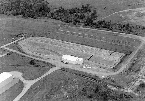
Fig. 3. Trench 13/14 infiltration
controls and trench 9 Bioengineering Management Pilot Project
ADDITIONAL INFILTRATION CONTROLS PROJECT
Due to the success of the Trench 13/14 Infiltration Controls Project coupled with a continuing rise in leachate levels (at a rate of .05 to 0.1 meters per year) in the other trenches, regulatory agencies requested that NYSERDA propose an additional interim measure(s) for the remaining grass-covered trenches (Trenches 1 through 8, 10, 11 and the other half of 12). NYSERDA proposed covering the remaining trenches with a geomembrane cover. A review of hydrogeologic reports, the local topography, and the groundwater monitoring data indicated lateral subsurface water flow into the northern trenches was unlikely due to different topographic conditions in this area (versus the southern trenches). Consequently, a barrier wall was not needed.
Excavation Considerations
The design report prepared for the Additional Infiltration Controls Project (6) included a review of the materials and design features of the initial infiltration controls project, with particular emphasis on reducing the amount of excavation. Although the upper soils are generally free of contamination, NYSERDA had, on occasion, encountered low levels of contamination from past operations when excavating in the SDA. Reducing excavation limits the amount of soil and sod to be checked for contamination, minimizes the potential for having to manage contaminated soil, expedites construction, decreases construction costs, and makes the trench covers less vulnerable to weather during construction. As a result, NYSERDA decided to install the geomembrane directly on top of the existing grass.
An overland radiation survey was conducted in advance of construction to identify areas of surface or near surface contamination. This survey allowed for design changes, to avoid contaminated areas prior to excavation, thereby saving time during construction.
Limiting Peak Runoff
The area to be covered by this project was over three times the area covered during the Trench 13/14 Infiltration Controls Project. A key part of the design was to establish a drainage and erosion plan that would limit peak runoff rates at or below those prior to installation of the cover. Also, erosion control measures needed to be implemented at discharge locations since active erosion existed at nearly all of the locations where water discharged from the SDA.
The runoff collection system for the initial project required substantial excavation. To minimize excavation for the additional cover, earthen berms were designed to form above-grade runoff detention areas adjacent to the trenches. Five detention areas were planned and each detention area would discharge to an existing runoff location. The geomembrane cover would be extended through the detention areas to act as a liner, virtually eliminating the possibility of water in the detention areas infiltrating into the adjacent trenches.
A conservative, 25-year, 24-hour storm was used for the design rainfall. A comparison of design discharges from the grass-covered trenches with those from the geomembrane, with and without the detention areas, showed that peak runoff would increase from 40.8 cubic meters/sec to 90.0 cubic meters/sec without detention areas. Detention areas were designed to reduce peak runoff to 35.8 cubic meters/sec, below the preproject peak runoff rates. Design of the detention areas included a smaller, three- or four-inch pipe in the bottom of the basin to limit discharges from smaller, more frequent storms; and a larger overflow pipe to drain the less frequent, but more severe storms after detention requirements were met.
Geomembrane Material Selection and Construction
Placing the geomembrane directly on the grass would require a geofabric material directly beneath the geomembrane or a geomembrane with a high puncture resistance. VLDPE, the material used for the first cover has a high coefficient of thermal expansion. Movement of the VLDPE placed stresses on some of the monitoring wells projecting through the geomembrane and had, on two occasions broken off the wells. Therefore, a material with a low coefficient of thermal expansion was desirable.
NYSERDA identified two acceptable geomembrane materials: reinforced polypropylene (R-PP) and reinforced ethylene interpolymer alloy (EIA-R). R-PP is a laminate that is highly resistant to UV and punctures and has a low thermal expansion coefficient. It is less slippery than VLDPE as there is some texture created by the reinforcement. EIA-R is a coated fabric with a very high resistance to UV, the highest puncture resistance, and a very low thermal expansion coefficient. EIA-R is similar to R-PP in slipperiness, gaining some texture from the embedded fibers. R-PP and EIA-R cannot be bonded to VLDPE.
EIA-R (8130 XR-5) was the material selected for the additional geomembrane cover. Factory fabrication of the geomembrane in large panels minimized the number of field seams. This was particularly important as the construction schedule indicated that panel installation would occur in the fall when wet, cold weather can hamper field work.
Construction began in August 1995 and was essentially complete with the entire surface of the SDA covered before heavy snowfall in early December postponed construction. Work resumed the following spring to complete final detail work. An aerial photo taken in October 1996 (Fig. 4) shows the additional geomembrane in place.
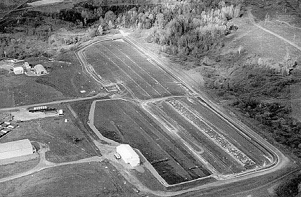
Fig. 4. Additional infiltration
controls in place.
Performance
The water levels in the covered trenches have remained stable since the geomembrane cover was installed in late 1995.
CONCLUSIONS
The water infiltration controls at the SDA have effectively stopped water infiltration into the closed, disposal trenches. The recent cover project minimized risk of an uncontrolled release from the trenches and reduced the quantity of leachate that will eventually need to be treated and dispositioned. NYSERDA will continue to monitor and maintain these enhanced trench covers as planning continues for final stabilization and closure of the SDA.
REFERENCES